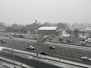
Some solid dandruff in plaza midwood near uptown CLT
-
Hello, please take a minute to check out our awesome content, contributed by the wonderful members of our community. We hope you'll add your own thoughts and opinions by making a free account!
You are using an out of date browser. It may not display this or other websites correctly.
You should upgrade or use an alternative browser.
You should upgrade or use an alternative browser.
Wintry January 21-23 2025
- Thread starter SD
- Start date
Twister
Member
8 miles to my South has a Dusting and here nothing is covered and all we got is a little car topper
Hopefully it’ll start here soon. Humidity jumped from 33 to 39 in the last 15-20 min…I must be missing something mpings all around me
beanskip
Member
Moderate sleet and 37.8F/23 in Tallahassee. Let the games begin.
We (Pickens Co. GA) were just added to the WWA a few moments ago. Very surprised and hopeful. Excited for all of those down south, but also jealous. So far ... nothing here in Jasper.
Dusting in Piedmont. Roads got it first
mydoortotheworld
Member
Snow still coming down here although lightened up a bit in the Brookhaven/N Druid Hills area just a little NE of ATL proper. If you own a RWD car forget about it, you'll get stuck. Drove out for a bit to pick up some meds at the store and slipped out and nearly got stuck multiple times. 85 around here has slowed to a crawl. I don't have a ruler on me but just using my best judgement I'd say half an inch, maybe a hair more has fallen.
CltNative90
Member
Small flakes just started here about 3 miles southwest of Uptown.
SimeonNC
Member
Seeing flurries
connorsclimate
Member
Anyone have an idea of when the dry air will let snow fall around Raleigh???
Sctvman
Member
Freezing rain mixing in with a little bit of sleet has started on James Island
bud006
Member
Just walked for 40 minutes. Think I saw about 40 dandruff flakes, lol. At least we got ours 11 days ago. The light snow earlier was a bonus.
Everyone enjoy the snow!
—30—
Everyone enjoy the snow!
—30—
Psalm 148:8
Member
- Joined
- Dec 25, 2016
- Messages
- 344
- Reaction score
- 789
NW trend did it again!! Now under a Winter storm warning!! Climatology for the win!!
Catfish
Member
Winter Storm Warnings expanded in GA even includes Cobb where all we’ve seen is flurries
packfan98
Moderator
WolfpackHomer91
Member
Snow Flurries In Mooresville ...Linwood rd /hwy 152
Snowdawg
Member
Light snow--Kinston NC
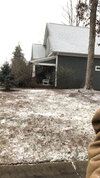
It’s beautiful guys. Atypical dendrites for this area.
vsublazer
Member
packfan98
Moderator
Flurries have started here in Randolph County!
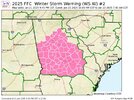
Man. They even were more aggressive than everything elseSnowmageddon 2.0 is happening so they expanded the WSW north for unsafe travel.
View attachment 166480
bud006
Member
And I just saw I’m now under a Winter Storm Warning. OK … maybe we can finally get the column completely saturated and get a little bit?Just walked for 40 minutes. Think I saw about 40 dandruff flakes, lol. At least we got ours 11 days ago. The light snow earlier was a bonus.
Everyone enjoy the snow!
—30—
—30—
NBAcentel
Member
It’s picking up
Amazing . 24 degrees and snowing in Pensacola at the same time
AJ1013
Member
5.5” already just north of Pensacola and it’s nowhere near over. FL snowfall record shattered. Amazing.
I can't believe they don't give us at least an advisory. Everybody saying the roads are white. I am shocked by all this. Wow.
ILM radar is down girl friend says it’s picking up in Monkey Junction
Saw 7” in Molino! Obscene5.5” already just north of Pensacola and it’s nowhere near over. FL snowfall record shattered. Amazing.
Stormsfury
Member
Under a WSW here..
Lotsa virga ATM here in Surf City/Topsail..
currently 31F DP of 18
Wasn't @Stormsfury mentioning something about the Gulf Steam???
Interesting "changes" in KILM "update"..
Models have trended wetter and farther northwest today with an
area of low pressure off of the Carolina coast tonight. Snow
totals have increased significantly since this morning with
portions of coastal NC/SC now expecting close to 6 inches of
snow and sleet. The Winter Storm Warning has been expanded
across the entire forecast area with 1 to 3 inches of snow
expected near the I-95 corridor, 2 to 4 inches between I-95 and
the coast, 3 to 5 inches near the coast, and 2 to 4 along the
immediate coastline where some mixing may occur. Periodic
banding will produce a few areas with isolated higher amounts,
especially near the coast where mixing does not occur. High-end
totals around 6 or 7 inches, primarily in the Cape Fear region
and up to 5 inches just inland.
It is possible that this warm nose is muted by an isothermal
layer which will maintain mostly snow and only a brief period
of snow pellets or sleet. There is some confidence with this
prediction as 850 mb winds turn westerly by 02-04Z with a
secondary low developing along the Gulf Stream this evening. Dry
and cold air advection within this layer should promote further
melting and an isothermal profile with mostly snow. Signs of
this are evident as the NAM and hi-res models produce a 0C 850
mb line as far east as the western edge of the Gulf Stream,
indicating deep cold air pushing offshore late tonight.
Yep. You can see it well on SPC mesoanalysis page. Natural tendencies for that Western Wall to be the battleground and best baroclinicity once you send an arctic airmass offshore
NCWeatherhound
Member
Reports of brief dandruff in Johnston and Harnett. The air is still getting primed around here.What is going on over Garner, NC? Returns all around but there? Clayton/Garner?
32° here in Mount Pleasant (CHS) with freezing rain
JHS
Member
Not a single flake here yet.
jtgus2005
Member
Where?NW trend did it again!! Now under a Winter storm warning!! Climatology for the win!!
Verified light dandruff falling in SW Concord!! Finally


