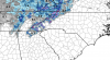
• Hello, please take a minute to check out our awesome content, contributed by the wonderful members of our community. We hope you'll add your own thoughts and opinions by making a free account!

Pattern January 2021 - Joyless January

And all global models with general agreement on something around 5 days out ... maybe thread worthy ??‍♂️ But i dont know when It’s pull triggable
 
It probably won't snow SE of 40/85 but the surface has dramatically improved past 48 hours. It at least makes it interesting.

12/9/18 event was marginal air mass and I thought there was no way it going to snow, so borderline. But, 9 times out of 10 we rain in setups like this.

EPSslptrends.gif
 
It probably won't snow SE of 40/85 but the surface has dramatically improved past 48 hours. It at least makes it interesting.

12/9/18 event was marginal air mass and I thought there was no way it going to snow, so borderline. But, 9 times out of 10 we rain in setups like this.

View attachment 62146
Yeah that was one of the few exceptions and then again we also had a big sfc high in Dec 2018 to transport what little cold air there was to the south, no evidence of anything like that here. For every Dec 2018 you get a Jan 2017 or Feb 2015
 
Finally some real cold air. Love those positive height anomalies near and north of Alaska. That little tweak coupled with continued -NAO and PNA allows us to inject some legit cold into this pattern without having to sacrifice moisture.

View attachment 62147
The surface temp anomalies look trashy, do you think they're underdone?
ecmwf-ensemble-avg-conus-t2m_f_anom-0820000.png
 
850 low is over GSP and tracks down the NC/SC state line...which points to a I-40N more NC/VA border potential. For RDU folks we need this over Augusta/CAE/MYR. Not impossible but we are pushing the limits of how far south this can get.

download.png
 
The surface temp anomalies look trashy, do you think they're underdone?
View attachment 62148
Haven’t been paying any mind to model sfc temp anomalies. That pattern right there on the eps is a cold one literally every teleconnection favors cold here. Remember when it showed a torch for a crappier looking pattern this week that didn’t have high latitude blocking near Alaska?
 
Yep lol just trying to temper expectations atm because experience in these setups says any snow and especially accumulation east of the mtns would be a win. Don’t get enthralled with model snow or p type maps esp this far out
I’ll never be the same after the Feb 2014 Euro model failboat! It still hurts to this day! Warm nose is real!
 
Finally some real cold air. Love those positive height anomalies near and north of Alaska. That little tweak coupled with continued -NAO and PNA allows us to inject some legit cold into this pattern without having to sacrifice moisture.

View attachment 62147
This is arguably the best pattern you could possibly ask for around here for cold and snow.

Only tweak we need to see is just persistence because the longer this hangs around the colder the air masses will get, as more snow gets laid down and more opportunities for big arctic outbreaks are provided
 
I’m still waiting on Brad P. to post some of the ensembles and tell us how in the past those have yet to come to fruition. But in all seriousness, this is great looking pattern. I can’t imagine that he isn’t even getting a little bit excited.


Sent from my iPhone using Tapatalk
 
RAH acknowledges the possibility of a mix, but is not impressed with the chances:

Meanwhile, an upper low will deepen as it moves out of the Rockies
and into the southern Plains. There is fairly good agreement among
the major deterministic guidance with respect to moisture transport
into the area late Thursday into Friday, with rain gradually
overspreading the area early Friday morning. However, there are
differences with how quickly the upper low deepens offshore and
moves out of the area. GFS takes the low out of the area fairly
quickly with strong post-frontal drying from west to east Friday
night. 03.00Z ECMWF and various 03.00Z EC ENS members appear to be
signaling another upper trough moving in from the Great Lakes with a
reinforcing shot of cold air arriving coincident with the departure
of the low. This solution, if it pans out, could result in a brief
mix of rain and snow on the back end
of the precip shield as it
moves out of the area early Saturday morning, but forecast
confidence in this specific solution is quite low at this lead time.
03.12Z deterministic ECMWF has arrived somewhat more in line with
the 03.12Z GFS/GEFS, noticeably absent in this latest run is the
Great Lakes trough and associated cold air. GFS/GEFS and its faster
evolution of the system naturally keeps precip in the form of liquid
vs snow. There isn`t an abundance of cold air upstream to be
imported into the area in the first place, that and the trajectory
of the aforementioned Great Lakes low would result in downslope flow
across the area which is far from favorable for a rain/snow mix.
For
now I am keeping the forecast all liquid until a better model
consensus can be achieved. NBM is closely aligned with GFS timing
and temps and it was a reasonable starting point for this event.
Regardless, temperatures during the latter part of the week into the
weekend will be below normal given cloud cover and precip with highs
in the low/mid 40s, lows within a few degrees of freezing.
Conditions should dry out for the upcoming weekend as the low
departs the area.
Does Brad P work on the side for RAH? Asking for a friend
 
I wonder how long we could Hold on into this pattern, would think the blocking would last for a month or more perhaps
The more anomalous the pattern, the quicker it should breakdown? Kind of like a Cat 5 hurricane, hard to keep it going for a long time , with that intensity? ?
 
Back
Top