Big dog incoming foothills/mtns. Shame it’s still several days out
-
Hello, please take a minute to check out our awesome content, contributed by the wonderful members of our community. We hope you'll add your own thoughts and opinions by making a free account!
You are using an out of date browser. It may not display this or other websites correctly.
You should upgrade or use an alternative browser.
You should upgrade or use an alternative browser.
Pattern January 2020 - Operation Thaw Alaska
- Thread starter KyloG
- Start date
packfan98
Moderator
Takes a slightly inland track and turns off the snow at 276
Webberweather53
Meteorologist
The ECMWF and GFS MJO forecasts continue to correct towards a higher amplitude and longer duration phase 7 event and we’re probably going to end up in phase 8, which is also no slouch when it comes to producing winter storms in NC during Jan. It’s no coincidence imo that the EPS continues to get better just after Jan 20th w/ higher ensemble snow means and probabilities when its MJO forecast is growing more amplified into phase 7 during that time (& history + published literature says it will continue to correct towards a higher amplitude phase 7 event in the coming days).
January MJO phase 7 strikes again.


January MJO phase 7 strikes again.
This is how you get 12”+ snow storms for western NC. Verbatim, not quiet there. 
wow
Member
Works for me 10-12 days out.
Storm5
Member

Lol
Sent from my iPhone using Tapatalk
LovingGulfLows
Member
- Joined
- Jan 5, 2017
- Messages
- 1,499
- Reaction score
- 4,100
Yeah Mountains/Foothills gets hit hard by the phaser...unfortunately for everyone else it cuts inland and warmer air floods in.
Nice Western NC crush-job
Cadi40
Member
So just to reiterate there’s a time period upcoming where we may have a decent shot at more than one wintry event?
Despite being a little far out, one huge positive factor namely for NC, is that wiggle room appears to exist to our south. Meaning we can pull the rug a little from Alanna GA to southern Charlotte NC with mix or rain while heavy snow accumulates for areas like Winston-Salem. Of course, no one wants to hear that and certainly too far out to know how good Frosty is sitting up in Surry County NC.
Chattownsnow
Member
Absolutely. Given the pattern we are entering according to the ensembles I would not be surprised to see things trend colder in the medium and short range. As long as the pattern supports cold in the east we have seen the gfs trend favorably in this way. It just seems like it’s been forever since we have actually been in a pattern where that happens.Gfs always overdoes those type of high pressures in the long range that’s why I believe it was said to avoid looking at those type of details that far out cause they will smooth out .. nothing about the Gfs looks terrible right now
accu35
Member
I'll be happy just to get oneSo just to reiterate there’s a time period upcoming where we may have a decent shot at more than one wintry event?
To say the leastSo just to reiterate there’s a time period upcoming where we may have a decent shot at more than one wintry event?
Chattownsnow
Member
Just a little chaotic lol. Good luck to the models figuring that mess out.
Lol
Sent from my iPhone using Tapatalk
If the GFS was not so dang progressive in the northern stream and the high pressure can hang around longer we are talking big dog. Just small changes are needed, so that’s good. Only negative here is I prefer to see the GFS suppressed at this range.Yeah Mountains/Foothills gets hit hard by the phaser...unfortunately for everyone else it cuts inland and warmer air floods in.
LovingGulfLows
Member
- Joined
- Jan 5, 2017
- Messages
- 1,499
- Reaction score
- 4,100
If the GFS was not so dang progressive in the northern stream and the high pressure can hang around longer we are talking big dog. Just small changes are needed, so that’s good. Only negative here is I prefer to see the GFS suppressed at this range.
Yeah you can see the Euro members Ollie posted the wide range of possiblities of this system....from an early phase to one that doesn't phase until it's off the eastern seaboard. One thing that remains consistent of that someone in the East is getting a massive snow from this.
Basically what we’re seeing is the models doing exactly what the models should be doing. Trying to figure out this pattern but of course it’s too far out so you’re going to get a bunch of different solutions cause they can’t figure out the evolution of these small pieces of energy plus high pressure placement this far out... that’s why at this juncture we need to be locked into the ensembles and nothing more .. once we get into the 4-7 day window operationals will be more telling
wow
Member
In the end it all comes down to the old NC rule - It snows 10 days after a thunderstorm. So far so good.
Now let’s see if follow the rule of losing the storm for 3-5 days.In the end it all comes down to the old NC rule - It snows 10 days after a thunderstorm. So far so good.
accu35
Member
FWIW 12z gefs mean is a little better than 6z. Timing is everything
wow
Member
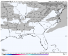
12z Canadian squashes the first wave but looks very nice thereafter with a split flow setup at 240

While the P-type maps haven't loaded, the 12zz CMC looks good at H5

Too suppressed. Not a bad look12z Canadian squashes the first wave but looks very nice thereafter with a split flow setup at 240
wow
Member
While the P-type maps haven't loaded, the 12zz CMC looks good at H5
Gets crushed.. check the meteocentre site for earliest publication of the CMC. But it's the wave right after that looks like a big dog.

Storm5
Member
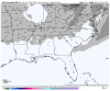
12z cmc

Sent from my iPhone using Tapatalk

Sent from my iPhone using Tapatalk
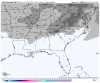
Give me that LP with a 1040 HP in that spot 10 days out, yep I ain't worried.....

Sent from my SM-G950U using Tapatalk

Sent from my SM-G950U using Tapatalk


NCCWOP9077
Member
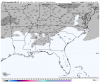
12z GEFS

Sent from my SM-J727U using Tapatalk

Sent from my SM-J727U using Tapatalk
Six Mile Wx
Member

I agree. Way to early to be specific, but that look with that cold air available.... that’s probably freezing or frozen all the way to me with that look.Give me that LP with a 1040 HP in that spot 10 days out, yep I ain't worried.....
Sent from my SM-G950U using Tapatalk
Squashed is good this far out. Idc how good the pattern is we know 9 times out of 10 the s/e will be on the fringe (namely GA-NC cad zones).
Six Mile Wx
Member


Pretty close. Of course, a number of those storms turned out pretty well for RDU too
Everyone should be paying attention to the H5 pattern at this range. Not an individual storm or even an ensemble snow output. How's the GEFS look at H5?
accu35
Member
I've noticed on this time frame of the cmc is what the gefs is picking up on back in Texas with 3 members showing up. This is before the main gulf low.

Patiently waiting for the 12z suite of the European model ???
The JMA looks interesting at the end of it's run


Euro has a much stronger high pressure coming in than the Gfs
wow
Member
A most excellent split flow pattern showing up on the Euro. Confluence to be developing over the NE after low wraps up, juiced up STJ wave over SW at 204 hrs