Nomanslandva
Member
06Z GFS looked more like a coastal but still had a little low in eastern KY screwing things up. I was not real impressed with the EPS for the weekend system this run either.


I doubt it’s virga as dark as those hues over WNC are.So it looks like the UKMET is much colder. I'm not sure how it does with temps, I've always used it just for storm tracks and ideas. Interesting. Is that radar simulation possibly virga, though?
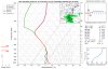
This is an interesting one especially for Tn and WNC peeps. Euro always a degree or 2 too warm and honestly we've seen these pieces of energy hold together a little longer than forecast, wouldn't take much for nice little event. 12z should give some better idea, maybeHere's my full post from over there, some ensemble members and the NAM see it too, to an extent:
Midweek UKMET:
Euro not too far off:
but a little too warm
It's in NAM range now too:
Some EPS ensemble support for north of 40 and elevations on teh plateau and NE TN/ SW VA:
6z GEFS:
A Met over in the SE (Americanwx) was saying earlier in the week not to sleep on this one, since the only thing keeping from being at least a little snow storm (2-4 type deal, my guess not the Met's) was that the vort was not holding together on models at range.
Local news weather is not mentioning it at all and that is an important, but often overlooked component for us, (well at last for my superstitions, lol) Gotta have it something like this be a little sneaky, to maintain tradition.
It wouldn't completely shock me if someone out our way managed a snowflake out of this one.This is an interesting one especially for Tn and WNC peeps. Euro always a degree or 2 too warm and honestly we've seen these pieces of energy hold together a little longer than forecast, wouldn't take much for nice little event. 12z should give some better idea, maybe
12z ICON has more precip this run just a little too warm, the increase in precip is nice to see though.... Still nothing big but step in right directionIt wouldn't completely shock me if someone out our way managed a snowflake out of this one.

Yeah the 0z euro soundings weren't terrible. If we wetbulbed we would only have 950 to the surface above freezing that might be just enough. Weird having BL issues instead of a warm nose6z EPS has a few more members with snowfall down in the Carolina's.
Past 3 runs ending Sat AM.
View attachment 32104
Yeah the 0z euro soundings weren't terrible. If we wetbulbed we would only have 950 to the surface above freezing that might be just enough. Weird having BL issues instead of a warm nose


I like how it now puts some of that northern branch energy in the southern energy to consolidate it. You would think if we can just get it strong enough to precipitate heavy enough to cool the BL we could see some flakes
Sounding isn't bad and very similar to the euro with below 950 being the bugaboo if we fully wetbulbed. With the weak ne flow if we got into steady precip we might get lucky
Yea looks more like cold rain given low rates and spotty moisture. The jumping is not resulting in snow it’s lack of cold air and heavy wall to wall moisture.Gfs is making these types of jumps inside 100 hours, soundings from CLT north was so close if you wet bulb, just 925s are so borderline
Here's my full post from over there, some ensemble members and the NAM see it too, to an extent:
Midweek UKMET:
Euro not too far off:
but a little too warm
It's in NAM range now too:
Some EPS ensemble support for north of 40 and elevations on teh plateau and NE TN/ SW VA:
6z GEFS:
A Met over in the SE (Americanwx) was saying earlier in the week not to sleep on this one, since the only thing keeping from being at least a little snow storm (2-4 type deal, my guess not the Met's) was that the vort was not holding together on models at range.
Local news weather is not mentioning it at all and that is an important, but often overlooked component for us, (well at last for my superstitions, lol) Gotta have it something like this be a little sneaky, to maintain tradition.

I'm assuming here, just based off these images, you might want a stronger wave.
Yea looks more like cold rain given low rates and spotty moisture. The jumping is not resulting in snow it’s lack of cold air and heavy wall to wall moisture.
Not really too warm 5 to 10 degrees. No ski resort wants to see another heavy rain event and temps above freezing day and night. Their gains keep getting washed away. Wrap around as shown could easily be 6”+ given what I’m seeing.GFS sure was close to a absolute bomb for mountains of WNC and NE Tennessee. Still a solid wrap around for those areas with probably 4-6 inches. This needs to keep up so I can take my first trip to Maggie Valley.


I'm changing the "Dislike" button to a neutral action, because I'm not sure it's understood that a dislike removes reputation points from people's score.
Edit: Changed, dislike away.
I don’t believe this is mountains only ... look at the strong feed into NC and temps are plenty cold enough to get good snow showers .. snow showers for a lot of NC if that verifies .. probably no accumulations but we will take itWrap around looks good 0z Sunday on GFS. Warning criteria snows. Heavy rates. Mtns only.


This doesn’t work for Tapatalk right?
Sent from my iPhone using Tapatalk
CMC is better for all of western NC and outside mtns north of i40. Temps borderline. Thurs.

.gif")