ICON hammers WNC next weekend..great track

Precip never gets back to the mountains.Through 168 the 850’s are a little warm it seems. Mountains look to score.
Icon struggles mightily with surface temps. Usually way too warm.I would wager against the ICON. Temps too warm I doubt we go from 40s rain to 33 snow. Poss but any unfavorable track trend would even be cold rain in Boone NC.
Still looks like a cold rain to me. Other guidance is fairly warm too. Setup doesn’t look favorable for snow.Icon struggles mightily with surface temps. Usually way too warm.
ICON is definitely warm biased with surface temperatures ... we just need things to cool down a BIT and a big snowstorm for many .. I think we definitely have some good wiggle room for this to happenI would wager against the ICON. Temps too warm I doubt we go from 40s rain to 33 snow. Poss but any unfavorable track trend would even be cold rain in Boone NC.
GFS basically whiffed on high elevations in WNC that actually supported snow that runThrough 168 the 850’s are a little warm it seems. Mountains look to score.
Need the GFS to trend 10 degrees cooler within 150hrs. Icon or not, the setup is there for a cold rain event too for the majority East of the mtns.ICON is definitely warm biased with surface temperatures ... we just need things to cool down a BIT and a big snowstorm for many .. I think we definitely have some good wiggle room for this to happen
GFS basically whiffed on high elevations in WNC that actually supported snow that run

Yeah. With a track like that, climo would win for many areas. Especially those with elevation. We just don’t want that Low to tug inland with already marginal 850’s. Verbatim, I would take my chances with this oneyep, the GFS would have supported snow there if it were to come out like what I saw from the ICON with heavy precip getting over there. 850s are there and it wouldn't take a lot.

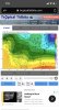
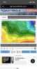
Could the upstate get in on the action as wellThe potential is there for a HECS event but need to see some favorable trends SOON. Below is the CMC, it would not take much of a location error to thump NC with wind and 6-12”+. View attachment 32023
The CMC focuses on a different, earlier storm, same one it had winter weather in NC at 0Z last night. It pushes the GFS storm east and OTSThe potential is there for a HECS event but need to see some favorable trends SOON. Below is the CMC, it would not take much of a location error to thump NC with wind and 6-12”+. View attachment 32023
Yes. Signal is there for a strong storm to rule anyone out. This isn’t the typical light event pattern...the STJ has been and continues to show signs of producing strong storms for the s/e.Could the upstate get in on the action as well
The reality is a few tweaks can get us a solid mountain or upper south event. Us I-20 folks need an alignment of the stars and a consistent signal. As it stands right now we’ve got little to hang out hats on through the first quarter of February. Beyond that is anyone’s guess.
Sent from my iPhone using Tapatalk
I think outside of the mountains the rest of us, as far as January is concerned, might as well go ahead, and snap the ball, take a knee, and head to the locker room, and hope February has Mahomes as QB.I20 will have to wait and hope like all hell we can score in Feb . Thank god the TN and NC mountains are far away . Traveling might be our best bet this year
Sent from my iPhone using Tapatalk
I still think there's potential for wraparound snow for I-20 areas and south.
Going take a young Tom Brady comeback Be more like it. Said young tomI think outside of the mountains the rest of us, as far as January is concerned, might as well go ahead, and snap the ball, take a knee, and head to the locker room, and hope February has Mahomes as QB.
Will go with a simple Kyle Trask ... and win ...Going take a young Tom Brady comeback Be more like it. Said young tom
Brady now lol
Icon struggles mightily with surface temps. Usually way too warm.

We had to wait forever on 2015 watching TN get rocked for two weeks but it paid off IMBY and I think that was the last few days of February.I love the faith but it’s hard to see anything promising for the I-20 folks. We need to see some block and cold air in place. The MJO looks bad LR and the PV isn’t helping.
Sent from my iPhone using Tapatalk