ForsythSnow
Moderator
Here is the WPC's 7th day for snow/sleet. If the models trend colder, that area will likely shift southeast, which would make us all happy.

No. The more consolidated and stronger this system is the more likely it is to be northwest. If you want snow to see the snow line farther south you want the system to trend a little slower and a little weaker.NorthGAWinterWx link said:I think there would be more overrunning west of the apps rather than along the apps or east of the apps. That's why we see higher totals west of the apps on the models. Because west of the apps will be in that colder sector while east of the apps, the SER would still be hanging on.
Sent from my SM-J700T1 using Tapatalk
Would a more consolidated system give more opportunity for I-20 and I-85 folks to get some accumulation?ATLWxFan link said:[quote author=NorthGAWinterWx link=topic=60.msg4771#msg4771 date=1483104508]
I think there would be more overrunning west of the apps rather than along the apps or east of the apps. That's why we see higher totals west of the apps on the models.
Sent from my SM-J700T1 using Tapatalk

Would a more consolidated system give more opportunity for I-20 and I-85 folks to get some accumulation?NorthGAWinterWx link said:[quote author=ATLWxFan link=topic=60.msg4772#msg4772 date=1483104738]
[quote author=NorthGAWinterWx link=topic=60.msg4771#msg4771 date=1483104508]
I think there would be more overrunning west of the apps rather than along the apps or east of the apps. That's why we see higher totals west of the apps on the models.
Sent from my SM-J700T1 using Tapatalk
Would a more consolidated system give more opportunity for I-20 and I-85 folks to get some accumulation?Storm5 link said:[quote author=NorthGAWinterWx link=topic=60.msg4777#msg4777 date=1483105604]
[quote author=ATLWxFan link=topic=60.msg4772#msg4772 date=1483104738]
[quote author=NorthGAWinterWx link=topic=60.msg4771#msg4771 date=1483104508]
I think there would be more overrunning west of the apps rather than along the apps or east of the apps. That's why we see higher totals west of the apps on the models.
Sent from my SM-J700T1 using Tapatalk
Would a more consolidated system give more opportunity for I-20 and I-85 folks to get some accumulation?Tarheel1 link said:[quote author=Storm5 link=topic=60.msg4779#msg4779 date=1483106255]
[quote author=NorthGAWinterWx link=topic=60.msg4777#msg4777 date=1483105604]
[quote author=ATLWxFan link=topic=60.msg4772#msg4772 date=1483104738]
[quote author=NorthGAWinterWx link=topic=60.msg4771#msg4771 date=1483104508]
I think there would be more overrunning west of the apps rather than along the apps or east of the apps. That's why we see higher totals west of the apps on the models.
Sent from my SM-J700T1 using Tapatalk
Would a more consolidated system give more opportunity for I-20 and I-85 folks to get some accumulation?Storm5 link said:[quote author=NorthGAWinterWx link=topic=60.msg4777#msg4777 date=1483105604]
[quote author=ATLWxFan link=topic=60.msg4772#msg4772 date=1483104738]
[quote author=NorthGAWinterWx link=topic=60.msg4771#msg4771 date=1483104508]
I think there would be more overrunning west of the apps rather than along the apps or east of the apps. That's why we see higher totals west of the apps on the models.
Sent from my SM-J700T1 using Tapatalk

welcome!Spurs up link said:Hello i love this site finally registered! Look forward to being part of the group!
Would a more consolidated system give more opportunity for I-20 and I-85 folks to get some accumulation?NorthGAWinterWx link said:[quote author=Storm5 link=topic=60.msg4779#msg4779 date=1483106255]
[quote author=NorthGAWinterWx link=topic=60.msg4777#msg4777 date=1483105604]
[quote author=ATLWxFan link=topic=60.msg4772#msg4772 date=1483104738]
[quote author=NorthGAWinterWx link=topic=60.msg4771#msg4771 date=1483104508]
I think there would be more overrunning west of the apps rather than along the apps or east of the apps. That's why we see higher totals west of the apps on the models.
Sent from my SM-J700T1 using Tapatalk
The models aren't hinting at a strong low because the height gradient in the east tightens which shears the western shortwave thus you get this low amplitude look. There are 2 ways in this look to get a stronger low First is a phased scenario where it's 100% depending on timing of the phase as to who gets rain or snow. The second option is what we saw with the 12z runs yesterday where the heights are more relaxed and there is the ability to have a stronger low pressure and room for amplification. The problem with this is it gives the SER the ability to push back and biases everything north.
You don't need a strong low here to generate a good amount of precipitation. The moist southwest flow aloft over top the air mass already in play will do well at generating precip. The addition of any energy from the west will act to enhance moisture plumes at times. The good thing about this look is horizontal temperature advection is kept at a minimum so we aren't likely to have a blazing warm nose aloft
Sent from my SM-G928V using Tapatalk
Would a more consolidated system give more opportunity for I-20 and I-85 folks to get some accumulation?Storm5 link said:[quote author=NorthGAWinterWx link=topic=60.msg4777#msg4777 date=1483105604]
[quote author=ATLWxFan link=topic=60.msg4772#msg4772 date=1483104738]
[quote author=NorthGAWinterWx link=topic=60.msg4771#msg4771 date=1483104508]
I think there would be more overrunning west of the apps rather than along the apps or east of the apps. That's why we see higher totals west of the apps on the models.
Sent from my SM-J700T1 using Tapatalk

CMC doesn't have a a 6Z, just 0Z and 12Z, like the Eurosigwx link said:[quote author=Stormlover link=topic=60.msg4787#msg4787 date=1483107289]
Spann put this out
That map almost looks like the 6z CMC hour 192

Just pulled this from the GFS. As you can see there is a weak warm layer which is to be expected given the WSW flow aloft but its not a honking +5c nose, its pretty close to a snow sounding. There are a few systems that were similar to this one from the pastmetwannabe link said:The models aren't hinting at a strong low because the height gradient in the east tightens which shears the western shortwave thus you get this low amplitude look. There are 2 ways in this look to get a stronger low First is a phased scenario where it's 100% depending on timing of the phase as to who gets rain or snow. The second option is what we saw with the 12z runs yesterday where the heights are more relaxed and there is the ability to have a stronger low pressure and room for amplification. The problem with this is it gives the SER the ability to push back and biases everything north.
You don't need a strong low here to generate a good amount of precipitation. The moist southwest flow aloft over top the air mass already in play will do well at generating precip. The addition of any energy from the west will act to enhance moisture plumes at times. The good thing about this look is horizontal temperature advection is kept at a minimum so we aren't likely to have a blazing warm nose aloft
Sent from my SM-G928V using Tapatalk
Oh be still my beating heart, the slightest possibility of a winter event without a blazing warm nose..... can it be? Do those still exist? Lol Great explanation by the way

saying a consolidated low would give everyone snow is not a correct statement .NorthGAWinterWx link said:Depending on where you are and the setup, the overrunning is horrible for my area (as of right now). That's why I'd rather have a Gulf low or a low that tracks just across the Gulf coast. The 06z GFS has a high just north of the OH river which would set up snow north, NW and western side of the consolidated low. A consolidated low would be better cause everyone would get snow. The SW flow would have more ice and IP rather than snow. The thickness values aren't even cold enough for snow during the SW flow. The best snow growth is -5c at 850mb.
Sent from my SM-J700T1 using Tapatalk
Just pulled this from the GFS. As you can see there is a weak warm layer which is to be expected given the WSW flow aloft but its not a honking +5c nose, its pretty close to a snow sounding. There are a few systems that were similar to this one from the pastSD link said:[quote author=metwannabe link=topic=60.msg4793#msg4793 date=1483108784]
The models aren't hinting at a strong low because the height gradient in the east tightens which shears the western shortwave thus you get this low amplitude look. There are 2 ways in this look to get a stronger low First is a phased scenario where it's 100% depending on timing of the phase as to who gets rain or snow. The second option is what we saw with the 12z runs yesterday where the heights are more relaxed and there is the ability to have a stronger low pressure and room for amplification. The problem with this is it gives the SER the ability to push back and biases everything north.
You don't need a strong low here to generate a good amount of precipitation. The moist southwest flow aloft over top the air mass already in play will do well at generating precip. The addition of any energy from the west will act to enhance moisture plumes at times. The good thing about this look is horizontal temperature advection is kept at a minimum so we aren't likely to have a blazing warm nose aloft
Sent from my SM-G928V using Tapatalk
Oh be still my beating heart, the slightest possibility of a winter event without a blazing warm nose..... can it be? Do those still exist? Lol Great explanation by the way
NorthGAWinterWx link said:Depending on where you are and the setup, the overrunning is horrible for my area (as of right now). That's why I'd rather have a Gulf low or a low that tracks just across the Gulf coast. The 06z GFS has a high just north of the OH river which would set up snow north, NW and western side of the consolidated low. A consolidated low would be better cause everyone would get snow. The SW flow would have more ice and IP rather than snow. The thickness values aren't even cold enough for snow during the SW flow. The best snow growth is -5c at 850mb.
Sent from my SM-J700T1 using Tapatalk
GaWx link said:[quote author=NorthGAWinterWx link=topic=60.msg4803#msg4803 date=1483110641]
Depending on where you are and the setup, the overrunning is horrible for my area (as of right now). That's why I'd rather have a Gulf low or a low that tracks just across the Gulf coast. The 06z GFS has a high just north of the OH river which would set up snow north, NW and western side of the consolidated low. A consolidated low would be better cause everyone would get snow. The SW flow would have more ice and IP rather than snow. The thickness values aren't even cold enough for snow during the SW flow. The best snow growth is -5c at 850mb.
Sent from my SM-J700T1 using Tapatalk
saying a consolidated low would give everyone snow is not a correct statement .Storm5 link said:[quote author=NorthGAWinterWx link=topic=60.msg4803#msg4803 date=1483110641]
Depending on where you are and the setup, the overrunning is horrible for my area (as of right now). That's why I'd rather have a Gulf low or a low that tracks just across the Gulf coast. The 06z GFS has a high just north of the OH river which would set up snow north, NW and western side of the consolidated low. A consolidated low would be better cause everyone would get snow. The SW flow would have more ice and IP rather than snow. The thickness values aren't even cold enough for snow during the SW flow. The best snow growth is -5c at 850mb.
Sent from my SM-J700T1 using Tapatalk
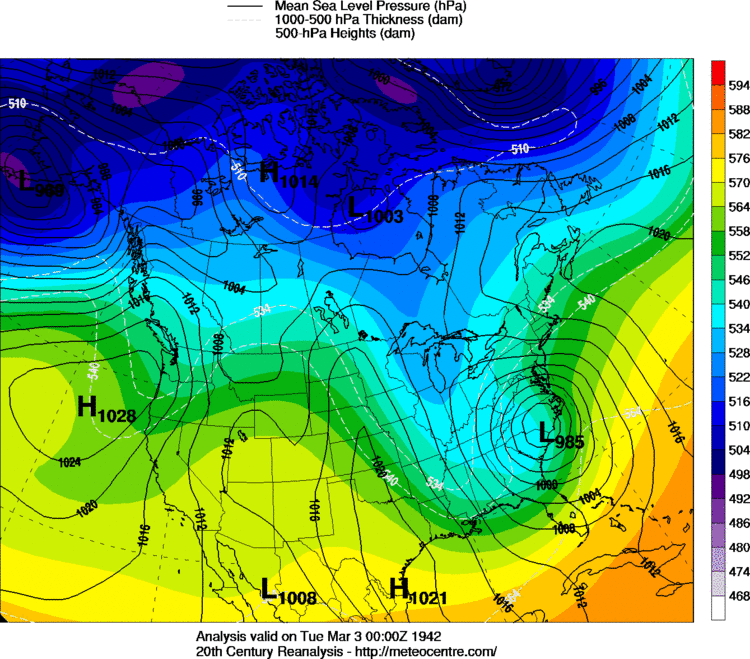
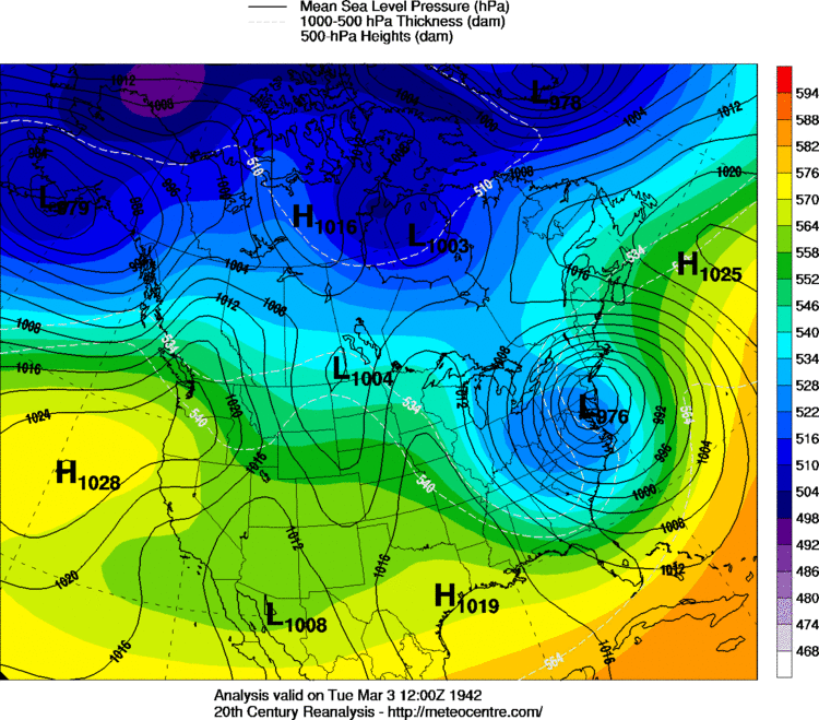
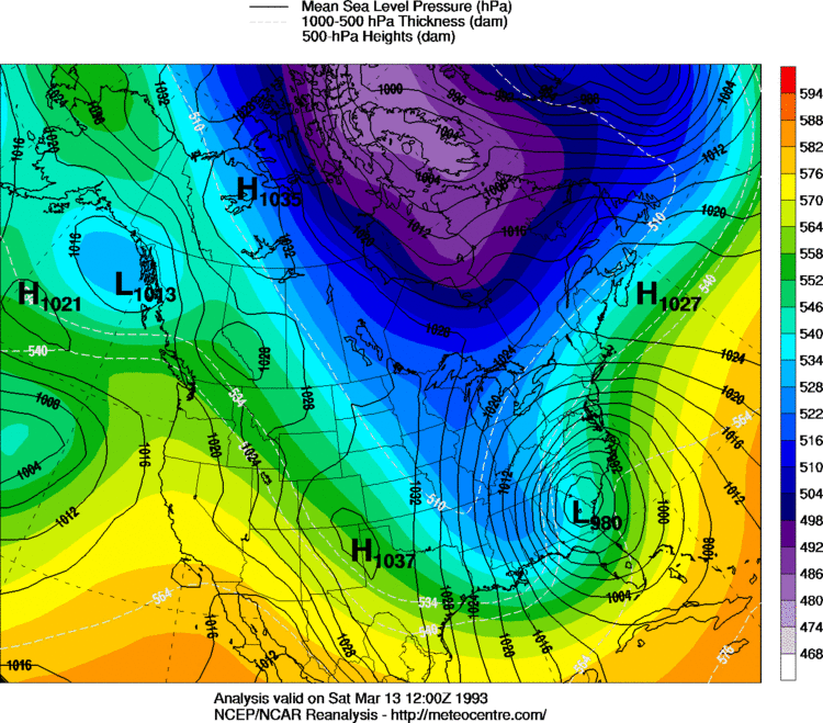
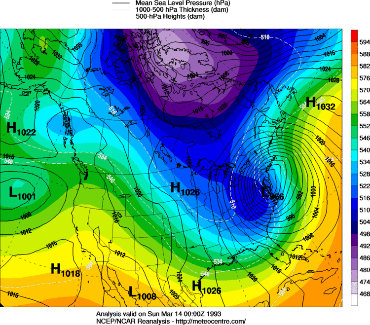
GaWx link said:As far as gulf lows are concerned, I found only three sub 1000 mb lows since the late 1800's that gave Atlanta 3.5+" of SN/IP. One was the ~977 mb 3/1993 blizzard, which was a very rare storm that gave major snow after a changeover from rain that occurred before it passed. The other two lows were in the high 990's.
For the remaining 30 something major SN/IP, the lowest pressure while in the gulf was 1000+. The average is not too far from 1010 mb and a few were as high as near 1020 mb. So, the best chance is from a weak low/overrunning. Some of the biggest SN/IP in Atlanta were from very weak lows (1015+).
The track is almost always through either SE GA or north FL though a few went through central FL. Actually, that is also a common track for many of the big well inland AL/NC/SC big snows as well.


Is it a good time to start a seperate thread on this?SD link said:I'm curious about the pattern post 1/15 could get into something decent
Sent from my SM-G928V using Tapatalk
Is it a good time to start a seperate thread on this?vegaseagle link said:[quote author=SD link=topic=60.msg4813#msg4813 date=1483112137]
I'm curious about the pattern post 1/15 could get into something decent
Sent from my SM-G928V using Tapatalk
Southeast ridgejgee322 link said:Hi! I have just joined from Tunnel Hill, Ga (Catoosa county just south of Chattanooga, TN). I don't know much about the science of the weather, but I am fascinated with it. Thanks for providing a place that people can go to learn more about how weather works!
One quick question... what is SER?
Sent from my iPhone using Tapatalk
Is it a good time to start a seperate thread on this?vegaseagle link said:[quote author=SD link=topic=60.msg4813#msg4813 date=1483112137]
I'm curious about the pattern post 1/15 could get into something decent
Sent from my SM-G928V using Tapatalk
SER means southeastern ridge, thanks for joining!jgee322 link said:Hi! I have just joined from Tunnel Hill, Ga (Catoosa county just south of Chattanooga, TN). I don't know much about the science of the weather, but I am fascinated with it. Thanks for providing a place that people can go to learn more about how weather works!
One quick question... what is SER?
Sent from my iPhone using Tapatalk