Storm5
Member
eps is all in between day 8-10. that's when 90 percebt of the mean falls this run
Sent from my SM-G900V using Tapatalk
Sent from my SM-G900V using Tapatalk
That's good news if it clobbers us again. Terrible news if it decides to go POOFWXinCanton link said:18z is a go per Ryan M.
Shawn link said:control of eps is a devastating ice storm for areas like mine. not quite cold enough for snow.. but that 32F is right through here.
with this setup the changeover will be from rain to something frozen . as Shane mentioned with the cold push many would change to snow for a few hours regardless of what happens prior . since we are not dealing with a big low changing over to rain wouldn't be that big of a concernCummingWx link said:With overrunning, one thing that can always help CAD areas of North GA is the development of an in-situ wedge, which keeps us colder longer, so we don't have to worry about a changeover to rain as much as those to our west.
CummingWx link said:With overrunning, one thing that can always help CAD areas of North GA is the development of an in-situ wedge, which keeps us colder longer, so we don't have to worry about a changeover to rain as much as those to our west.
CummingWx link said:[quote author=Shawn link=topic=60.msg3940#msg3940 date=1482957288]
control of eps is a devastating ice storm for areas like mine. not quite cold enough for snow.. but that 32F is right through here.
True, it also depends on how strong the WAA is and the CAD. If that 2nd wave verifies per 12z GFS far northwestern GA would remain all frozen. ATL, north of ATL and northeast of ATL would change over to rain then changing to snow as the deeper colder air settles in. Ice, then snow on top is bad news for roadways.CummingWx link said:With overrunning, one thing that can always help CAD areas of North GA is the development of an in-situ wedge, which keeps us colder longer, so we don't have to worry about a changeover to rain as much as those to our west.
LOL! What could possibly go wrongStorm5 link said:there is so much that can wrong between now and next Thursday when this starts back in texas. Makes me sick thinking of all the ways we can screw this up while watching the mid Atlantic cash in .
Sent from my SM-G900V using Tapatalk

LOL! What could possibly go wrongwhatalife link said:[quote author=Storm5 link=topic=60.msg3956#msg3956 date=1482959194]
there is so much that can wrong between now and next Thursday when this starts back in texas. Makes me sick thinking of all the ways we can screw this up while watching the mid Atlantic cash in .
Sent from my SM-G900V using Tapatalk
LOL! What could possibly go wrongStorm5 link said:[quote author=whatalife link=topic=60.msg3957#msg3957 date=1482959420]
[quote author=Storm5 link=topic=60.msg3956#msg3956 date=1482959194]
there is so much that can wrong between now and next Thursday when this starts back in texas. Makes me sick thinking of all the ways we can screw this up while watching the mid Atlantic cash in .
Sent from my SM-G900V using Tapatalk

Storm5 link said:coast to coast
Sent from my SM-G900V using Tapatalk


JLL1973 link said:how did the euro look for the northern mississippi and midsouth region
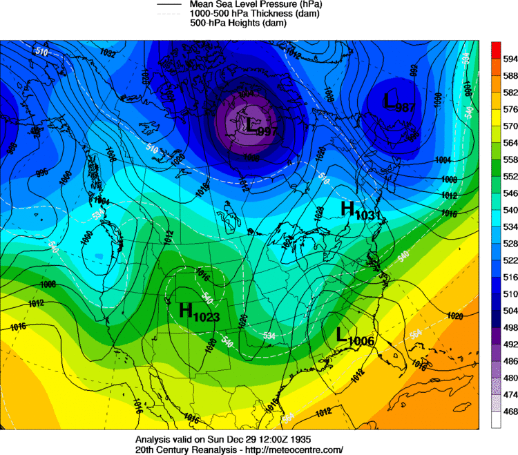
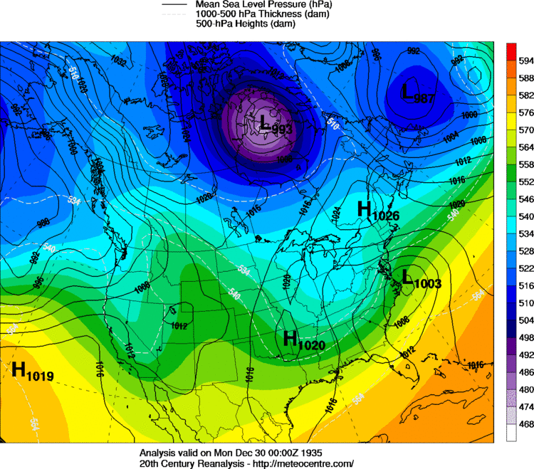
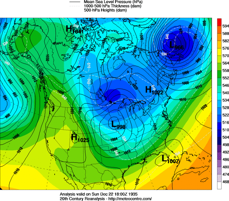
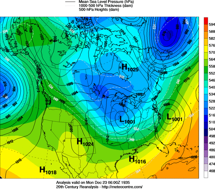
Webberweather53 link said:On this date in 1935, a classic, prolonged overrunning/Miller B event produced the 2nd major snowstorm in less than a week in central and eastern NC. As much as a foot of snow fell just west and southwest of Charlotte in southwestern NC and extreme upstate SC. A mix of rain, snow, sleet and freezing rain occurred from the Triangle area and points southeastward owards the south-central coastal plain with snow/sleet accumulations topping out around 3-6", while mostly rain fell in the extreme southern coastal plain, including Wilmington. Eventually, most areas south & east of Raleigh changed over to mainly snow overnight on the 29th as a sub 1000mb coastal low developed east of Hatteras. As many here are already well aware, this was only the tip of the iceberg in the winter of 1935-36, as a several more winter storms would hit the state in January & February, making 1935-36 one of the snowiest winters area-wide in much of North Carolina dating back to the late 19th century.
As one would expect from modern relationships amongst southeastern US wintry wx and high-latitude blocking, the first storm, a classic coastal Miller A, not all that dissimilar from its modern cousin in December 2010, featured a robust -AO/-NAO (& even north pacific blocking), while the 2nd system, Miller B/overrunning event, on December 28-29 was dominated by primarily in the north-northwestern Pacific blocking. (-WPO/-EPO)
SD link said:[quote author=Webberweather53 link=topic=60.msg3968#msg3968 date=1482961469]
On this date in 1935, a classic, prolonged overrunning/Miller B event produced the 2nd major snowstorm in less than a week in central and eastern NC. As much as a foot of snow fell just west and southwest of Charlotte in southwestern NC and extreme upstate SC. A mix of rain, snow, sleet and freezing rain occurred from the Triangle area and points southeastward owards the south-central coastal plain with snow/sleet accumulations topping out around 3-6", while mostly rain fell in the extreme southern coastal plain, including Wilmington. Eventually, most areas south & east of Raleigh changed over to mainly snow overnight on the 29th as a sub 1000mb coastal low developed east of Hatteras. As many here are already well aware, this was only the tip of the iceberg in the winter of 1935-36, as a several more winter storms would hit the state in January & February, making 1935-36 one of the snowiest winters area-wide in much of North Carolina dating back to the late 19th century.
As one would expect from modern relationships amongst southeastern US wintry wx and high-latitude blocking, the first storm, a classic coastal Miller A, not all that dissimilar from its modern cousin in December 2010, featured a robust -AO/-NAO (& even north pacific blocking), while the 2nd system, Miller B/overrunning event, on December 28-29 was dominated by primarily in the north-northwestern Pacific blocking. (-WPO/-EPO)
wxbell . Can't be beat . They a free trial period as wellHartselleWeather link said:Hey storm5 what paid site you getting your euro maps from. Thinking about signing up for the winter.
Let me guess, nothing like 12z , or warmer!?Shawn link said:Well 18z should be interesting here on future frames.

Let me guess, nothing like 12z , or warmer!?Tarheel1 link said:[quote author=Shawn link=topic=60.msg3977#msg3977 date=1482963582]
Well 18z should be interesting here on future frames.
Let me guess, nothing like 12z , or warmer!?Shawn link said:[quote author=Tarheel1 link=topic=60.msg3978#msg3978 date=1482963881]
[quote author=Shawn link=topic=60.msg3977#msg3977 date=1482963582]
Well 18z should be interesting here on future frames.
Webberweather53 link said:On this date in 1935, a classic, prolonged overrunning/Miller B event produced the 2nd major snowstorm in less than a week in central and eastern NC. As much as a foot of snow fell just west and southwest of Charlotte in southwestern NC and extreme upstate SC. A mix of rain, snow, sleet and freezing rain occurred from the Triangle area and points southeastward owards the south-central coastal plain with snow/sleet accumulations topping out around 3-6", while mostly rain fell in the extreme southern coastal plain, including Wilmington. Eventually, most areas south & east of Raleigh changed over to mainly snow overnight on the 29th as a sub 1000mb coastal low developed east of Hatteras. As many here are already well aware, this was only the tip of the iceberg in the winter of 1935-36, as a several more winter storms would hit the state in January & February, making 1935-36 one of the snowiest winters area-wide in much of North Carolina dating back to the late 19th century.
As one would expect from modern relationships amongst southeastern US wintry wx and high-latitude blocking, the first storm, a classic coastal Miller A, not all that dissimilar from its modern cousin in December 2010, featured a robust -AO/-NAO (& even north pacific blocking), while the 2nd system, Miller B/overrunning event, on December 28-29 was dominated by primarily in the north-northwestern Pacific blocking. (-WPO/-EPO)
Yeah should be another day 11 stormShawn link said:yeah cold push is stronger so far, system trying to get going back in texas. might not be a fail run by any means.
Shawn link said:yeah cold push is stronger so far, system trying to get going back in texas. might not be a fail run by any means.