Phil Connors
Member
January 2014 vibes?
Sent from my iPhone using Tapatalk
Sent from my iPhone using Tapatalk


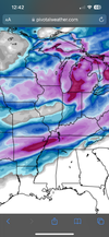
Band of precip from E Texas through ATL?Casual


That trend took SE PA to Southern NE out of snow accumulation
it's more than flurriesEuropean with some flurries in the midsouth area
Looks like a lot of the 1-3 inchers we used to get back in the 90s. They used to use the Cedartown to Cleveland line on a lot of the forecasts.it's more than flurries

Have to wonder if this pushes much further south there would have to be some Atlantic ignition there.
Ill take a 3" "dusting" all dayInteresting. It looks like flurries or a light dusting is back on the table for N Alabama for now
Biggest thing was getting the cold press in the east better and we've done that so far. The EURO also is getting closer and closer to stream separation. We are perfectly situated with precip just off the coast and plenty of time for it to drive north, especially for overrunning where those details won't be ironed out until 24-36 HRs out.
WAYYY moreit's more than flurries
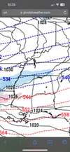
This look a little better in line with 12z gfs to anyone?
Perfect look at this lead time
This screams overrunning!This look a little better in line with 12z gfs to anyone?
Has never been off the table, but trends have it increasingInteresting. It looks like flurries or a light dusting is back on the table for N Alabama for now
Good flizzard potential at the very leastHas never been off the table, but trends have it increasing
this is what it says, it's from Chris Lisaukis of Eyes to the sky Weather, and he is very good at this stuff:Can't see post