packfan98
Moderator
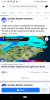
Allan Huffman’s call map.
That aligns closely with the latest RAP.
The NAM still bothers me to some point. It has increased QPF but it's still not anything worth wild (snow - half to 1" maybe). In a couple of hours we'll have a look at the 12z; hopefully it shows another increase.Looks like it increased totals by at least an inch. Euro looking better, and the other models are holding steady. NAM is out to lunch. I think at least 3 inches for my neck of the woods.
I don't feel great about the south side of the snow at all. Looks like it's going to be a tight gradient between accumulation and ending as a few flakes and I think I'm going to be on the ending as a few flakes side
Yep agree. Once I saw the HrrrRrR tick north with the main axis of accums, the writing was kind of on the wall for me. Models usually tend to see the delayed cooling around the 36-24 hour mark, thus adjusting the totals down across the southern areas. I still think a dusting look doable. Maybe an inch or so across the northern part of Wake.I don't feel great about the south side of the snow at all. Looks like it's going to be a tight gradient between accumulation and ending as a few flakes and I think I'm going to be on the ending as a few flakes side
The 0C line is north of 64 and around the 401 /us1 corridor on the Gfs now for wake . Been creeping north . Anyways , I may have to take away your pants bursting alert .I don't feel great about the south side of the snow at all. Looks like it's going to be a tight gradient between accumulation and ending as a few flakes and I think I'm going to be on the ending as a few flakes side


Looks like it’s raising temps for here as well. Biggest bust potential on the low side for southern wake south . Still thing northern wake north look good , could eat into accums though, 1-3 instead of the modeled 4-5 lol. We will see , 12 hours from now would be nowcasting time .FYI hrrr has been sneakily raising temps across the area the past several runs. Most of TN has gone from 2-4 to a dusting...
Hopefully we don’t see the same for you guys.
View attachment 68407View attachment 68408
Looks like a typical setup where the winners win around here. MehYep agree. Once I saw the HrrrRrR tick north with the main axis of accums, the writing was kind of on the wall for me. Models usually tend to see the delayed cooling around the 36-24 hour mark, thus adjusting the totals down across the southern areas. I still think a dusting look doable. Maybe an inch or so across the northern part of Wake.
Looks like a typical setup where the winners win around here. Meh

Yeah on one hand I have some optimism that we can get some banding going which may allow us to over perform but the ticking warmer and north with the better fgen makes me think that won't happenYeah I'm more nervous around here. Theres that precip minimum popping up over my area and then any warming temps just hurt us bigtime in this setup.
Life south of HWY 70/64 is rough.... life south of HWY42 is rougher.Looks like a typical setup where the winners win around here. Meh
Waiting for MYFRO to post that sexy gif of the future cast HRRR paste bomb


Indeed I started to believe yesterday and thought maybe we could get 2-3 maybe 4. Unfortunately reality shows againLife south of HWY 70/64 is rough.... life south of HWY42 is rougher.
FYI hrrr has been sneakily raising temps across the area the past several runs. Most of TN has gone from 2-4 to a dusting...
Hopefully we don’t see the same for you guys.
View attachment 68407View attachment 68408
I wouldn't get too excited if I were some of the areas in eastern nc. It's been shifting east like crazy that last couple of runs.
That is where I was at on the 06z run. Now it shifted over your way. I don't like that trend for many people.I'm danger close to that Western limit, and in this setup, that is NOT GOOD!
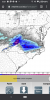
I certainly do think there could be a cutoff west of Forsyth, Davidson, and Randolph county. The RGEM has it:I wouldn't get too excited if I were some of the areas in eastern nc. It's been shifting east like crazy that last couple of runs.

I wouldn't get too excited if I were some of the areas in eastern nc. It's been shifting east like crazy that last couple of runs.
The 6.6” is basically over my place. Jackpot! modernweenie
It's good to see the NW trend still alive and kicking in right on cue.

Yeah, I feel a little more comfortable here in Durham than I would at my parents’ in Greensboro. Then again, climo being climo, I probably shouldn’t since it’ll probably take forever to changeover here while it hammers in the Triad for hours. ?I'm danger close to that Western limit, and in this setup, that is NOT GOOD!