ATL ?

It does, and it’s slowerI’m waiting for the “Nam looks more amped” comment
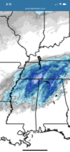
man this setup really interests me with that comma head/deformation zone, shows up nicely on the euro, that’s what I’m banking on here and what many should watch, with a strengthening and formidable 1000/999mb mid latitude cyclo
I wouldn’t consider Carrollton to be ATL metro. But I do like the trends.2-3" for the Atlanta metro ? Wow.
Yeah hrrr would be fine with me. A decent rain event then daytime snowI mean, it's stil showing snow here, so take it as a win.
Carrollton to Dallas to Canton looks like a possibility.I wouldn’t consider Carrollton to be ATL metro. But I do like the trends.
Told you.With these Trends I think tomorrow even the upstate will be in the ballgame. The dynamics of this thing is insane
Sent from my SM-A526U using Tapatalk


Honestly that’s a look that could support a elevated supercell or 2, at least would be some pretty strong elevated thunderstorms with this look with a hail threat, hard to find a uncontaminated sounding tho in that mess@Myfrotho704_ those big thunderstorms that develop around wake on the HRRR does it look like possible hailers in those or anything like that? They looked intense low key


That sounds right because I’m about 10 miles on the wrong side of it.Carrollton to Dallas to Canton looks like a possibility.
2m temps on 00z NAM (12km model) is significantly colder Sunday morning. Around 9am it's 57 here, 18z NAM it was still 66 at the same timeframe. I think this is the first NAM run in sometime where it keeps us in the 50s tomorrow morning into the early afternoon. Whether we see a flake here or not I don't care, I'm beyond ready for winter-like temps to return. The sooner the better so I hope the quicker cooldown post-frontal passage is right.I wouldn’t consider Carrollton to be ATL metro. But I do like the trends.
It isI’m waiting for the “Nam looks more amped” comment
Could be thunder snow with that band in vaHonestly that’s a look that could support a elevated supercell or 2, at least would be some pretty strong elevated thunderstorms with this look with a hail threat, hard to find a uncontaminated sounding tho in that messView attachment 100895View attachment 100896View attachment 100897


I have zero meteorological basis for saying this but the dynamics of this system gives me Suoerstorm ‘93 vibes, albeit at a much smaller scale.Could be thunder snow with that band in va
I’m so down bad that I would take thatProbably more likely to see thundersleet and graupel than snow on the backend in NC.
I think you need to create a forecast map of your thoughts. You’ve been right on so far.Probably more likely to see thundersleet and graupel than snow on the backend in NC.

Not even close to being done in northeast AL at that point. Sitting in the sweet spot in Etowah!nam buries us
I don’t know if I would call it realistic, but certainly puts me in a much more favorable position. I would like to see this trend continue with the other 00z models. May just be an outlier.This looks far more realistic View attachment 100900
I mean more realistic, as in more amped, the NAM has been the outlier by itself until nowI don’t know if I would call it realistic, but certainly puts me in a much more favorable position. I would like to see this trend continue with the other 00z models. May just be an outlier.
Wont take much of a south move to be really big in NC.
Thats why im saying a little more south and lots in NC get a big one.This looks far more realistic View attachment 100900
 3K looks like the HRRR
Please verify for us. Also, will be a lot of black ice on the overpass with temps crashing mid-upper 20’s.nam buries us
I hope I get time between now and late tomorrow. If I do one it wouldn’t be til tomorrow evening.I think you need to create a forecast map of your thoughts. You’ve been right on so far.