-
Hello, please take a minute to check out our awesome content, contributed by the wonderful members of our community. We hope you'll add your own thoughts and opinions by making a free account!
You are using an out of date browser. It may not display this or other websites correctly.
You should upgrade or use an alternative browser.
You should upgrade or use an alternative browser.
Jan. 17-18, 2026 SE Winter Weather Threat
- Thread starter RBR71
- Start date
Bigedd09
Member
In all seriousness. It’s great to still be tracking a threat where short range models start coming into play
Sent from my iPhone using Tapatalk
Sent from my iPhone using Tapatalk
- Joined
- Jan 2, 2017
- Messages
- 1,566
- Reaction score
- 4,279
Forevertothee
Member
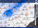
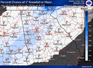
Also be aware that is just through 7am on Sunday. If you look west to Atlanta to Athens the % are higher.nws gsp probabilities as of this morning. hopefully we get some upticks
View attachment 183656
these next 7 days are a doozy of a forecast around here even after figuring out any snow potential. big temp differences Mon and beyond.
There are still too many things I can point at and go "ehhhh... idk man" to publicly forecast accumulating snow around here yet. Timing isn't great, precip isn't a guarantee, thermos are meh with marginal cold air source AND you are counting on precip not starting earlier than modeled and beating likely slower than modeled cold air to the spot. 6z NAM12 looks like a lot of "column crashing" to get it done. It can work, but it scares me. Now we see who wins between the GFS/NAM camp and the Euro/AIs camp. My gut says the NAM probably is closer to reality but I just would like to see some sort of indication that could be the case from the dry models.
There are still too many things I can point at and go "ehhhh... idk man" to publicly forecast accumulating snow around here yet. Timing isn't great, precip isn't a guarantee, thermos are meh with marginal cold air source AND you are counting on precip not starting earlier than modeled and beating likely slower than modeled cold air to the spot. 6z NAM12 looks like a lot of "column crashing" to get it done. It can work, but it scares me. Now we see who wins between the GFS/NAM camp and the Euro/AIs camp. My gut says the NAM probably is closer to reality but I just would like to see some sort of indication that could be the case from the dry models.
Last edited:
iGRXY
Member
There's not much use for it anyways. The ONLY reason I even am giving it credence right now is strictly from a synoptic standpoint. This is an overrunning setup so when dealing with that kind of setup you tend to have more moisture showing up all the way to hour 0. Also if yo look at all these models, they have the SER pretty pronounce (it just isn't highlighted in the pretty yellow color on the maps). That leads me to believe that we will at least have more moisture availability. I'm still not sold on snow outside of the mountains until we continue to see consistent runs showing because of the cold air issue. If things change synoptically at this point, then yes the GFS is likely wrong with its moisture depiction.I’ll say this if the GFS loses this battle Im not even gonna pay it any attention anymore.
WEATHERBOYROY
Member
At this range it can be pretty bad, but sometimes at short range it does well. It was the only model within 12 hrs I saw that had accumulating precip making it to the ground in Birmingham in 2014 snowmageddon.No. Probably the worst model out there
Sent from my iPhone using Tapatalk
Webberweather53
Meteorologist
these next 7 days are a doozy of a forecast around here even after figuring out any snow potential. big temp differences Mon and beyond.
There are still too many things I can point at and go "ehhhh... idk man" to forecast accumulating snow around here. Timing isn't great, precip isn't a guarantee, thermos are meh with marginal cold air source AND you are counting on precip not starting earlier than modeled and beating likely slower than modeled cold air to the spot. 6z NAM12 looks like a lot of "column crashing" to get it done. It can work, but it scares me. Now we see who wins between the GFS/NAM camp and the Euro/AIs camp. My gut says the NAM probably is closer to reality but I just would like to see some sort of indication that could be the case from the dry models.
If the precip onset is earlier than forecast (as it often is in these setups) that also likely means everything is shifted north because where the precip crosses and is lifted over the boundary is to the north.
iGRXY
Member
I'm honestly sitting in the "Wait until the Hi-Res models get in range" camp now. Not really looking at the GFS and EURO or AI models much more at this point. Too many small details that have to get ironed out that really on the short range CAMs are going to see.these next 7 days are a doozy of a forecast around here even after figuring out any snow potential. big temp differences Mon and beyond.
There are still too many things I can point at and go "ehhhh... idk man" to publicly forecast accumulating snow around here yet. Timing isn't great, precip isn't a guarantee, thermos are meh with marginal cold air source AND you are counting on precip not starting earlier than modeled and beating likely slower than modeled cold air to the spot. 6z NAM12 looks like a lot of "column crashing" to get it done. It can work, but it scares me. Now we see who wins between the GFS/NAM camp and the Euro/AIs camp. My gut says the NAM probably is closer to reality but I just would like to see some sort of indication that could be the case from the dry models.
nws gsp probabilities as of this morning. hopefully we get some upticks
View attachment 183656
And it’s only through 7 am Sunday
Sent from my iPhone using Tapatalk
KFFC Atlanta:
Updated at 606 AM EST Thu Jan 15 2026
- There is a potential for a winter storm system across
portions of the Southeast Saturday Night into Sunday but
confidence remains very LOW on location/impacts if any.
Updated at 606 AM EST Thu Jan 15 2026
- There is a potential for a winter storm system across
portions of the Southeast Saturday Night into Sunday but
confidence remains very LOW on location/impacts if any.
rburrel2
Member
I haven’t seen any data on where ai models are better at qpf. I think that might be the thing here. They locked at 5h, but might be a little stingy on precip shield
HailCore
Member
Webberweather53
Meteorologist
I'm honestly sitting in the "Wait until the Hi-Res models get in range" camp now. Not really looking at the GFS and EURO or AI models much more at this point. Too many small details that have to get ironed out that really on the short range CAMs are going to see.
Even if the Euro/EPS suite verifies, I still have concerns about the cold air getting here in time in the Carolinas. Can’t be too dry here because a lot of our cooling to make the column cold enough to snow is going to be dynamically driven.
Mahomeless
Member
1000% agreed….there are major BL issues on the Euro.Even if the Euro/EPS suite verifies, I still have concerns about the cold air getting here in time in the Carolinas. Can’t be too dry here because a lot of our cooling to make the column cold enough to snow is going to be dynamically driven.
With the SREF and NAM coming in line with the GFS, I am all in with this being a major storm for AL/GA up through the far western sections of the Carolina’s.
As a contractor for inclement weather, we watch the models but do not buy into them until we see the Euro on board. We keep the equipment ready for whatever happens but definitely not excited yet. I have seen GFS show a torm all the way within 24 hours and then cave to Euro. If GFS was right, we would average 50 inches a year here for me. It's right in summertime, but in winter it's just fun to watch.I’ll say this if the GFS loses this battle Im not even gonna pay it any attention anymore.
I can remember 30 years ago when the GFS would sniff it out 15 days away, only to lose it, but bring it back with a week or less out. Euro would show a storm 10 days away and verified 9 out of 10 times. They are nowhere close to where they were. However Euro is still the King
That felt like a warning shot from GEFS. It tends to suck you in with a pretty snowfall ensemble mean bc you don’t get a lot of variation between its members. However I do believe there will be enough precip north and west of what the euro is showing now. There’s just not enough cold dry air to cause a sharp precip gradient the way the AI models are showing it especially. You’re going to see heaviest precip rates towards the coast and as we get a little closer to verification in the next day or two the precip contours will begin to race inland. They always do. My lean is that many of you guys will end up seeing some snow fall. Overall I just like the axis of this system even though the cold is a little later than I’d like to see.
rburrel2
Member
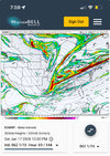
06z icon and rgem made massive jumps towards the gfs. Really hoping they make another small jump in that direction at 12z.
To me, all the models look decent with the set up but most of them don’t crank the precip up in time.
The gfs gets it going much earlier across the mid south.
Look at the comparison between the gfs and euro early on… they’re near identical. But the gfs has busted out precip in LA/MS/AL and the euro is bone dry.
The only real difference is the ridging out in front on the gfs is a little better. I wouldn’t bet against that, imo.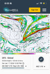


rusrius
Member
The National Weather Service in Columbia now has a 30% chance of snow for Sunday night thru lunch Monday so there's that.
CNCsnwfan1210
Member
06z icon and rgem made massive jumps towards the gfs. Really hoping they make another small jump in that direction at 12z.
To me, all the models look decent with the set up but most of them don’t crank the precip up in time.
The gfs gets it going much earlier across the mid south.
Look at the comparison between the gfs and euro early on… they’re near identical. But the gfs has busted out precip in LA/MS/AL and the euro is bone dry.
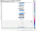
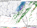
The only real difference is the ridging out in front on the gfs is a little better. I wouldn’t bet against that, imo. View attachment 183665View attachment 183666
Just a little more tilt on the GFS made the difference there imo
Sent from my iPhone using Tapatalk
rburrel2
Member
Furthermore, the euro ai matches the gfs perfectly at this timestamp in regards to the ridging out front.
The euro ai does not have the sharpening vort at the bottom of the trough like the gfs/euro have though.
Combine the euro/gfs vort orientation with the gfs/euro ai ridging out front and you have the gfs solution.
The euro ai does not have the sharpening vort at the bottom of the trough like the gfs/euro have though.
Combine the euro/gfs vort orientation with the gfs/euro ai ridging out front and you have the gfs solution.
TigerSnow
Member
What time will the models start sampling our piece of energy? Maybe that will shed some more light on model agreement.
iGRXY
Member
iGRXY
Member
It's already on land now in CanadaWhat time will the models start sampling our piece of energy? Maybe that will shed some more light on model agreement.
iGRXY
Member
It's part of the short range CAM models that will need to be used to pick up on the FGEN WAA forcing that'll drive the overrunning precip.What is that model
Sent from my iPhone using Tapatalk
rburrel2
Member
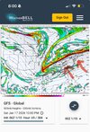
it’s getting the tilt from the higher heights out front as seen here…Just a little more tilt on the GFS made the difference there imo
Sent from my iPhone using Tapatalk
The euro ai also has these higher heights, in fact, even more so!
I think the euro is wrong with the lower heights in this region and it can be tossed, my two cents.
And the hope is the euro/gfs is right with the vortmax at the bottom and the euro ai is too coarse to see that.
Ok I understand that. However, as depicted by the GFS and the other amped models, this is a dynamically driven trough that is creating the dynamics not by typical WSW to slightly NNE up glide and advection as seen by our typical overrunning events. Even the Mets at GSP and Raleigh note this on their AFDs. If the GFS is right, we will be dealing with rain here in central NC followed by a dynamically driven column crash, not by just warm air advection. Maybe you can explain this better, because this looks nothing like our historical overrunning events.Even if the Euro/EPS suite verifies, I still have concerns about the cold air getting here in time in the Carolinas. Can’t be too dry here because a lot of our cooling to make the column cold enough to snow is going to be dynamically driven.
iwantsouthernsnow123
Member
the siren song of advoca
RRFS has certainly hinted at thisI still think there’s going to be a more expansive precip shield on the NW side of this. There always is with overrunning. We aren’t in the short range models wheelhouse yet. That’s another 24-48 hours from now. I think you’ll see that moisture isn’t going to be the issue with this storm. It will continue to be the temps.
you also have to hope that it isn't an in-between solution of the NAM/GFS and the Euro, because marginal 2m's are gonna need some dynamic cooling and a further northwest precip shield that remains light may not cut it
- Joined
- Jan 23, 2021
- Messages
- 4,602
- Reaction score
- 15,197
- Location
- Lebanon Township, Durham County NC
Even in the best case scenario of the GFS, the second it stops snowing is the second it starts melting.you also have to hope that it isn't an in-between solution of the NAM/GFS and the Euro, because marginal 2m's are gonna need some dynamic cooling and a further northwest precip shield that remains light may not cut it
iGRXY
Member
Ding Ding Ding. I am still not convinced on the snow east of the mountains. I do feel like the precip will be there. But how much and it's rate is a big thing in this. We need dynamic cooling to get the snow to the ground.you also have to hope that it isn't an in-between solution of the NAM/GFS and the Euro, because marginal 2m's are gonna need some dynamic cooling and a further northwest precip shield that remains light may not cut it
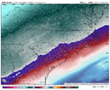
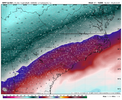
The NAM for example does at least give hope that there could be snow along and north of 85 simply by looking at the midlevel temps as precip arrives
TigerSnow
Member
We’ve seen these marginal events many times in the Charlotte area. They rarely work out for us. With the precip looking light in that area I don’t see how this works out. I can understand how the gfs looks good but the Euro has been correct in these time and time again. I feel like this will be a light rain event in my area. Without the blocking high north we are in trouble. We even have trouble at times with a strong high in place.
quick hit too... i am talking myself out of this one this morning lolEven in the best case scenario of the GFS, the second it stops snowing is the second it starts melting.
rburrel2
Member
Nothing wrong with a quick hit. Give me .2-.3 of liquid falling from 5am-9am over the upstate. That would yield a nice 1-3 inch snow. I’m not concerned about temps here. Soundings look great. Eastern NC will have the temp issuesquick hit too... i am talking myself out of this one this morning lol
My first cup of coffee, Atlanta area thoughts:
The NAM, with its early and robust amplification of the tail end of our long-wave trough, is illustrative of why, assuming the globals have a good handle on the overall setup, areas far to the west of the EURO and AI solutions can trend either way right up to inside 24 hours from go time. Even small perturbations in the orientation of this feature make large, sensible differences. It's a relatively small-scale feature subject to changes even in the very short term.
The 06Z GFS ensemble suite is disappointing after such robust agreement at 00Z and is a nod to other modeling that concentrates the system to our east.
I also have similar concerns as Eric regarding the boundary level profiles for my area east of Atlanta, should the more western solutions verify. low level cold air advection from the NW is always slower to arrive here and holds the potential for heartbreak, particularly if precip rates are meager. Been there, done that.
Absent a total collapse of modeled chances over the next 24 hours, we'll just have to wait until daybreak Saturday to have a solid idea of what is likely to occur.
Just have to have good enough rates if we are to be 33-37F at onset around here. Still reason to doubt thatNothing wrong with a quick hit. Give me .2-.3 of liquid falling from 5am-9am over the upstate. That would yield a nice 1-3 inch snow. I’m not concerned about temps here. Soundings look great. Eastern NC will have the temp issues


