weird euro run. looked decently improved @72 and i almost commented on it. i wasn't expecting another precip whiff from what i saw at h5
-
Hello, please take a minute to check out our awesome content, contributed by the wonderful members of our community. We hope you'll add your own thoughts and opinions by making a free account!
You are using an out of date browser. It may not display this or other websites correctly.
You should upgrade or use an alternative browser.
You should upgrade or use an alternative browser.
Jan. 17-18, 2026 SE Winter Weather Threat
- Thread starter RBR71
- Start date
Like I mentioned, models have gotten better over the last 5 years. Much less run-to-run variation inside of 84 hours. Unfortunately, like Atlanta, Toccoa will likely not see any measurable snowfall from this event.Generally its quite the opposite, you want those trends within this timeframe. NW tick often happens. FFC NWS mentions that this will not be really figured out possibly until 24-48 hours till.
I want snow, but at some point we have to be realistic here. The ECMWF/AIFS are the gold standard in NWP. Doesn't mean that they're perfect, but expecting such drastic changes in such a short period is merely wishcasting.
When it is GFS vs the world, the world wins 99/100 times.
iwantsouthernsnow123
Member
Does the phasing look off to you? Like almost like euro isnt handling things well?weird euro run. looked decently improved @72 and i almost commented on it. i wasn't expecting another precip whiff from what i saw at h5
NWS LIX has just added a 20% chance of snow Saturday night for my location. Nice to see this in the forecast now!
Does the phasing look off to you? Like almost like euro isnt handling things well?
It had ticked west anyways (barely) as shown by prior comments. I do have to side with potential modeling differences being the problem here.
NorthGaWinter4
Member
I don't think Atlanta will receive measurable snowfall from this event, FWIW. Best chance for snowfall will be in the Carolinas.I don't think Atlanta will receive measurable snowfall from this event, FWIW. Best chance for snowfall will be in the Carolinas.
i 100% disagree
SegTindo
Member
Wouldn't that legitimately just shut down the entire Atlanta metro for at least a day before a warmup would melt some of the accum?
Footnote, if it doesn't melt all of it, then it's going to stay for 4 days due to a cold spell lol
Pretty much the entire southeast
Sent from my iPhone using Tapatalk
Where is your model?Like I mentioned, models have gotten better over the last 5 years. Much less run-to-run variation inside of 84 hours. Unfortunately, like Atlanta, Toccoa will likely not see any measurable snowfall from this event.
I want snow, but at some point we have to be realistic here. The ECMWF/AIFS are the gold standard in NWP. Doesn't mean that they're perfect, but expecting such drastic changes in such a short period is merely wishcasting.
When it is GFS vs the world, the world wins 99/100 times.
Running now, will share the results when availableWhere is your model?
what's the reasoningI don't think Atlanta will receive measurable snowfall from this event, FWIW. Best chance for snowfall will be in the Carolinas.
i 100% disagree
NorthGaWinter4
Member
How have we ran out of time for the NW trend to continue? I’m very curious on your theoryEveryone wants this NW trend to continue, we've just run out of time for any further substantial NW trend IMO. Especially after seeing the 00z AIFS/IFS outputs.
If we in Atlanta were seeing these model outputs at 144hrs, I'd be excited. Unfortunately, we're about 84hrs out from the 'event'. And models have gotten better over the last 5 years.
accu35
Member
As Webb mentioned earlier, we may have little more NW trend up until go time.
Well something gotta give. Got 2 models that are 300 miles apart.As Webb mentioned earlier, we may have little more NW trend up until go time.

there's not really any phasing with this to speak of. i just thought the structure of the shortwave looked better and was surprised it didn't bear fruit. i wouldn't be shocked if it's noise and the eps improvesDoes the phasing look off to you? Like almost like euro isnt handling things well?
As Webb mentioned earlier, we may have little more NW trend up until go time.
There's nothing preventing it until we get better data which won't happen for at least 6-12 hours I assume, considering the area of interest.
However as TheBatman mentioned, something's got to give soon and it'll happen quick lol
iwantsouthernsnow123
Member
I have noticed that euro doesn't push as much southern stream energy up as the other models which leads me to believe maybe it could be heading that way. The positive tilt worries me but it may not be the worst thing ever.there's not really any phasing with this to speak of. i just thought the structure of the shortwave looked better and was surprised it didn't bear fruit. i wouldn't be shocked if it's noise and the eps improves
Guys 12z models today gonna be huge!! Another piece of the puzzle will start to come in as the data is ingested to the model systems. Just every chill.
NorthGaWinter4
Member
I’m not a certified met but have been watching weather for almost a decade at this point. The NW trend has only failed once (last year) also in overrunning events the precip field has always over performed. Also almost every major model ensembles has at least a dusting for the Atlanta metrowhat's the reasoning
Conventional weather models tend to have a 'NW trend' component, especially between 84 and 144hrs. Usually that starts to slow from a strong NW trend to wobbles inside of 84 hours.How have we ran out of time for the NW trend to continue? I’m very curious on your theory
New generation models (AIFS/AIFS-ENS/WeatherNext2/Pangu, etc) have very little variation inside of 84 hours, especially in terms of strong trends in one direction.
I mean, look at the last 4 runs of the AIFS. Just small wobbles. This is what I generally expect over the next 3 days -- the new generation models will continue to have small wobbles while conventional models fall into line with what they are showing. This has been the case for the last 2-3 years.
I am a lead weather model engineer for a company that focuses on predicting snow around the world. I live and breathe this stuff every day.
As bad as I want snow, I can't deny what I am seeing here.


Euro Ensemble ticks west but this is becoming confusing with the high discrepancy between AI/Phys.
iwantsouthernsnow123
Member
Since we're going to bring up AIFS specifically. Thought it was necessary to add GFS AI as well rather than just using 1 AI model. I get you're a model developer but at the same time can't just look at 1 model and call it a day.Conventional weather models tend to have a 'NW trend' component, especially between 84 and 144hrs. Usually that starts to slow from a strong NW trend to wobbles inside of 84 hours.
New generation models (AIFS/AIFS-ENS/WeatherNext2/Pangu, etc) have very little variation inside of 84 hours, especially in terms of strong trends in one direction.
I mean, look at the last 4 runs of the AIFS. Just small wobbles. This is what I generally expect over the next 3 days -- the new generation models will continue to have small wobbles while conventional models fall into line with what they are showing. This has been the case for the last 2-3 years.
I am a lead weather model engineer for a company that focuses on predicting snow around the world. I live and breathe this stuff every day.
As bad as I want snow, I can't deny what I am seeing here.
View attachment 183603
Attachments
were the majority of these NW trends from actual low pressure systems (which im well aware of) or just an expansive precipitation field instead?I’m not a certified met but have been watching weather for almost a decade at this point. The NW trend has only failed once (last year) also in overrunning events the precip field has always over performed. Also almost every major model ensembles has at least a dusting for the Atlanta metro
iwantsouthernsnow123
Member

accu35
Member
EPS looks better then the OP
accu35
Member
That’s the 0z gfs from earlier
appreciate your expertise. hard to argue against any of that. have you noticed any storm modes that are harder on the ai models?Conventional weather models tend to have a 'NW trend' component, especially between 84 and 144hrs. Usually that starts to slow from a strong NW trend to wobbles inside of 84 hours.
New generation models (AIFS/AIFS-ENS/WeatherNext2/Pangu, etc) have very little variation inside of 84 hours, especially in terms of strong trends in one direction.
I mean, look at the last 4 runs of the AIFS. Just small wobbles. This is what I generally expect over the next 3 days -- the new generation models will continue to have small wobbles while conventional models fall into line with what they are showing. This has been the case for the last 2-3 years.
I am a lead weather model engineer for a company that focuses on predicting snow around the world. I live and breathe this stuff every day.
As bad as I want snow, I can't deny what I am seeing here.
View attachment 183603
850mb temps for the last 6 runs of the EPS centered on Saturday evening. If I was a betting man I would put the house on ticking west again at 12z.

iwantsouthernsnow123
Member
Weird, says AI GFS but it definitely is GFS. Probably just didnt load properly.That’s the 0z gfs from earlier
Nope, across the board, the AIFS/AIFS-ENS is the best publicly-available model suite available currently. AIGFS is quite a bit worse -- on par with the conventional ECMWF-IFS.appreciate your expertise. hard to argue against any of that. have you noticed any storm modes that are harder on the ai models?
There will certainly be cases where the ECMWF data assimilation techniques probablistically get it 'wrong' which would impact all downstream models (ECMWF-IFS, AIFS, EPS, AIFS-ENS, GRAF).. but most of the time, ECMWF has superior data assimilation techniques. And, typically, if there are issues with the ECMWF DA, you'd see divergence between the ECMWF-based/initialized models and models that use different DA (GFS, ICON, CMC, UKM).
In this case, the GFS/AIGFS are on an island of their own.. so this makes me think that there could be data assimilation issues with GFS.
iwantsouthernsnow123
Member
RRFS generally agrees with GFS. It seems like AIFS, especially euro and euro AI appears to be struggling making use of the southern stream while some other models are making rather practical use out of it. Obviously RRFS long range is questionable but the general phase is similar to GFS and Euro just makes a lot of use out of the southern jet.Nope, across the board, the AIFS/AIFS-ENS is the best publicly-available model suite available currently. AIGFS is quite a bit worse -- on par with the conventional ECMWF-IFS.
There will certainly be cases where the ECMWF data assimilation techniques probablistically get it 'wrong' which would impact all downstream models (ECMWF-IFS, AIFS, EPS, AIFS-ENS, GRAF).. but most of the time, ECMWF has superior data assimilation techniques. And, typically, if there are issues with the ECMWF DA, you'd see divergence between the ECMWF-based/initialized models and models that use different DA (GFS, ICON, CMC, UKM).
In this case, the GFS/AIGFS are on an island of their own.. so this makes me think that there could be data assimilation issues with GFS.
EPS didn't really improve with regards to precipitation amounts

CMC Ensemble did, but it is localized more to southeastern GA.

I unfortunately think the initial lead wave the GEFS is horribly on its own with (and @ F+054 it's doing this? Jesus).
It's what leads to that neutral/negative tilt quickly as opposed to the positive tilt through GA.
Should be an interesting study to see if the Euro AI can handle these setups. Here is the last ten runs of 24hr precip ending now.

this is heavy stuff. reading your findings gives me a sense of, if the aifs is locked in, then why even bother with anything elseNope, across the board, the AIFS/AIFS-ENS is the best publicly-available model suite available currently. AIGFS is quite a bit worse -- on par with the conventional ECMWF-IFS.
There will certainly be cases where the ECMWF data assimilation techniques probablistically get it 'wrong' which would impact all downstream models (ECMWF-IFS, AIFS, EPS, AIFS-ENS, GRAF).. but most of the time, ECMWF has superior data assimilation techniques. And, typically, if there are issues with the ECMWF DA, you'd see divergence between the ECMWF-based/initialized models and models that use different DA (GFS, ICON, CMC, UKM).
In this case, the GFS/AIGFS are on an island of their own.. so this makes me think that there could be data assimilation issues with GFS.

iwantsouthernsnow123
Member
I get AIFS is definitely advancing but I'm not convinced there isn't any fail modes. Can't forget what happened last yearthis is heavy stuff. reading your findings gives me a sense of, if the aifs is locked in, then why even bother with anything else
Sampling not long ago appears to look generally better for the south
the siren song of advocating for a nw trend is alluring but hard to argue against bouncycorn's thesis. just gotta live through it to find outI get AIFS is definitely advancing but I'm not convinced there isn't any fail modes. Can't forget what happened last year
Sampling not long ago appears to look generally better for the south
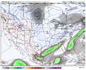
Some eye-candy for those that still have hope: the 3z SREFs

EPS didn't really improve with regards to precipitation amounts
Roxboro was similar but just to your east in E NC had an increase, especially coastal areas. E SC/SE GA had a moderate increase to the best run yet, which is a surprise to me as I had expected a NW trend. There was actually a bit of a SE trend from 18Z. I still think the amounts are overdone considering borderline temps.

Members:

