Yeah the more it can get elongated and sheared as it's moving through the plains the better for us. If you could take and average out the 0z and 12z euros we'd really have something hereUltimately, don’t we need to simply hope for a less strong and consolidated energy, so that it does not tilt negative so soon?
-
Hello, please take a minute to check out our awesome content, contributed by the wonderful members of our community. We hope you'll add your own thoughts and opinions by making a free account!
You are using an out of date browser. It may not display this or other websites correctly.
You should upgrade or use an alternative browser.
You should upgrade or use an alternative browser.
Wintry Jan 15-16 Winter Storm Discussion & Obs
- Thread starter SD
- Start date
iGRXY
Member
The placement of that LP is also going to be steering our 850 and 700 mb LP as well so the track of the low is absolutely important IMO. If it can't come as far north as the GFS and EURO are showing right now, then your upper level tracks are also going to be shifted south.I haven't looked at it much other than the pretty maps on here, but if the CAD isn't retreating then I kind of agree with what Allan Huffman said on Twitter that he doesn't buy the low riding that far inland with that strong of a CAD in place. It seems to be in a good spot off of SC then goes due north into the NC coastal plain. That has to be an odd track right? I want to see this thing just as modeled for GA and SC but then move ne of the NC coast and dump 6-10 all the way from ATL to RDU. But that may be wishcasting idk
Blue_Ridge_Escarpment
Member
Hour 51 18Z NAM energy out west is more consolidated and stronger.
- Joined
- Jan 2, 2017
- Messages
- 1,568
- Reaction score
- 4,283
This right here will be watched closely!It’s all about the 925 millibar level! Seen many a sleet and ZR storm with 2m temps in low to mid 20s and a pesky +1 or + 2 degrees at 925
SPC Hourly Mesoscale Analysis
www.spc.noaa.gov
NBAcentel
Member
NAM looks to backed off the relentless digging trend that all models have showed, and it’s colder
Cary_Snow95
Member
It’s interesting. The Baja low on the NAM is further NE. Might help to sheer the wave a bit as it moves east
iGRXY
Member

It's funny seeing the Nam correct this first vort over us back to the west and southwest in the short range.
iGRXY
Member
Nam Definitely looks a little more sheared at 66 with a bit stronger cold push in SC at 66.
Blue_Ridge_Escarpment
Member
Lol GSP. We can’t find a model any more that doesn’t have warning criteria snow so we are picking out individual ensemble members.
All of the “snow” in atlanta is probably sleet
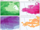
Per 12Z Euro for Atlanta: ~0.50” of qpf is initially with 850s at or slightly colder than 0C. So, if 10:1, that would be ~5” of snow to start keeping in mind 2M temps are 27-28 F:


The next 0.50” of qpf is with 850s mainly 0 to +3, which would typically mean per history when there’s a strong wedge mainly sleet though there would probably also be some ZR. Temps remain 27-28. I’d call this very roughly 1.5” of sleet and ~0.10” of ZR on top of the 5” of snow:


Lastly, it changes back to mainly snow on the backside with 850s dropping back to mainly the 0C to -3C range and ~0.20” of qpf along with 29-30 F. So, I’d call that ~2” of snow:


So, the 12Z Euro has for Atlanta ~1.2” of qpf falling with temps mainly 27-30 F translating to roughly 7” of snow, 1.5” of sleet, and 0.10” of ZR. That would mean 8.5” of total accumulation, which would be the heaviest since the 10” of January of 1940 and 3rd heaviest total accumulation on record. If this were to fall as almost all sleet, it would be near the 4”+ of sleet that Atlanta got in 2/1979 and 1/1988 and would be an absolute mess based on my experiencing those two storms. That would actually likely make it a more impactful storm imo than if it were to be the Euro output of 7” of snow, 1.5” of sleet, and 0.10” of ZR.
Last edited:
It's not impossible but with the lack of a good -nao its hard to find a smoking gun for a SE trend. The good thing is even with the bad runs its still very possible our area gets a pretty decent shot of fgen/waa/upglide as this are getting underway and we see a period of snow on the front. Models typically underdo that process so even if this ends up being underwhelming here and buries areas to the west we could still get a nice 3-4 hour event before we get into the mixed messWhich is beyond reasonable given we’re still 90+ hours to it tilting
iGRXY
Member

This is how the NAM ends. It closes at 78 and is strengthening at 84.
accu35
Member
I think the Nam was headed for some fun stuff if it was to keep going
packfan98
Moderator
Agreed. At the very least, there will be a large portion of the SE under Winter Storm Warnings for the first time this winter. For my area, I call a good winter if I get two WSW's.It's not impossible but with the lack of a good -nao its hard to find a smoking gun for a SE trend. The good thing is even with the bad runs its still very possible our area gets a pretty decent shot of fgen/waa/upglide as this are getting underway and we see a period of snow on the front. Models typically underdo that process so even if this ends up being underwhelming here and buries areas to the west we could still get a nice 3-4 hour event before we get into the mixed mess
accu35
Member
Is it 0z tonight were the Nam comes in sight in the SE?
What's the best short range model to pick that up the earliest usually?It's not impossible but with the lack of a good -nao its hard to find a smoking gun for a SE trend. The good thing is even with the bad runs its still very possible our area gets a pretty decent shot of fgen/waa/upglide as this are getting underway and we see a period of snow on the front. Models typically underdo that process so even if this ends up being underwhelming here and buries areas to the west we could still get a nice 3-4 hour event before we get into the mixed mess

Closed at 543dm. That is a beast.View attachment 103947
This is how the NAM ends. It closes at 78 and is strengthening at 84.
iGRXY
Member
Per 12Z Euro for Atlanta: ~0.50” of qpf is initially with 850s slightly colder than 0C. So, if 10:1, that would be ~5” of snow to start keeping in mind 2M temps are 27-28 F:
View attachment 103939
View attachment 103940
The next 0.50” of qpf is with 850s mainly 0 to +3, which would typically mean per history when there’s a strong wedge mainly sleet though there would probably also be some ZR. Temps remain 27-28. I’d call this very roughly 1.5” of sleet and ~0.10” of ZR on top of the 5” of snow:
View attachment 103941View attachment 103942
Lastly, it changes back to mainly snow on the backside with 850s dropping back to mainly the 0C to -3C range and ~0.20” of qpf along with 29-30 F. So, I’d call that ~2” of snow:
View attachment 103943
View attachment 103944
So, the 12Z Euro has for Atlanta ~1.2” of qpf falling with temps mainly 27-30 F translating to roughly 7” of snow, 1.5” of sleet, and 0.10” of ZR. That would mean 8.5” of total accumulation, which would be the heaviest since the 10” of January of 1940 and 3rd heaviest total accumulation on record. If this were to fall as almost all sleet, it would be near the 4”+ of sleet that Atlanta got in 2/1979 and 1/1988 and would be an absolute mess based on my experiencing those two storms. That would actually likely make it a more impactful storm imo than if it were to be the Euro output of 7” of snow, 1.5” of sleet, and 0.10” of ZR.

This should help a bit more. Breaks down how much QPF was used on each precip type.
Attachments
More like 12z runs tomorrow and wouldn’t trust it being long range nam. But it will at least gives us another piece of the puzzle.Is it 0z tonight were the Nam comes in sight in the SE?
Cary_Snow95
Member
Yeah my thoughts exactly. I think we should mostly stay frozen at least. What’s your opinion on it. You think we switch to a driven rain and end with nothing after it washes away our snow ?It's not impossible but with the lack of a good -nao its hard to find a smoking gun for a SE trend. The good thing is even with the bad runs its still very possible our area gets a pretty decent shot of fgen/waa/upglide as this are getting underway and we see a period of snow on the front. Models typically underdo that process so even if this ends up being underwhelming here and buries areas to the west we could still get a nice 3-4 hour event before we get into the mixed mess
Nams. I'll be looking at the 12k and 3ks fgen products as soon as we get into range. Gfs is already hinting at itWhat's the best short range model to pick that up the earliest usually?
.png")

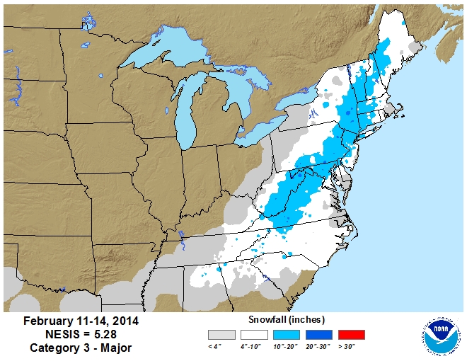
A few others have mentioned already, there are a lot of similarities with Feb 2014 with this setup. Looking very impressive. For reference here's a few links and maps from that storm. Looks like a good analog as it stands now.
WPC Storm Summary
https://www.ncdc.noaa.gov/sotc/snow/201402
... "approximately 700,000 homes lost power, with half of those being in South Carolina and Georgia alone"...


WPC Storm Summary
https://www.ncdc.noaa.gov/sotc/snow/201402
... "approximately 700,000 homes lost power, with half of those being in South Carolina and Georgia alone"...
I think if you live in Morrisville brier creek falls lake you have a shot to stay below freezing as you get into central wake 33-34, east wake and here might be pushing 40Yeah my thoughts exactly. I think we should mostly stay frozen at least. What’s your opinion on it. You think we switch to a driven rain and end with nothing after it washes away our snow ?
BHS1975
Member
We could use about 1 state later on the negative tilt
That's doable at this range
Sent from my iPhone using Tapatalk
As for the 2014 analog...this potential event does a stout 50/50 which I thought gave it a better chance to stay suppressed. but none the less....any winter event just wants to deepen and rip n/w
The question isn't whether there is a storm is who in the south is going to get 6-10"....
 but none the less....any winter event just wants to deepend and rip n/w
The question isn't whether there is a storm is who in the south is going to get 6-10"....
but none the less....any winter event just wants to deepend and rip n/wbigstick10
Member
From KATL, WOW
While we cannot rule out some isolated light rain or snow showers
in parts of the far north late Thursday with a weak disturbance
and some possible moisture skirting the area, the main focus is
for the weekend system of what has the potential to be a
significant winter event late Saturday through Sunday. What is
worrisome for now is how the latest Euro has trended to a
stronger system and how both the GFS and Euro have a possible
strong classical CAD wedge setting up ahead of a robust upper
cutoff trough and translated sfc low that could under go Miller
Type A cyclogenesis. There are some differences in the southern
extend of the piece of energy and where the sfc low gets better
organized (where along southern baroclinic zone of the wedge or a
bit farther north). Regardless, the strength of the parent high
and wedge could play a large role in what mixed p-type could
result and if freezing rain will be an impact ahead of what may
transition into significant snow from the upper wave dynamics. All
this being said and the aforementioned wave is currently way off
near Hawaii so obviously much can change and the run-to-run
consistency will be a big factor in gaining more confidence.
Hesitate to talk about snow/ice totals at this point because so
much could change given spread of amounts or location with the
various models, though just want to say that significant amounts
of either or both are possible and should get better ideas in the
next few days. Stay tuned and the previous discussion follows...
Something interesting about that 2014 storm is that the low basically tracked right up I-95 yet there was still a good period of heavy snow on the front end before heavy sleet and some ZR on the NC Piedmont, then the foothills and western Piedmont got absolutely plastered by the deform band on the backsideAs for the 2014 analog...this potential event does a stout 50/50 which I thought gave it a better chance to stay suppressed.
The question isn't whether there is a storm is who in the south is going to get 6-10"....
View attachment 103953 but none the less....any winter event just wants to deepend and rip n/w
iGRXY
Member
ICON is up. Let's see if it follows suit with the rest of the guidance.
smast16
Member
It's a question of where that R/S/ZR line is. I want nothing to do with that mess on this one.As for the 2014 analog...this potential event does a stout 50/50 which I thought gave it a better chance to stay suppressed. but none the less....any winter event just wants to deepen and rip n/w
The question isn't whether there is a storm is who in the south is going to get 6-10"....
View attachment 103953 but none the less....any winter event just wants to deepend and rip n/w
D
Deleted member 609
Guest
If I am remembering correctly the people in Raleigh were expecting pretty much rain only on that one but ended up getting some snow/sleet.Something interesting about that 2014 storm is that the low basically tracked right up I-95 yet there was still a good period of heavy snow on the front end before heavy sleet and some ZR on the NC Piedmont, then the foothills and western Piedmont got absolutely plastered by the deform band on the backside
BHS1975
Member
Something interesting about that 2014 storm is that the low basically tracked right up I-95 yet there was still a good period of heavy snow on the front end before heavy sleet and some ZR on the NC Piedmont, then the foothills and western Piedmont got absolutely plastered by the deform band on the backside
Meh need that low to stay offshore.
Sent from my iPhone using Tapatalk
Regardless of trends this will most likely be the first significant and widespread winter storm That the SE has seen in quite a while
I've lived on the line for many a storm these past few years. I've done good but it sucks to sweat out the transition line being so close. The Wake County cut off seems to be a real thing; but as I've said earlier, I'm banking the CAD is stronger and the low ends of being father east.I think if you live in Morrisville brier creek falls lake you have a shot to stay below freezing as you get into central wake 33-34, east wake and here might be pushing 40
From RAH:
The overwhelming majority of the forecast interest is obviously on
the Saturday night - Monday time period, and for good reason.
Previous model solutions were somewhat unclear with the
GFS/GEFS/ECENS all indicating the potential for wintry precipitation
for our area, while the deterministic ECMWF was the outlier in
showing a system to our south with little in the way of impactful
weather across NC. Today`s ensemble data and 12Z deterministic
guidance has come into better agreement, albeit with a curve ball in
the form of a pronounced warm nose across Coastal Plain and central
Piedmont. While all the models indicate the potential for precip
Saturday night through Sunday night as an initial low dives through
the Midwest into the Deep South, the guidance is also showing a
secondary coastal low developing Sunday morning (Miller-B style)
with a pronounced warm nose from 925-850mb extending well inland
Sunday afternoon. For being vastly different 12 hours ago, both the
EC and GFS deterministic show 40-50kt easterly 925-850mb winds with
temperatures forecast to rise to around +1C in the western Piedmont
and up to around +6C across the Coastal Plain. Cold air would
eventually wrap back around the system as it exits to the northeast
early Monday morning, perhaps chasing the moisture out of the area
in the process.
At this stage of game, despite an apparent convergence of solutions
with today`s 12Z deterministic guidance and suggestions of support
from their ensembles, there is still a lot of uncertainty that needs
to be sorted out. Precip chances continue to increase during this
period, but the potential for a substantial warm nose could result
in some areas that see snow, ice, rain, or a mix of all the above
with this event. Much will ultimately depend on how closely the low
stays to the coast and the strength/position of the surface ridge to
our north. We`ll continue with the mention of rain/snow for Sunday
into Monday but still too early to talk amounts or icing potential
with any degree of certainty.
Mmfs has a 3km grid distance.What's the best short range model to pick that up the earliest usually?
bigstick10
Member
KATL:
While we cannot rule out some isolated light rain or snow showers
in parts of the far north late Thursday with a weak disturbance
and some possible moisture skirting the area, the main focus is
for the weekend system of what has the potential to be a
significant winter event late Saturday through Sunday. What is
worrisome for now is how the latest Euro has trended to a
stronger system and how both the GFS and Euro have a possible
strong classical CAD wedge setting up ahead of a robust upper
cutoff trough and translated sfc low that could under go Miller
Type A cyclogenesis. There are some differences in the southern
extend of the piece of energy and where the sfc low gets better
organized (where along southern baroclinic zone of the wedge or a
bit farther north). Regardless, the strength of the parent high
and wedge could play a large role in what mixed p-type could
result and if freezing rain will be an impact ahead of what may
transition into significant snow from the upper wave dynamics. All
this being said and the aforementioned wave is currently way off
near Hawaii so obviously much can change and the run-to-run
consistency will be a big factor in gaining more confidence.
Hesitate to talk about snow/ice totals at this point because so
much could change given spread of amounts or location with the
various models, though just want to say that significant amounts
of either or both are possible and should get better ideas in the
next few days. Stay tuned and the previous discussion follows...
Look like big changes on the 18z Icon.
ICON is coming in much flatter thru hr 90. It is interacting a lot more with the SW cutoff
Icon being off it's rocker is a point of validation for most around hereICON is coming in much flatter thru hr 90. It is interacting a lot more with the SW cutoff