SimeonNC
Member
39.6/26.1
31/16 but I suspect that DP is too high, everywhere else up this way single digits37/20 wind NE 4
Ok… so what effects does this typically produce in a storm? Stronger, weaker, more or less moisture? Still can’t figure out how this thing Is cutting up through the wedge.The system is occluding(trying to stack the surface low vertically on the bottom of the upper level low)....that's how you get a double barrel low.
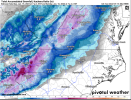
 Latest HRRR keeping upstate thru Charlotte snow on the fronto band still. Getting excited now.
Yea it also has 8 inches in southern upstate. Hard to believe it.Dang it HRRR up to almost 2" here, not gonna happen and I'm not falling for it nope nope nope
Which model do you prefer?Snowline is literally right on my house at this time with 45+ dbz returns. Please please plase be cold enough for some flakes.

If anything 0z looks south than 18zLast two HRRR runs are not good for north ms. Looks like it’s started it’s northward trend
Chris Justice is leaning very heavy on a warm nose taking over fairly quickly. I haven't seen anything today pointing toward that. In fact as you said everything leaning to more Snow for longer period.HRRR is keeping the northern half of Greenville, Spartanburg, and the NW sections of Cherokee county snow for roughly 8 hours in that initial wave.
Main band of snow has definitely moved south the last few runs in ALIf anything 0z looks south than 18z
The rain snow line has definitely went north in the last two runs. Precip is much lower also. The low is probably pivoting at that time alsoIf anything 0z looks south than 18z
Wait until you see the latest accumulated snowfall for Cumming.0z HRRR a tick south through hour 13

It’s amazing this can’t whip around and give CAE some love.hrrr just pivots around and buries the huntsville area View attachment 106290
hrrr just pivots around and buries the huntsville area View attachment 106290
You can toss the globals….hi res models are all that matter.Let’s see if the 00z nam catches on
Sent from my iPhone using Tapatalk
Increased totals here in VA aswellView attachment 106283
View attachment 106284
View attachment 106285
That's a lot for a snow depth after switching to sleet for a few hours.
You can toss the globals….hi res models are all that matter.
Nam is a hi-res model?You can toss the globals….hi res models are all that matter.