• Hello, please take a minute to check out our awesome content, contributed by the wonderful members of our community. We hope you'll add your own thoughts and opinions by making a free account!

Pattern Jammin' January

All I need is a western ridge and a -epo . You Carolina peeps can worry about the NAO . I figure we get a 2-3week window with chances starting the week of the 20th. A -epo pattern has been money for the last decade for my area . What’s the saying , if it’s not broken don’t fix it .


That said if we happen to get a -NAO that’s great . Then maybe we can get a slow crawling Miller A . One can dream right ?


Sent from my iPhone using Tapatalk

Agreed. I think your -EPO pattern is a given honestly. I've said from day one that's probably going to be this winter's theme....persistence. What we've had in our cold patterns this year is what we've had for the last several winters, -EPO/+PNA/+ or neutral NAO.

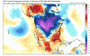
The weeklies at week 4 have a true -NAO with not just ridging over greenland, but lower heights in SE Canada/Nova Scotia/West Atlantic. That's what I'd really like to get a hold of, but what I think is a mirage. The west coast ridging just does not want to leave. I think when we get rid of the WAR and get a true -NAO we get a real Miller A IMO.

1547216346246.png
 
Man St. Louis gets crushed again next weekend with snow on the 12z gfs


Sent from my iPhone using Tapatalk
All of their snow probably won't even be melted by then lol.
Could you imagine with the artic gates opens up with all that snow on the ground. It wouldn’t be much moderation in temps. That would pretty awesome..
 
yep... were going to have to get a neg nao in some fashion to drive the storm track south....

We don’t need that , we just a western ridge to establish. There is plenty of cold air around

But since you mentioned the nao the 12z gfs goes nuts
77b95af6f648ef8088b75130c9f82cb4.jpg


Sent from my iPhone using Tapatalk
 
We don’t need that , we just a western ridge to establish. There is plenty of cold air around

But since you mentioned the nao the 12z gfs goes nuts
77b95af6f648ef8088b75130c9f82cb4.jpg


Sent from my iPhone using Tapatalk
Just beautiful!!! This is what we have been waiting. And the best thing is... It’s within our grasp...
 
OhV and interior NE look great for snow blitz next couple of weeks. As mentioned cold coming to NA.

View attachment 10688

For the SE we look to remain wet.

View attachment 10689
Yep and realistically we knew this had to happen first, truly the beginning of that step down process.... just think of the snowpack to our N/NW, systems like this weekends want be marginal then. Welcome winter, better late than never
 
Yep and realistically we knew this had to happen first, truly the beginning of that step down process.... just think of the snowpack to our N/NW, systems like this weekends want be marginal then. Welcome winter, better late than never
If we don't get a quick reversion back to a crappy pattern, that snowfall should remain up there for a while. That could definitely help us down the road. Still would really like to see some semblance of true blocking down the line.
 
yep... were going to have to get a neg nao in some fashion to drive the storm track south....

The NAO is key for our wonderful dear MA and NE friends. We like it but this time of the year, gimme a negative EPO and a trough directly down the Mississippi to the gulf and hand me my damn sled.


Sent from my iPhone using Tapatalk
 
OhV and interior NE look great for snow blitz next couple of weeks. As mentioned cold coming to NA.

View attachment 10688

For the SE we look to remain wet.

View attachment 10689

It's semantics probably but to me we're not in a true pattern change to colder than normal yet. Next week and a half we bounce to cool/warm back and forth. MLK is really the date GEFS locks in on as the true pattern change to colder than normal over the SE. You can see Canada literally open up and the cold flows in. Looks great. Not sure we want the PV in the center of Canada, need more blocking over the top to get it SE Canada.
 

Attachments

  • gfs-ens_T2ma_namer_fh192-282.gif
    gfs-ens_T2ma_namer_fh192-282.gif
    1.8 MB · Views: 24
It's semantics probably but to me we're not in a true pattern change to colder than normal yet. Next week and a half we bounce to cool/warm back and forth. MLK is really the date GEFS locks in on as the true pattern change to colder than normal over the SE. You can see Canada literally open up and the cold flows in. Looks great. Not sure we want the PV in the center of Canada, need more blocking over the top to get it SE Canada.

EPS isn’t as enthused with the deep cold. As you mentioned the PV west of Greenland isn’t good.

3C4DEEE0-2102-4301-8631-25FF02977238.png8D9E0D6E-6BD5-46D7-8D97-46B4E1726D23.png
 
Dropping this bad boy off from the FV3 in fantasy land:

View attachment 10693

Looks like a good one, doesn't it? IF this ends up coming true, I'll end up chasing it (probably just going to Lafayette).


Might not be a fantasy after all. The models are all over the 20th to the end of the month with storm chances. I think it's either going to be just bad luck or the models are completely off with the pattern coming up for there not be at least one good storm between the 20th and 31st.
 
EPS isn’t as enthused with the deep cold. As you mentioned the PV west of Greenland isn’t good.

View attachment 10695View attachment 10696

For areas to the west we will gladly take that PV placement . I love the trough orientation for MBY that you posted above . It really depends on ones location when looking ahead in the LR and seeing the different looks. Certain looks would benefit some areas of the southeast while screwing others .

As nice as it looks I know it will look different on tonight’s runs. I think we will have a true idea of where we are headed by around the middle of next week say Wednesday


Sent from my iPhone using Tapatalk
 
Back
Top