whatalife
Moderator
Well look that is hope! 

Sent from my iPhone using Tapatalk


Sent from my iPhone using Tapatalk
Icon says we golf next week
Sent from my iPhone using Tapatalk


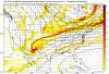
Some gefs support

Sent from my iPhone using Tapatalk
I need that juts slightly further southE13 and we all call it a winter
Sent from my iPhone using Tapatalk
until euro is on board. No need to get excited ...E13 would make everyone here happy.
Sent from my iPhone using Tapatalk
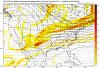
Anallogs, about to be going down with the burning unicorns, in the burning dumpster!FV3: still no cold dominated pattern as of yet (per 12z) but instead cold is more in and out meaning averaging close to normal
If this verified, MBY might see some sleet. Here's hoping!FV3 says yes to a winter storm for the western parts of the southeast this run. Think it's the best it's looked so far and honestly I'm going to be ill with this one if it works out as the way it looks on the model as I don't really want to travel this soon and it has me missing snow in Lafayette by 9 days.
until euro is on board. No need to get excited ...


Finnally a threat for us to track.
 Game on!!!
We need the s/w in the southwest to dig more and miss the northern wave. Would end up a much bigger deal.


Also have a little better cold near by also.
Sent from my iPhone using Tapatalk

Where’s the track of the the low in that storm?Euro is on board with the general idea

Sent from my iPhone using Tapatalk
Precisely the time period I mentioned also. I'm in total agreement (no surprise) haha.I know it’s easy to get lost in all the big dogs that winter but 2009-10 was not wall-to-wall cold we had a pretty formidable thaw in January 2010 that ended with the storm on the 29th & 30th. I still like the idea I alluded to last week where the next significant threat for wintry weather around here shows up when the MJO reaches phase 7, that puts us in the 2nd-3rd week of January (Jan 7-20)
Where’s the track of the the low in that storm?

 ??
??
At least it's not a torch, and we're in the ballpark. Although it feels like we're batting against Verlander at the moment.The moisture seems to be available. The cold is in question
Sent from my iPhone using Tapatalk


It's going to depend on how far south and east the boundary will stall. Of course, the further south and east the boundary is, the colder it will be further south and east.The moisture seems to be available. The cold is in question
Sent from my iPhone using Tapatalk
Chris you think we’re in play down here?Euro is slowly warming up to something potentially next week as well. Looked colder for it too.

maybe you would, not here, lolE13 and we all call it a winter
Sent from my iPhone using Tapatalk
It's not really a storm, it's moisture that is associated with the boundary. I mean, there could be a weak low that's embedded that tracks along the boundary. Sometimes, when there is moisture along the boundary, there can be a main low that develops on the tail end of the boundary.Where’s the track of the the low in that storm?