-
Hello, please take a minute to check out our awesome content, contributed by the wonderful members of our community. We hope you'll add your own thoughts and opinions by making a free account!
You are using an out of date browser. It may not display this or other websites correctly.
You should upgrade or use an alternative browser.
You should upgrade or use an alternative browser.
Larry, of course my knee-jerk reaction is to say the FV3 but it's probably somewhere in between. In that time period, the MJO is supposed to move into COD (phase 8/COD using your graph from the other day) and that would lend itself to be a good indicator for colder so I guess there is that.The 6Z GFS was the warmest yet and downright mild in the SE for early Feb. But ironically, the 6Z FV3 was one of the coldest runs yet for early Feb. Which is more believable?
accu35
Member
12z Nam mid week system. Nothing big but something interesting.

ForsythSnow
Moderator
It's not as impressive as it seems. If you check the soundings, it's very dry in the DGZ. With that said, the narrow band behind the line has been increasing for real wintry precip vs what appears to be. It is good for TN though.12z Nam mid week system. Nothing big but something interesting.

On the other hand, the ZR depicted seems to be more troublesome as it could verify easier.

NWMSGuy
Member
I would say if we still have this mid week chance showing up after the 12z run of the FV3 we should start a thread.
ForsythSnow
Moderator
I'd say tomorrow if things look good feel free to fire one up. Maybe even this evening.I would say if we still have this mid week chance showing up after the 12z run of the FV3 we should start a thread.
NoSnowATL
Member
I'd say tomorrow if things look good feel free to fire one up. Maybe even this evening.
Just don’t read the crazy thread when you do. Just so friendly advice. Those guys are brutal.
Sent from my iPhone using Tapatalk
Blue_Ridge_Escarpment
Member
Folks in the CAD areas need to pay attention to Tuesday night Wednesday morning. Cold temps in place and light moisture moving in.
Snow Showers per 12z GFS keep holding on a little more and more further east into GA for the mid-week system, doesn't seem to be much in the way of accumlation but would be fun to wake up to snow showers in the AM.
ForsythSnow
Moderator

GeorgiaGirl
Member
That storm might actually have legs too, other modeling has been showing something for then. Hopefully we're able to haul in either the weekend one, or the last of the month one.
Stormlover
Member
Oh Canada!CMC really blowing up storm 2.


Stormlover
Member
ForsythSnow
Moderator
If we still have it tomorrow I would gladly start a thread. It's just being noticed more today.need another thread for the end of month time
whatalife
Moderator
CMC really blowing up storm 2.
This would also be a nice ice storm for several south and east of the snow line. Let’s see where this goes in the coming days.
Sent from my iPhone using Tapatalk
RobertRath
Member
I’d take the latest cmc run and call it a winter. Been a long time since I’ve seen a 10” snow in my area.
BillyMurrayWx
Member
The storm on the Canadian next week looks like a true southern slider and is in the time frame that Webber spoke of a few days back. It also follows this weekend storm bombing out in the northeast. I believe this is a better setup than this coming weekend for the southeast as a whole.
LovingGulfLows
Member
- Joined
- Jan 5, 2017
- Messages
- 1,499
- Reaction score
- 4,100
The storm on the Canadian next week looks like a true southern slider and is in the time frame that Webber spoke of a few days back. It also follows this weekend storm bombing out in the northeast. I believe this is a better setup than this coming weekend for the southeast as a whole.
Remember when we said this about this weekends storm and how the January 24th storm would "set up" for it?
BillyMurrayWx
Member
I do. We still haven’t had that yet either but we do have some models now around 5 days out showing this one bombing out so maybe this is the one. I know it would definitely make me feel better going forward about the pattern. The 12z Gefs continues to break down the ridge in the West by the end of month tooRemember when we said this about this weekends storm and how the January 24th storm would "set up" for it?
Last edited:
Stormlover
Member
Euro throws another solution at end of run
To everyone chasing a Nw trend: What the Euro showed at the end of the run actually has that kind of potential. Favorable high pressure. This is our bread and butter..all of this is assuming we hold the general look for the next 4-5 days
What are temperatures during that euro storm ... wondering what ratios would be like ??
I don’t want to lead people on but this late run CMC Euro combo is a pretty good one
Euro throws another solution at end of runView attachment 12354View attachment 12354
The 6”+ showing up on the 12Z Euro 1/30-31 in SW/SC GA cities like Tifton and Albany would likely be alltime snowstorm records as they were south of the heaviest snow of Feb of 1973, when they got about 3”:

Storm5
Member
12 eps is pretty excited about next Tuesday and Wednesday
Sent from my iPhone using Tapatalk
Sent from my iPhone using Tapatalk
NEGaweather
Member
The weeknd storm is just setting the stage for a bigger storm mid next week.
Sent from my SM-G955U using Tapatalk
Sent from my SM-G955U using Tapatalk
Shocker12 eps is pretty excited about next Tuesday and Wednesday
Sent from my iPhone using Tapatalk
Sent from my SM-G950U using Tapatalk
Don’t be shy... let’s SEE IT12 eps is pretty excited about next Tuesday and Wednesday
Sent from my iPhone using Tapatalk
CentralGAColdFront
Member
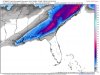
I think that the region is due for another event like this one, they seem to come every 40-60 years. I know that all of the old timers in my area apparently always said that the amount from the 1973 storm was basically double what they got during the previous marquee event for the region (Feb. 1914).The 6”+ showing up on the 12Z Euro 1/30-31 in SW/SC GA cities like Tifton and Albany would likely be alltime snowstorm records as they were south of the heaviest snow of Feb of 1973, when they got about 3”:
View attachment 12360
Snowflowxxl
Member
Its gonna be completely different in 12 hours lol no need to be so excited.Don’t be shy... let’s SEE IT
Don’t be shy... let’s SEE IT
I will post and no need to give up.Its gonna be completely different in 12 hours lol no need to be so excited.
90 percent of this is next week storm. 
As I delve into this a little more, what the CMC and I’m assuming the Euro Is showing this as well, it’s a pattern breakdown hit. Western ridge falls apart with waves beginning to slam into the west coast. This threat holds some value because of this. Just Jimmy’s take
Tacoma
Member
You know we have multiple storm chances showing for the next 7 to 10 days and not one forecast for the next ten days are showing a snow symbol yet or none are talking about the chance of snow yet. 
whatalife
Moderator
As I delve into this a little more, what the CMC and I’m assuming the Euro Is showing this as well, it’s a pattern breakdown hit. Western ridge falls apart with waves beginning to slam into the west coast. This threat holds some value because of this. Just Jimmy’s take
We get some of our best storms as the pattern relaxes.
Sent from my iPhone using Tapatalk
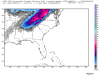
The Euro is showing totals in southern ga and SC but the EPS is showing highest totals in mountains and TN.90 percent of this is next week storm. View attachment 12367
We get some of our best storms as the pattern relaxes.
Sent from my iPhone using Tapatalk
It is no coincidence that the12Z Euro has for the big snow 1/30-31 that includes your area a pretty weak low crossing central FL. You probably already realize this. But in case you don’t, most of the biggest Columbia snows were from fairly weak to weak lows (while still in the Gulf) that later crossed central FL, not N FL.
GeorgiaGirl
Member
The Euro is showing totals in southern ga and SC but the EPS is showing highest totals in mountains and TN.
Meh that's the ensembles for you. And the EPS has a lot of them. Although I haven't really looked into that threat hard, from what I have seen, it has legs as a system and the outcomes being suggested are all over the place.
We can't get a clue on a system that is happening this weekend (as I KNOW that song and dance ain't over based off past history), so just imagine how long it's going to be for that one?
Complete eps run 12z