JLL1973
Member
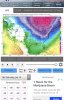
Continuing to decrease in my area10 day gefs mean
View attachment 11928
Continuing to decrease in my area10 day gefs mean
View attachment 11928

Oh yeah, I know it's off but even half of that would be great. All tho, temp profile does seem like it would support the snow.
For most of Tennesse and North Carolina in general I'd say...
Dusting to 1 is meh.
1 to 2 is a small snow
3 to 5 is a medium snow.
6 to 10 or more is a big snow.[/QUOTE

Indeed a nice 1048 high charging down ... with some energy at southern end ... ?Happy hour 18z gfs is gonna be much much colder this run
Sent from my iPhone using Tapatalk


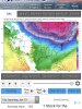
Developing low over northern TX.
Sent from my iPhone using Tapatalk
your standards are way too high

Weak and falls apart. Boring. Next run will be different anyway.
Weak and falls apart. Boring. Next run will be different anyway.
Yeah nothin big, but it did trend little colder with a change over further east as well. Will see what the next few days trend. As others says, cold chasing moisture, but I can see dusting to and inch out of this for someone in the SE.In all seriousness, a slight improvement on the GFS for midweek, nothing to get worked up over though.
The feature isn't what I'm calling boring. The run is. Of course we have time to watch it and see if it improves.Lol that’s boring ??? It’s boring cause it does not show anything over your house . That has huge potential
Sent from my iPhone using Tapatalk
Yes it does. Really good for one's in the midsouthLol that’s boring ??? It’s boring cause it does not show anything over your house . That has huge potential
Sent from my iPhone using Tapatalk
Brick cmon now... if that goes neutral a frame sooner than it’s crush job for N.C.Folks have been saying that for days, but it doesn't matter for NC. None of the runs are really showing wintry weather here next week.
Weak and falls apart. Boring. Next run will be different anyway.
Yeah, it took me two freak Ull's to get that much snow, and that was over two different years, a long time back, and those were spring storms melting as they fell....and they didn't even touch much above Rome.I have avg .25 of snow the last 4 years. 1-3 would be heaven on earth.
Sent from my iPhone using Tapatalk
Weak and falls apart. Boring. Next run will be different anyway.