GeorgiaGirl
Member
Jon,
Thanks. Aren't those just the 0Z EPS maps? (through day 15, which we've already seen. ). I'm looking for weeks 3-6.
I don't pay, but Ryan posted this (not a 500 mb map):
Jon,
Thanks. Aren't those just the 0Z EPS maps? (through day 15, which we've already seen. ). I'm looking for weeks 3-6.

Someone just said it was only for Mississippi, lol. Why do people post bogus model reviews?Lot will change, but this has potential written all over it to me

Have you not seen how fraudulent the FV3 snow maps have been all year. I stand by my statement. Fv3 snow maps on TT are trash, like this pattern.Someone just said it was only for Mississippi, lol. Why do people post bogus model reviews?
In addition, the simulated radar for the FV3 didn't really show any substantial snow for anyone BUT MS. Maybe some snowflakes here and there for other areasHave you not seen how fraudulent the FV3 snow maps have been all year. I stand by my statement. Fv3 snow maps on TT are trash, like this pattern.
No matter what period you choose, the vortex on the Pacific side of the arctic has been progressively intensifying on the Euro ensemble of late contributing to the increasingly positive AO as verification closes in. This is not a trend I want to see continue.
View attachment 11581
View attachment 11580
View attachment 11579
Look at the ENS, they will tell the story. Lot of them support MS/AL as wellIn addition, the simulated radar for the FV3 didn't really show any substantial snow for anyone BUT MS. Maybe some snowflakes here and there for other areas
Jon,
Thanks. Aren't those just the 0Z EPS maps? (through day 15, which we've already seen. ). I'm looking for weeks 3-6.


Linked the wrong maps sorry


WHERE YALL GETTING THE ECMWF EPS ENSEMBLE MEAN MAPS? IM A SUBSCRIBER TO WEATHERMODELS BUT CANT SEEM TO LOCATE THEMThanks, Jon. My maps finally came in and days 16-25 are colder than the prior run, especially up in the Midwest but down here to a lesser extent. Coldest periods (absolute and anomaly) in the SE are days 11-25. Afterward, it still remains a colder than normal to the end though not as cold.
-NAO/-AO dominates but you can see the delay when comparing to the prior run. Each week had a change to lower heights in the Arctic from the prior run.
Precip near normal in SE.
Am I the only person that yells his posts in my head when I read them or no lol.WHERE YALL GETTING THE ECMWF EPS ENSEMBLE MEAN MAPS? IM A SUBSCRIBER TO WEATHERMODELS BUT CANT SEEM TO LOCATE THEM
(no)Am I the only person that yells his posts in my head when I read them or no lol.
SORRY GUYS IM AT WORK AT 9-1-1 AND WE HAVE OUR SYSTEM LOCKED TO WHERE IT IS ONLY CAPS LOCKED ON.Am I the only person that yells his posts in my head when I read them or no lol.
WHERE YALL GETTING THE ECMWF EPS ENSEMBLE MEAN MAPS? IM A SUBSCRIBER TO WEATHERMODELS BUT CANT SEEM TO LOCATE THEM
@psuhoffman I'm forecasting an onslaught of "models suck" in the near future.
SORRY GUYS IM AT WORK AT 9-1-1 AND WE HAVE OUR SYSTEM LOCKED TO WHERE IT IS ONLY CAPS LOCKED ON.
YES THANK YOUThis what you looking for? The weeklies are the EPS 46 Days and the regular EPS is also below.
View attachment 11615
.png")


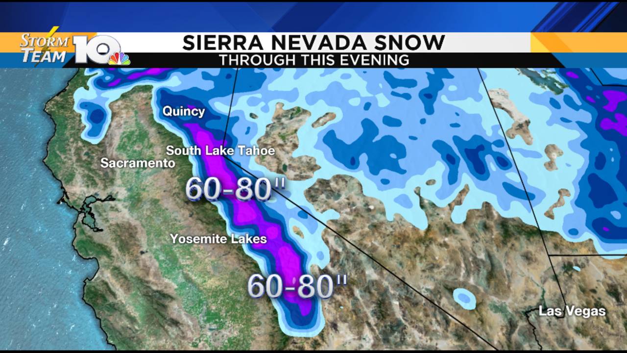
I bet the snow lovers in Reno just hate those mountains! LOL! Went to Tahoe once at the end of June and there were still piles of snow in the mountains and passes. Beautiful country.Posted: 6:59 AM, January 17, 2019Updated: 6:59 AM, January 17, 2019
IF THE PHONE RINGS, PLEASE ANSWER
Sent from my iPhone using Tapatalk
YOU'RE FIRED!IF THE PHONE RINGS, PLEASE ANSWER
Sent from my iPhone using Tapatalk
I bet the snow lovers in Reno just hate those mountains! LOL! Went to Tahoe once at the end of June and there were still piles of snow in the mountains and passes. Beautiful country.
No you're not! I thought I was the only oneAm I the only person that yells his posts in my head when I read them or no lol.

")
Posted: 6:59 AM, January 17, 2019Updated: 6:59 AM, January 17, 2019
No worries. Everything is on track for right now.0z looks like there's less cold press behind next week's system vs 18z. Also the low is further north and the HP behind it is slightly weaker.
Sent from my SM-G950U using Tapatalk


