Storm5
Member
So now we have the gfs and the FV3 popping a low mid week . Let’s see what the ole euro does in a few
Sent from my iPhone using Tapatalk
Sent from my iPhone using Tapatalk
Disclaimers on half the models sometimes it is true not 100% accurate plus have to wait for Freezing rain etc output on Pivotal which takes foreverJust a reminder that the FV3 maps on TT are inaccurate. The coding or something is messed up, so the totals are not accurate.

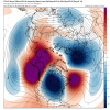
If it does phase, it would phase further north and east, well away from the southeastern US. A strong low off to the north and east would reinforce the cold air though.Delta actually said last night that if the southern part was more neutral tilted (with the 0z FV3) that there is phase potential with it. And maybe I'm hallucinating but this looks like a late phase to me:
View attachment 11538

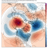
Also, here is the complete run of the 12z GEFS.
View attachment 11545

Seems like it is continuing to decrease for NC. The ensembles were about the only thing giving NC peeps hope for anymore snow before the end of the month. The ops continue to be even less hopeful.
I’d much rather have a solution like the 12z gfs is showing with a weaker northern stream press vs the bone chilling over crushing runs like the last few cycles had
Sent from my iPhone using Tapatalk
the pattern that's showing for the next 7-10 days favors areas west of the mountains. that does NOT mean a system cant work out for your area though in that timeframe .
The cold isn't in place further east due to the boundary. For area's further east to receive frozen precip. is 1) The boundary needs to be in place further south and east. Or, 2) The system needs to separate from the trailing energy to allow a 2nd separate system which would possibly bring a wider coverage of frozen precip.The question to be asked for FV-GFS between hours 144 and 162 hours what other elements are need to beef up this storm the cold being in place by another 12-24 hours for MS/AL/GA would be really nice
What specifically about the modeled 500mb pattern has evolved in such a manner for you to draw this conclusion? Because I think the pattern is ripe from 1/26 onward for anywhere in the southeast to score based on the current ensemble 500mb means.Seems like it is continuing to decrease for NC. The ensembles were about the only thing giving NC peeps hope for anymore snow before the end of the month. The ops continue to be even less hopeful.
Smarter minds can tell me if this is right but the midweek storm seems to be trending further south if this trend continues parts of GA could be in play
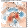
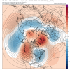
Agree. But can that model be right one time ? PleaseSheash, next week on is weenie central......Amazing look at 500mb on GFS/FV3.
Yes. We are getting close to being in that range with the gfs twins.Agree. But can that model be right one time ? Please
That's right, a much larger portion of GA and the southeast could be at play. The main low cuts, but we're going to have to watch the energy that is tailing the trailing energy. For now, it's a frontal system that would bring some snow for western parts of the southeast, of course things will change.Smarter minds can tell me if this is right but the midweek storm seems to be trending further south if this trend continues parts of GA could be in play
Yes. We are getting close to being in that range with the gfs twins.
Sleeting a little bit now in liberty sc. nice to see at least
Sent from my iPhone using Tapatalk
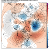
Look at the FV3! Let's get this to day 5 for the Alabama folks! Also think @olhausen might like this too.
View attachment 11554
If the CFS is right, we have atleast five weeks of this place becoming this. Good luck Shawn and mods.
What is the CFS showing?If the CFS is right, we have atleast five weeks of this place becoming this. Good luck Shawn and mods.
What is the CFS showing?
What specifically about the modeled 500mb pattern has evolved in such a manner for you to draw this conclusion? Because I think the pattern is ripe from 1/26 onward for anywhere in the southeast to score based on the current ensemble 500mb means.
It's just noise beyond D10. The pattern still looks very favorable. Even the op run of the GFS and FV3 had loads of potential (again, too far out but they look similar to the ensembles so you can draw some conclusions from that at least).Just looking at the totals for the GEFS mean, and it looks to have decreased for NC.
Yes it have, but i expect for it to go back and forth as even the ensembles are trying to figure out what the hell is going on with all this energy that will be flowing around.Just looking at the totals for the GEFS mean, and it looks to have decreased for NC.
What did the euro show for this weekend
Well what did euro do with the first system for west and middle tn?So who do we believe the euro or the gfs??