Really have to hope (for the 1st threat) that energy can dive SSE thru CA and into northern Baja area and then heads east. You don’t want it to get hooked by the northern branch. Also we really need more energy to move on shore in the west to track across while the blocks there. D8-14
-
Hello, please take a minute to check out our awesome content, contributed by the wonderful members of our community. We hope you'll add your own thoughts and opinions by making a free account!
You are using an out of date browser. It may not display this or other websites correctly.
You should upgrade or use an alternative browser.
You should upgrade or use an alternative browser.
Pattern Jammin January 2024
- Thread starter SD
- Start date
olhausen
Member
She’s a beaut Clark!This is just the 48 hours around the period in question View attachment 140601
- Joined
- Jan 23, 2021
- Messages
- 4,603
- Reaction score
- 15,199
- Location
- Lebanon Township, Durham County NC
EPS mean looks nothing like the op ?
.gif")

UNCSC
Member
Have we had any storms in our past make a southeastern trend? Seems like every storm pulls northwest the closer wet get to storm the past few yearsReally have to hope (for the 1st threat) that energy can dive SSE thru CA and into northern Baja area and then heads east. You don’t want it to get hooked by the northern branch. Also we really need more energy to move on shore in the west to track across while the blocks there. D8-14
John1122
Member
SE has been a trend so far all fall and winter. It's why places like West and Middle Tn have been in a drought and the midwest hasn't had snow cover.Have we had any storms in our past make a southeastern trend? Seems like every storm pulls northwest the closer wet get to storm the past few years
- Joined
- Jan 23, 2021
- Messages
- 4,603
- Reaction score
- 15,199
- Location
- Lebanon Township, Durham County NC

Cary_Snow95
Member
Is it safe to assume the boundary level is on fire

NBAcentel
Member
EPS has way more stream connection on members which we don’t want
accu35
Member
I didn’t see this time frame map on pivotal @12z Euro.Yeesh lolView attachment 140599
NBAcentel
Member
If we get something big it’s that pac trough pacific shortwave handoff and dipping of the northern stream. That look has been associated with some huge setups in the past 

LukeBarrette
im north of 90% of people on here so yeah
Meteorology Student
Member
2024 Supporter
2017-2023 Supporter
Essentially would want energy to slip underneath the western Ridge?If we get something big it’s that pac trough pacific shortwave handoff and dipping of the northern stream. That look has been associated with some huge setups in the past View attachment 140621View attachment 140622
NBAcentel
Member
Yessss. DefinitelyEssentially would want energy to slip underneath the western Ridge?
hey @Webberweather53 isn't that period jan 19-21 the slot you're keying in onIf we get something big it’s that pac trough pacific shortwave handoff and dipping of the northern stream. That look has been associated with some huge setups in the past View attachment 140621View attachment 140622
NBAcentel
Member
MichaelJ
Member
This doesn't look to me like a NC/SC/Ga storm except ,maybe a little ice, Ms,Tn/Al look to do okay with Tn being the big winner. That has been the normal for several years. Still time for the deprived areas but it will take a lot of changes to score east of the Smokies
Cary_Snow95
Member
I’d expect a bit of a step down pattern but I agree that first one is likely not our stormThis doesn't look to me like a NC/SC/Ga storm except ,maybe a little ice, Ms,Tn/Al look to do okay with Tn being the big winner. That has been the normal for several years. Still time for the deprived areas but it will take a lot of changes to score east of the Smokies
Ron Burgundy
Member
*Edit - Didn’t see the thread for this system. Please move - thanks!*
FFC already chirping about severe with the Friday system. Sheesh, what a start to 2024…
A potent negatively tilted shortwave will dig in from
the central Plains Friday with a surface low developing near the
ArkLaTex. This system appears to have a more favorable thermodynamic
profile with warm surface and dewpoint temperatures and MUCAPE
between 600-800 J/kg. The kinematics of the system also look
favorable for strong to severe storms with bulk shear up to 70+kt
and 0-3km SRH over 700+m2/s2. It`s a little too soon to be diving
into the exact details, but it does appear there is a strong signal
that this system will bring another round of severe weather to the
forecast area Friday afternoon.
Last edited:

We've made some good progress. The trough is dropping east of Seattle. The TPV is slowly trekking west to east across S Canada and underneatth a Greenland block that is trending stronger....and the TPV is pinwheeling there in SE Canada and not racing away.If we get something big it’s that pac trough pacific shortwave handoff and dipping of the northern stream. That look has been associated with some huge setups in the past View attachment 140621View attachment 140622
The last piece I would like to see is for the block and TPV combo to start having more influence on the height pattern behind it, to where flow coming into that combo starts to slow down and back up a bit....sending the full height pattern south a bit and slowing it down

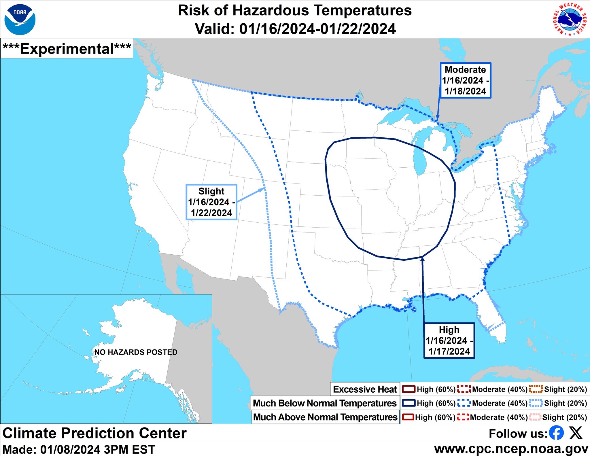
3 run temperature trend on EPS for the 5-day period of Jan 16-21

NBAcentel
Member
Less stream separation so far
accu35
Member
 Here it comes
NBAcentel
Member
This looks complexity different the northern stream calling the shots this run, might turn out to be flatter then previous runs, and more frontal
A 1051 high pressure dropping into Montana at hour 156
accu35
Member

accu35
Member
Much better runnot going to be as good of a run for midsouth area
heckuva front for western SE

accu35
Member

When is the last time NW Georgia had ZR in this setup? Never?

The cold is pushing
accu35
Member

Big difference from the gulf coast to northern bama temps
- Joined
- Jan 5, 2017
- Messages
- 3,796
- Reaction score
- 6,038
My location goes from 60 degrees Monday around 4pm to 29 and freezing rain at 1 am! I call BS as I've never seen an arctic front do that before in my area. They always get hung up on the west side of the foothills.
accu35
Member

Much better
W
WSW
Guest
I remember a cold front dropping the temp from 65 to 32 at home in 2 hours. Only time i have ever experienced that.My location goes from 60 degrees Monday around 4pm to 29 and freezing rain at 1 am! I call BS as I've never seen an arctic front do that before in my area. They always get hung up on the west side of the foothills.