-
Hello, please take a minute to check out our awesome content, contributed by the wonderful members of our community. We hope you'll add your own thoughts and opinions by making a free account!
You are using an out of date browser. It may not display this or other websites correctly.
You should upgrade or use an alternative browser.
You should upgrade or use an alternative browser.
Pattern Jammin January 2024
- Thread starter SD
- Start date


But the average snowfall continues to fall. It's even harder to get snow now.Some people call that winter in the SE.
LukeBarrette
im north of 90% of people on here so yeah
Meteorology Student
Member
2024 Supporter
2017-2023 Supporter

Only two super amped solutions I see right now. Good look right now
He deserves it for sure. #raincold_mettagGive this guy his Met tag already
What went wrong to make them go the wrong direction? Colds still coming.
That may have been the most bleak run I've watched in a while. Ensembles look a little better. But, I don't have any high hopes rn.
LukeBarrette
im north of 90% of people on here so yeah
Meteorology Student
Member
2024 Supporter
2017-2023 Supporter
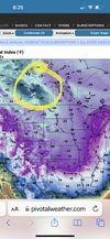
Never mind I see more, still a long way to goView attachment 140428
Only two super amped solutions I see right now. Good look right now
NBAcentel
Member
gefs looks really solid. Especially for the western SE. Don’t get the negativity
- Joined
- Jan 23, 2021
- Messages
- 4,603
- Reaction score
- 15,199
- Location
- Lebanon Township, Durham County NC
A little bit?That may have been the most bleak run I've watched in a while. Ensembles look a little better. But, I don't have any high hopes rn.
NBAcentel
Member
Looks much better especially for the western SE. that’s a mean looking like that. What’s with the crying ? That’s the best look back there in a while 


NBAcentel
Member

Southern Track
Member
Pretty strong members showing up.
Webberweather53
Meteorologist
Plenty of time to fix this setup, but even if I was in the Carolinas or GA, can’t hate seeing the 850 line on the I-20 corridor

Those big HPs coming down from the plains spin clockwise and Cad on the western slopes just like they do us when they are up in yankee land.I wouldn't be surprised to see some snow in TN and Northern parts of Ms, AL, GA behind the big system this week. Those areas tend to do well in the CAA of these amped cutters the last few years
Pattern looks extremely favorable for a lot of wintry potential in the SE. After the 2 big Midwest storms coming up.. look out! That cold will spill down and then the potential for a decent overrunning event is there.
A pretty classic look overall.
I would be excited if I still lived in the SE")
Although I’ll be getting my own action here in southern Illinois!
Cheers.
A pretty classic look overall.
I would be excited if I still lived in the SE
Although I’ll be getting my own action here in southern Illinois!
Cheers.
Because don’t you know that the fun part of this hobby is to live and die with every model run 10+ days out… lol. Anyway, I agree with you, that’s a very good GEFS run and I very much think a winter storm is on the table in the 16-21st timeframe… especially for the western SE and the CAD regions in the Carolinas and NE Georgiagefs looks really solid. Especially for the western SE. Don’t get the negativity
The GEFS snow mean (and highest members) was down significantly from 06z to 12z, I'm really interested to see what 18z holds
NBAcentel
Member
Such a bad look. TPV sagging it’s giant man cojones over us is no bueno, right ? 
Suppressed!Such a bad look. TPV sagging it’s giant man cojones over us is no bueno, right ? View attachment 140439
NBAcentel
Member
Doesn’t get cold like it used to though rightSuppressed!
I had 14 direct hits and 3 close shots that missed mby cause of energy transfers. Thats pretty darn good for 9 days out. Thanks for sharing
NBAcentel
Member
looks warm. I’m no met though 
Yeah that was the best ensemble run I've seen with respect to pressing the storm track / height field to the SE...need more of that though


Snow means never come early in the SE .. almost every time..
Key is finding the cold air and the pattern that can support the winter weather. Then as you get closer is when you see things really start to perk up. That’s just how it goes. No need to panic lol..
Also this is before February .. and February I believe an even better pattern could be on the horizon.
Webberweather53
Meteorologist
Snow means never come early in the SE .. almost every time..
Key is finding the cold air and the pattern that can support the winter weather. Then as you get closer is when you see things really start to perk up. That’s just how it goes. No need to panic lol..
Also this is before February .. and February I believe an even better pattern could be on the horizon.
This is especially true when it comes to overrunning events, like what we may see around mid-month.

Best GEFS mean for BHM all year and it’s in the 8-9 day range.
ghost1
Member

You know looking at some of the event maps on your site, I can remember that a number of those southern slider/overrunning events occurred when there was no mention of snow by local mets until 1-2 days prior to the storm. 12/22-23/1993 is one example of that and more recently the 2/12-13/2010 storm was forecast to be nothing but a chance of flurries until 12 hours before the event started.This is especially true when it comes to overrunning events, like what we may see around mid-month.
- Joined
- Jan 23, 2021
- Messages
- 4,603
- Reaction score
- 15,199
- Location
- Lebanon Township, Durham County NC
16/30 members showing at least something for TDF. Best of the year. Also the coldest run of the year.
NBAcentel
Member
we have ourselves a solid pattern coming up. But the weeklies just ran and I had to post this 
tennessee storm
Member
Wowwe have ourselves a solid pattern coming up. But the weeklies just ran and I had to post this View attachment 140447
- Joined
- Jan 23, 2021
- Messages
- 4,603
- Reaction score
- 15,199
- Location
- Lebanon Township, Durham County NC
 Pulled one for the back yard
Also pulled one for the in laws back yard
Webberweather53
Meteorologist
we have ourselves a solid pattern coming up. But the weeklies just ran and I had to post this View attachment 140447
Brief reshuffling around Jan 23-24 ish then we see the classic February Nino pattern appear w/ +PNA and a -NAO. Bulk of the warm-up in that time probably centered over New England
Drizzle Snizzle
Member
Do you think the first half of Feb will be colder than the second half ?Brief reshuffling around Jan 23-24 ish then we see the classic February Nino pattern appear w/ +PNA and a -NAO. Bulk of the warm-up in that time probably centered over New England
I think the February 12-13, 2010 storm was the same storm that model guidance kept suppressing the slp down to Cuba until about 48-72 hrs prior. I remember that was my early days of participating on weather forums. I think I was following/tracking that event on the Accuweather or Eastern/AmWx forums back then. Memory is kinda fuzzy outside of the meltdowns that happened over those suppressed model runs. ??You know looking at some of the event maps on your site, I can remember that a number of those southern slider/overrunning events occurred when there was no mention of snow by local mets until 1-2 days prior to the storm. 12/22-23/1993 is one example of that and more recently the 2/12-13/2010 storm was forecast to be nothing but a chance of flurries until 12 hours before the event started.
I remember that early in the week, the models were keeping most of the moisture along the I-10 corridor and south. Even still both JB and Frank Strait at Accu-weather were adamant in their blogs blogs and videos that it would end up being an I-40 to I-20 Storm which they ended up being right.I think the February 12-13, 2010 storm was the same storm that model guidance kept suppressing the slp down to Cuba until about 48-72 hrs prior. I remember that was my early days of participating on weather forums. I think I was following/tracking that event on the Accuweather or Eastern/AmWx forums back then. Memory is kinda fuzzy outside of the meltdowns that happened over those suppressed model runs. ??
NBAcentel
Member
18z EPS looks better for our pattern change, now under D7
BHS1975
Member
Plenty of time to fix this setup, but even if I was in the Carolinas or GA, can’t hate seeing the 850 line on the I-20 corridor
View attachment 140436
Yeah give me the powder baby.
Sent from my iPhone using Tapatalk