Webberweather53
Meteorologist
Pretty soon snowpak enthusiasts are going to have to find another excuse as to why we can’t get snow here. Your days are numbered View attachment 140381
@NickyBGuarantee took our snow with him to Illinois
Pretty soon snowpak enthusiasts are going to have to find another excuse as to why we can’t get snow here. Your days are numbered View attachment 140381
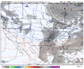
Are you seeing anything that gives you pause for concern? Or do you think everything is progressing nicely for at least a shot of something wintery? Also are your thoughts still the same on a big Feb?The GEFS once again looks pretty good here pattern wise.
Big vortex over SE Canada and the Great Lakes with a trailer disturbance digging into the southern Rockies/ New Mexico.
That’s usually how you get overrunning events in the southern US
View attachment 140384
Are you seeing anything that gives you pause for concern? Or do you think everything is progressing nicely for at least a shot of something wintery? Also are your thoughts still the same on a big Feb?
The GEFS once again looks pretty good here pattern wise.
Big vortex over SE Canada and the Great Lakes with a trailer disturbance digging into the southern Rockies/ New Mexico.
That’s usually how you get overrunning events in the southern US
View attachment 140384
Also looks plenty cold enough with -5C 850s down to I-40
View attachment 140385


Living in the SouthAre you seeing anything that gives you pause for concern? Or do you think everything is progressing nicely for at least a shot of something wintery? Also are your thoughts still the same on a big Feb?

The old hockey stick lookI like!

This has been my concern too. Sure, we’ll get the cold. But, suddenly the moisture pipeline will shut off or we’ll force it too far south to get anything out of it.Been through this too many times. Cold will overwhelm the moisture, after this coming week or weeks of rain, it will probably get to cold to snow. High suppressing moisture to the south. Only shot until Feb, will be when the cold air is leaving we get a return flow of moisture but it has to be quick and timing has to be 100% perfect, other wise you get snow to ice to rain in a matter of hours.
That's the way it is with our climate now. The cold comes with dry air, and the precip comes with warm air.Been through this too many times. Cold will overwhelm the moisture, after this coming week or weeks of rain, it will probably get to cold to snow. High suppressing moisture to the south. Only shot until Feb, will be when the cold air is leaving we get a return flow of moisture but it has to be quick and timing has to be 100% perfect, other wise you get snow to ice to rain in a matter of hours.
Suppression is the last thing we should be worried about right now.This has been my concern too. Sure, we’ll get the cold. But, suddenly the moisture pipeline will shut off or we’ll force it too far south to get anything out of it.
In Atlanta metro, we had the cold air in place, followed by the moisture when we got a good ice/snow storm. I will put my money in that scenario any day over too cold to snow.That's the way it is with our climate now. The cold comes with dry air, and the precip comes with warm air.
Some people call that winter in the SE.That's the way it is with our climate now. The cold comes with dry air, and the precip comes with warm air.
Dude, that's how it's always been! Cold air holds less moisture than warmer air. It's basic physics.That's the way it is with our climate now. The cold comes with dry air, and the precip comes with warm air.
There’s going to be plenty of moistureBeen through this too many times. Cold will overwhelm the moisture, after this coming week or weeks of rain, it will probably get to cold to snow. High suppressing moisture to the south. Only shot until Feb, will be when the cold air is leaving we get a return flow of moisture but it has to be quick and timing has to be 100% perfect, other wise you get snow to ice to rain in a matter of hours.
And the next day...But two days later you end up with this:View attachment 140393
Which you probably won't like as much.

Tornadoes in eastern NC and a run-of-the-mill cold front through AL/GA? Then the trough swings through and it will be back to the SE ridge. It's not going to change.And the next day...

If the Euro is right, which i think we all know by now it isn't, the low will pivot northeast with a glancing blow for the majority of the SE. Ideally, a trailing wave will be there and the low in the NE will be slow to lift out due to the block, giving the trailing wave an opportunity to remain south of the area.And the next day...

Been through this too many times. Cold will overwhelm the moisture, after this coming week or weeks of rain, it will probably get to cold to snow. High suppressing moisture to the south. Only shot until Feb, will be when the cold air is leaving we get a return flow of moisture but it has to be quick and timing has to be 100% perfect, other wise you get snow to ice to rain in a matter of hours.
Is it time to bring out the “Euro is holding back the energy to the southwest” card? I know I’m a weenie but when you cycle through the run it looks like that low in the Rockies doesn’t move for like 3 days.But two days later you end up with this:View attachment 140393
Which you probably won't like as much.
I’m drawing my “euro has amp bias” card.Is it time to bring out the “Euro is holding back the energy to the southwest” card? I know I’m a weenie but when you cycle through the run it looks like that low in the Rockies doesn’t move for like 3 days.
No not really. If anything there's more alignment towards a slower progression and the op gfs is a fast outlierHas really that much changed since yesterday? The highs and lows in here are funny. Ensembles look generally the same
What I learned from Webber's post about what snows in our area is the MJO isn't irrelevant but it's also not the Holy Grail.I'll have to go back and find it. I did glance at it and saw phase 1 was about the worst phase possible for a winter storm. I found that strange since you always here phase 8 and 1 are good.
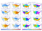
12 and 16 look great!Next week just may get a little interesting around North MS. ?
View attachment 140397View attachment 140398
Then you would love the 00Z version:Is it time to bring out the “Euro is holding back the energy to the southwest” card? I know I’m a weenie but when you cycle through the run it looks like that low in the Rockies doesn’t move for like 3 days.

Really you have to go to the 2nd level with mjo and go mjo plus enso state to get a better idea just saying phase x is result y isn't always applicableWhat I learned from Webber's post about what snows in our area is the MJO isn't irrelevant but it's also not the Holy Grail.
It can literally snow in any of those phases of timing is right.
It may not be the holy grail (I don't think anything is, tbh), but I don't recall very much in the way of cold weather and snowy patterns for the SE when it has been in P3-6, where it has lived the majority of the time in winters of late. I have seen several modeled cold and snowy patterns, but I don't recall observing any actual ones. I will be fair and say that I'm just going from memory and haven't kept a log or anything.What I learned from Webber's post about what snows in our area is the MJO isn't irrelevant but it's also not the Holy Grail.
It can literally snow in any of those phases of timing is right.
Pretty much that's correct. The chances are less in those phases though. The composites here likely focus on the overall pattern in general. Not that we can't time something and snow but I'm not sure any great pattern flip is coming a little after mid month. We are almost certain headed to phase 4 around the 15th which is the worst possible timing for that. It's not a torch pattern moving forward but the cutter pattern probably isn't going anywhere. Now when you get to Feb these stats do change and the MJO holds less influence.What I learned from Webber's post about what snows in our area is the MJO isn't irrelevant but it's also not the Holy Grail.
It can literally snow in any of those phases of timing is right.

Next week just may get a little interesting around North MS. ?
I’d feel really good if I lived I40 northwardNext week just may get a little interesting around North MS. ?
View attachment 140397View attachment 140398
