- Joined
- Jan 23, 2021
- Messages
- 4,603
- Reaction score
- 15,199
- Location
- Lebanon Township, Durham County NC
No one noticed at 18z that KFTY had -tssn on the extracted data on hour 81
Has the 0z NAM started rolling yet?(Am en route to a party rn so can't check)


CAA cut the shield off. We’ll see where it goes
Yeah this a case where you want the WAA to be strong enough to provide the forcing. Even still the soundings across the Upstate and over to CLT metro are still very close.CAA cut the shield off. We’ll see where it goes
What is that?No one noticed at 18z that KFTY had -tssn on the extracted data on hour 81
Yeah that was literally just a case of CAA winning out and eating up the precip shield. Can’t get dynamic cooling without the moisture or WAA driving it.Yeah this a case where you want the WAA to be strong enough to provide the forcing. Even still the soundings across the Upstate and over to CLT metro are still very close.
Thundersnow.What is that?
Guranteed not to snow the rest of the year. Hows thatNo 0z news yet???
 MO
MOIcon sucksNo 0z news yet???


frosty done sold generator
The HRRR and Burell both nailed that one. He was on top of that one for several days and brought it home!If the set up actually occurs, something like the February 2021 event would be on the table. January 2022 had an entrenched dry and cold airmass in place with temps in the low to mid 30s and dewpoints in the lower teens. This would be a very marginal set up where it would be relying 100% on dynamic cooling to crash the column.
What the??? Talk about a screw job ?1/3 is my birthday. This would be pretty special! View attachment 139607
The HRRR and Burell both nailed that one. He was on top of that one for several days and brought it home!
wow is that 15" of snow in Central Mississippi near Jackson ?Also, should add Ukie really likes Tennessee, N. Miss, and Ark for the weekend storm this run FWIW.

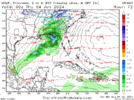
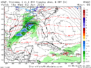
In the sweet spot for NW trend and Frontogenesis that Globals have hard time measuring. The precip bleeds and expands northward moreso. All models are showinf a little bit of something at this point mid week but HRRR/RAP/NAM will be big in showing just how expansive it could be.This feels like it was one step away from being a decent run for N GA/Carolinas.
View attachment 139622


Concord and Mount Pleasant wouldn’t surprise me at all. They always seem cooler and snowy while Union County gets the shaft! ?
This is an I40 south with the sweet spot probably somewhere along I85 and Highway 74 type event because you need a good combo of WWA and CAA to drive the precip. Got to be in the cold air sector with just enough WAA and not have too much of either.Concord and Mount Pleasant wouldn’t surprise me at all. They always seem cooler and snowy while Union County gets the shaft! ?
6Z GFS southward jog as wellDid anyone notice the euro went from Snowshoe to Whiteville on the weekend event or nah
Thanks for the kind words. I am definitely always looking on the bright side of things, lol.He's been very good at reading the modeling since I began to follow him,
He's always positive.
Another one that when he talks I pay attention.

Euro has trended towards a classical CAD look for the weekend system. Verbatim it's has significant ice along the escarpment, but I'd assume it's a couple degree's too warm at the surface if we get a look like this.View attachment 139629


.png")