NBAcentel
Member
Huge difference here. CMC dug the vortex/TPV way more and was slower, which filtered in a nice cold source. GFS is still just so awful 

Exactly. Just nothing holding the 50/50 in place to lock in any cold air at the surface. The MSLP map is textbook if we just had some type of cold air feed. But it did move into a much better direction vs last run at the same time frame and at least gives the 18Z GEFS noise a little bit of credence.GFS probably gonna be to progressive with the northern stream to leave an adequate cold source, but it’s better then before. We could use a CMC like depiction with the northern stream slowing, and digging out ahead
I would feel a lot better if the Euro was showing that solution instead of the CMC.Canadian could’ve been really big if we slow our S/W down to let the cold air feed in faster.


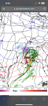
Always close lol. Yeah far away …. Got about two more weeks than maybe things will go in our favorEuro gonna be close View attachment 139324


That EURO is close to a big storm for the NC Piedmont and even the SC upstate. I think that look could trend colder as well. A 1030 high is not great but it’s not bad either. Also, as you and I both have noticed, southeast Canada has held on to its snowpack very well so there is legit cold air for that high to tap into and produce a strong CAD. We should have a fairly well establishedLast nights euro is lock step with Canadian. East TN, NC and Va Mountain snow mix with decent shot backside flake. Storm 2 right on its heels gets mix down in piedmont NC, Just like Canadian, except it had snow. Yall cant wait for the holy grail pattern, slam dunk storm to show up late Jan into Feb. But we got 2 close (not guranteed) shots coming up in the day 5 to 9 range.
View attachment 139327
Catch the flakes and store 'em away as it could be awhile, lol. I'm merely teasing.Arriving in Jasper Georgia for work this morning to snow flurries - 36 degrees
Sent from my iPhone using Tapatalk
By "close" I think we need the 850mb freezing line to be about 250 miles further south. Might that be too far to ask for this pattern? I don't see any iterations of origin data on the GEFS ensembles to suggest a move that far south. Cold rains inbound for Atlanta for the next two weeks.That EURO is close to a big storm for the NC Piedmont and even the SC upstate. I think that look could trend colder as well. A 1030 high is not great but it’s not bad either. Also, as you and I both have noticed, southeast Canada has held on to its snowpack very well so there is legit cold air for that high to tap into and produce a strong CAD. We should have a fairly well established
-NAO at that point as well to slow that high down a tad.


Would love to trend the shortwaves stronger but on the same track. Stronger system = better snow shield. Heavier precip = dynamic cooling and more people cashing in on heavy wet flakes.Looks like a parade of storms tracking across the gulf in the next ten days or so but just lacking any cold air sources. Maybe areas in the midsouth can time one up just right and score. Heck I hope everyone on the board can score.
Catch the flakes and store 'em away as it could be awhile, lol. I'm merely teasing.
Enjoy!

For clarification, you are in Jasper, GA reporting conditions there, versus your location on your member tag, right?It’s been coming down briskly for the past hour or so - hey, I will take what I can get at this point
Sent from my iPhone using Tapatalk
I can confirm that all we got was a rock here in Sandy Springs. By which I mean sprinkles…For clarification, you are in Jasper, GA reporting conditions there, versus your location on your member tag, right?

Yeah I was meaning close for the NC Piedmont and SC Upstate… where the 540 line is close by. It’s probably a long shot especially at this lead but something to watch forBy "close" I think we need the 850mb freezing line to be about 250 miles further south. Might that be too far to ask for this pattern? I don't see any iterations of origin data on the GEFS ensembles to suggest a move that far south. Cold rains inbound for Atlanta for the next two weeks.
Yeah I was meaning close for the NC Piedmont and SC Upstate… where the 540 line is close by. It’s probably a long shot especially at this lead but something to watch for
 .
.Spontaneous combustion by 2030!540 line don't mean crap anymore with the boundary layer on.
Sent from my iPhone using Tapatalk

Thats all im chasing,
For clarification, you are in Jasper, GA reporting conditions there, versus your location on your member tag, right?