Just looking at what we got. Posted it in the October thread.You feel ok? Who are you and where is the real SD?
Sent from my SM-G920V using Tapatalk
Sent from my SM-G955U using Tapatalk
Just looking at what we got. Posted it in the October thread.You feel ok? Who are you and where is the real SD?
Sent from my SM-G920V using Tapatalk

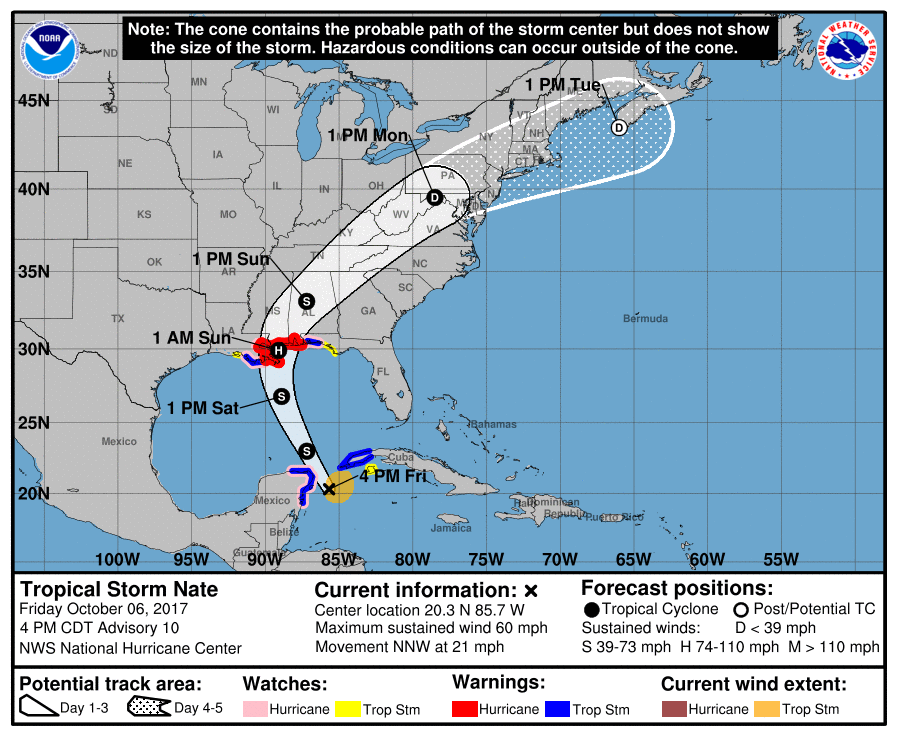
Sustained? Or gust?Ouch. 50 mph sustained near Birmingham inland.
Sustained. Glad Alabama already declared state of emergency because that would mean some nasty winds for the state. Georgia is going to get it too, as the center clips the corner of the state per latest track.Sustained? Or gust?
??? It clearly says sustained? lolSustained? Or gust?
Like I said earlier, I think this will be worse than Irma for AL and parts of GA. But it seems like the media is not really giving this as much attention as Irma. Stores are not jam packed like they were for Irma, despite the fact this may be worse for our area.Sustained. Glad Alabama already declared state of emergency because that would mean some nasty winds for the state. Georgia is going to get it too, as the center clips the corner of the state per latest track.
Lol, yeah i didn't see that before??? It clearly says sustained? lol
Me being in SW Bama it should get ugly here alsoSustained. Glad Alabama already declared state of emergency because that would mean some nasty winds for the state. Georgia is going to get it too, as the center clips the corner of the state per latest track.
Like I said earlier, I think this will be worse than Irma for AL and parts of GA. But it seems like the media is not really giving this as much attention as Irma. Stores are not jam packed like they were for Irma, despite the fact this may be worse for our area.
Why is this unfavorable for tornadoes ? I thought being on the east side is the more favorable side for tornadoes ?
Maybe the air will be too cool like it was with Irma ? I'm not sure.That is a question that I have been wondering as well. Maybe some of those with better expertise can chime in on this.

That is a question that I have been wondering as well. Maybe some of those with better expertise can chime in on this.
Without looking into the soundings a wild guess is they are expecting a large rain shield and the better tornado threat to be displaced east into Ga where the precip becomes more banded and you can generate some instability. Just a thoughtThat is a question that I have been wondering as well. Maybe some of those with better expertise can chime in on this.

The 5pm update did shift west from the 11am updateBMX may need to adjust the greatest wind impacts further W jmho I think NHC may shift back little W with track also based off the last couple runs movement is more NNE vs hard NE turn...will just have to see what happens when they do the new graphics update little later this evening
The 5pm update did shift west from the 11am update
Sent from my SM-J320VPP using Tapatalk
Why is this unfavorable for tornadoes ? I thought being on the east side is the more favorable side for tornadoes ?
You mean low max'sNate may bring us some record max low's. Lows won't be too far from avg highs.
")
BHM was already in one.It is posted above.Well im guessing BMX FFC will both be in a tropical storm watch. And MRX has not issued one as of NOW. Maybe 2AM AFD who knows...