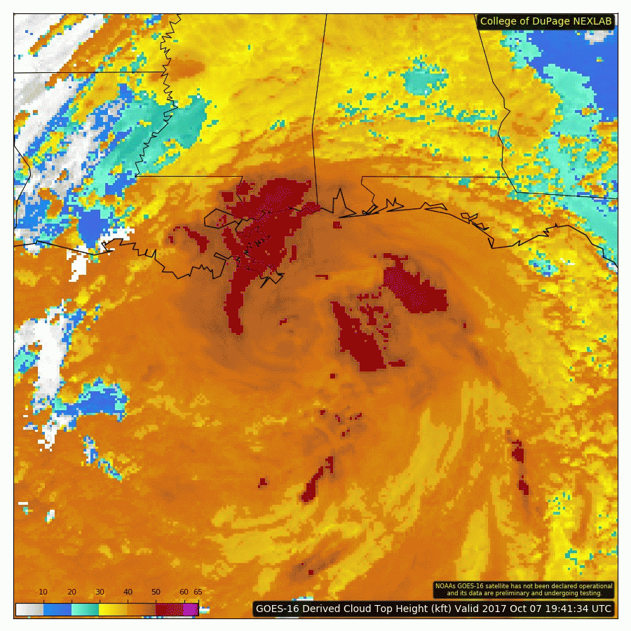
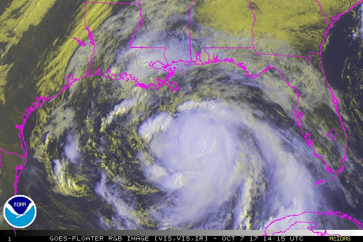
• Hello, please take a minute to check out our awesome content, contributed by the wonderful members of our community. We hope you'll add your own thoughts and opinions by making a free account!

Tropical Hurricane Nate

Some have trouble keeping this a tropical storm . Couldn't ask for a better solution. A stropical storm / weak hurricane bringing rain to the dry southeast
64d55733a54137e28b7e43d87753b801.jpg


Sent from my SM-J320VPP using Tapatalk
 
I would say im on the east side, this should be fun for me
 
Some have trouble keeping this a tropical storm . Couldn't ask for a better solution. A stropical storm / weak hurricane bringing rain to the dry southeast
64d55733a54137e28b7e43d87753b801.jpg


Sent from my SM-J320VPP using Tapatalk
And if Nate strengthens even more, those model intensity guidance will adjust before landfall i assume
 
I don't know why, but despite the obvious differences in origin and track, I like Hurricane Lili as an intensity analog. I could totally see this RI into a Cat 3-4 before hitting a brick wall right before landfall.
 
I don't know why, but despite the obvious differences in origin and track, I like Hurricane Lili as an intensity analog. I could totally see this RI into a Cat 3-4 before hitting a brick wall right before landfall.
Yeah, I have a feeling that this messy organization could flip as soon as convection comes around to the north. Given the pressure drop, we could see some strengthening today if that happens. As far as becoming a major, we could see that it we get quick organization between now and the Yucatan, and then RI in the Gulf. The energy is there.
 
I don't know why, but despite the obvious differences in origin and track, I like Hurricane Lili as an intensity analog. I could totally see this RI into a Cat 3-4 before hitting a brick wall right before landfall.

I'm always a little weary when I see a TS move over that warm eddie loop in the central GOM we have seen many times storms explode in the area...


Sent from my iPhone using Tapatalk
 
As far as landfall intensity I think it will all be determined by movement. If Nate chugs westward shear will be higher than if it moves more east along with the flow. If it can move fast along with the flow the effective shear will decrease.

If shear penetrates the core then I could easily see a senario where the coast is expecting a Cat 4 to only recieve a floundering Cat 1.
 
I'm always a little weary when I see a TS move over that warm eddie loop in the central GOM we have seen many times storms explode in the area...


Sent from my iPhone using Tapatalk

I don't know how much it matters in the case. A small fast moving hurricane would have rocket fuel well up to landfall.
 
Nate is currently east of the NHC track. Would support further development as it stays over water and further away from the Yucatan

Sent from my SM-J320VPP using Tapatalk
 
Nate is currently east of the NHC track. Would support further development as it stays over water and further away from the Yucatan

Sent from my SM-J320VPP using Tapatalk
Yep, and on TWC, fwiw, they said they didn't think the 80 mph max would verify, that it would either stay a TS, or be stronger than cat 1
 
Yep, and on TWC, fwiw, they said they didn't think the 80 mph max would verify, that it would either stay a TS, or be stronger than cat 1
Won't matter for us if the east shifts continue .

Sent from my SM-J320VPP using Tapatalk
 
Would expect another east shift in a few from the NHC

Sent from my SM-J320VPP using Tapatalk
 
12z nam takes the center right over Montgomery Alabama

Sent from my SM-J320VPP using Tapatalk
 
Back
Top