-
Hello, please take a minute to check out our awesome content, contributed by the wonderful members of our community. We hope you'll add your own thoughts and opinions by making a free account!
You are using an out of date browser. It may not display this or other websites correctly.
You should upgrade or use an alternative browser.
You should upgrade or use an alternative browser.
Tropical Hurricane Idalia
- Thread starter weather nerd
- Start date
Downeastnc
Member
Perry Airport 62 G 85 last update at 8:15
Downeastnc
Member
This will be the big story of this storm...surge looks to be huge in some places.
Basically the whole place has to be underwater with that surge based on what I remember from visiting. Very flat.
Nerman
Member
Live feed from Reed Timmer's channel
Downeastnc
Member
From first obs, looks like winds aren't mixing down to ground level very well unless I'm missing something. Storm surge and flooding seem to be the biggest issues.
Yeah didn't have time to really catch up to the pressure falls....needed a ERC and 12 more hrs before landfall to really get that going.
SUMMARY OF 900 AM EDT...1300 UTC...INFORMATION
----------------------------------------------
LOCATION...30.2N 83.5W
ABOUT 20 MI...30 KM SSW OF MADISON FLORIDA
ABOUT 45 MI...70 KM SSW OF VALDOSTA GEORGIA
MAXIMUM SUSTAINED WINDS...110 MPH...175 KM/H
PRESENT MOVEMENT...NNE OR 20 DEGREES AT 18 MPH...30 KM/H
MINIMUM CENTRAL PRESSURE...957 MB...28.26 INCHES
You’re right. Even in places that were a considerable distance from the eye and despite it being such a compact storm. This was my concern the other night that surge estimates seemed low for a category 3 coming in at a full moon along a stretch of coast that is very susceptible to surge.This will be the big story of this storm...surge looks to be huge in some places.
Charles Peek is showing damage in Perry.
Downeastnc
Member
Is it just me or is anyone else thinking this individual isn't very bright for driving around in a Cat 4/3 hurricane.
NoSnowATL
Member
Its about views and clicks now.Is it just me or is anyone else thinking this individual isn't very bright for driving around in a Cat 4/3 hurricane.
- Joined
- Jan 23, 2021
- Messages
- 4,603
- Reaction score
- 15,199
- Location
- Lebanon Township, Durham County NC
I feel pretty safe in saying that if you dont see rain from pop up storms this evening and you're north of 85 in the triangle, you may not see more than a couple tenths at best.
lexxnchloe
Member
Depending on how much it gets hollowed out we might get a good storm here.
Valdosta, GA now has winds gusting to 68mph… it appears they are going to get hit hard by that NW eyewall that smashed Perry
Nerman
Member
Valdosta Live CamValdosta, GA now has winds gusting to 68mph… it appears they are going to get hit hard by that NW eyewall that smashed Perry
Valdosta Live Cam
You know it’s interesting that with both Michael and now with Idalia, that the nw and west part of the eyewall has the strongest winds to the surface. I wonder if there is something about the geography of that stretch of the coast that contributes to this.
blueheronNC
Member
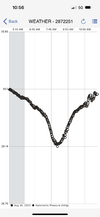
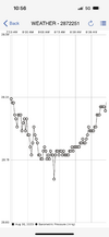
Nailed Idalia’s eye earlier.
Min pressure graph per Kestrel 5500 (altitude adjusted) was 28.19 (954.6 mb) View attachment 136676[/ATTACH]
Min pressure graph per Kestrel 5500 (altitude adjusted) was 28.19 (954.6 mb)
View attachment 136676[/ATTACH]Attachments
Last edited by a moderator:
blueheronNC
Member
In the eye, 20 feet from Josh Morgerman

Last edited by a moderator:
Always such a sharp cutoff with precip. Bone dry up here in Greenville
2 deaths confirmed from Hurricane Idalia.
Atleast you usually win on the snow cut off line. I lose out on both.Always such a sharp cutoff with precip. Bone dry up here in Greenville
Shaggy
Member
I know there are far more dangerous impacts ongoing woth idalia today and tomorrow but long term of she sits out there for 8 days spinning around the surf, beach erosion and overwash on the OBX will be significant
Curfew in Madison County, Florida from 8 PM-8 AM tonight.
There isn't much water on the eastern side of the eye and the long peninsula impends the energy if they are close to the western coast of Florida, so not a lot of energy can be picked up on that side. And, the fetch from the Atlantic comes around to the NW side of the storm, making it the "bad" side. That is my theory.You know it’s interesting that with both Michael and now with Idalia, that the nw and west part of the eyewall has the strongest winds to the surface. I wonder if there is something about the geography of that stretch of the coast that contributes to this.
Nerman
Member
The eye went to the south side of Valdosta and the NW rain shield is in Atlanta. Guess there's a 1st for everything. If the eye had gone through Macon we'd probably be seeing rain all the way to Chattanooga.Yes, I agree, they spin moisture off to the northwest but there is a limit to how far it goes. I'm saying a track through Macon might be far enough north to get the NW rain shield to Atlanta, but a track through Valdosta will definitely not. I've lived here for 45 years. I've seen this scenario over two dozen times. It never fails. This is a south Georgia, northern Florida storm. AL and the rest of GA can ignore it.
Little bit of a shift NW with QPF for NC folks
