-
Hello, please take a minute to check out our awesome content, contributed by the wonderful members of our community. We hope you'll add your own thoughts and opinions by making a free account!
You are using an out of date browser. It may not display this or other websites correctly.
You should upgrade or use an alternative browser.
You should upgrade or use an alternative browser.
Tropical Hurricane Idalia
- Thread starter weather nerd
- Start date

Cuba land interaction is only hurdle left to save day or minimize massive effects southern big bend area LF

been recalibrating after attending a bachelor party and not being clued in for 48 hours. obviously it seems the llc getting offshore quickly completely changed the calculus. i did not think this thing would get organized quickly... boy was i wrong
this is dangerous for the big bend, and it wouldn't take very many tugs east to become a big deal in a hurry for tampa. current satellite presentation is excellent. now that we're dealing with a legit entity and not a pile of scraps from the yucatan, i'm unsure what the ceiling is with this storm but it is probably higher than you think.
this is dangerous for the big bend, and it wouldn't take very many tugs east to become a big deal in a hurry for tampa. current satellite presentation is excellent. now that we're dealing with a legit entity and not a pile of scraps from the yucatan, i'm unsure what the ceiling is with this storm but it is probably higher than you think.
I agree! Big bend to Tampa had better be ready. Tampa, like you said, could take this one on the chin directly.been recalibrating after attending a bachelor party and not being clued in for 48 hours. obviously it seems the llc getting offshore quickly completely changed the calculus. i did not think this thing would get organized quickly... boy was i wrong
this is dangerous for the big bend, and it wouldn't take very many tugs east to become a big deal in a hurry for tampa. current satellite presentation is excellent. now that we're dealing with a legit entity and not a pile of scraps from the yucatan, i'm unsure what the ceiling is with this storm but it is probably higher than you think.
Stormsfury
Member
I agree! Big bend to Tampa had better be ready. Tampa, like you said, could take this one on the chin directly.
Ironically, RGEM, GFS and a couple guidance ticked west and slower on the 00z runs, which I think include the high level RECON earlierI agree! Big bend to Tampa had better be ready. Tampa, like you said, could take this one on the chin directly
And no doubt this could make a big bend to SE GA to CHS exit out for sure.Ironically, RGEM, GFS and a couple guidance ticked west and slower on the 00z runs, which I think include the high level RECON earlier
Big question for me is when does it start pulling northward and at what strength.
Official forecast major as approaches FL, wording in NHC is concerning as they acknowledge this is being conservative

iGRXY
Member
overnight guidance has definitely shifted west a bit and looking at the H5 maps this thing is getting dangerously close to missing out on the trough as it kicks east. All the talk of the south movement giving the trough time to kick it east has now turned into the south trend and southeast wobbling of the storm is quickly giving it a chance to be missed by the trough all together
Thing has a long shot of staying Hurricane entire time over land. Looks like it may spend 18 hours max, before being able to get back over water. I'm curious how it throws moisture back NW as it weakens over land, like they normally do during these transitions. Its swampy in SE GA ( Ocefenoke swamp)
We have some flies in the ointment.
I will say the new 06z GFS stalls the system off the coast after initial landfall, spins it around, and sends it's remnants back inland.
We aren't done with model shifts yet.. that's for sure.
I will say the new 06z GFS stalls the system off the coast after initial landfall, spins it around, and sends it's remnants back inland.
We aren't done with model shifts yet.. that's for sure.
Left behind, to aimlessly wander around with heights shortly rebuilding around it 

Blowing up rapidly to become a major has become the norm now for storms in the Gulf. The NHC track looks better for NC, but we could use the rain. Of course the track could shift back farther west with how the models have gone back a bit west overnight.
HWRF has a powerful can whose track has shifted a little westward.

Left behind, to aimlessly wander around with heights shortly rebuilding around it
View attachment 136537
Several members send it back over central Florida after a loop.
- Joined
- Jan 23, 2021
- Messages
- 4,603
- Reaction score
- 15,199
- Location
- Lebanon Township, Durham County NC

Looking at the model runs overnight along with the 6z GFS here’s some things that stand out.
1. Models are definitely ticking back further west which could once again put the Big Bend area back into the right front quadrant of the storm… with a major hurricane now looking increasingly likely, this could be a huge storm surge given how prone that area is.
2. If it does make landfall as a major and maintains forward speed as forecast over land, there is a serious possibility that it could maintain hurricane strength through southeast Georgia before exiting off the SC coast… it would be moving over a lot of flat swampy areas that would allow a storm to maintain strength a little longer.
3. The 6z GFS is now showing the trough leaving the storm behind and stalling it off the SE coast… this is something that the EURO showed the other day.
Looking at the model runs overnight along with the 6z GFS here’s some things that stand out.
1. Models are definitely ticking back further west which could once again put the Big Bend area back into the right front quadrant of the storm… with a major hurricane now looking increasingly likely, this could be a huge storm surge given how prone that area is.
2. If it does make landfall as a major and maintains forward speed as forecast over land, there is a serious possibility that it could maintain hurricane strength through southeast Georgia before exiting off the SC coast… it would be moving over a lot of flat swampy areas that would allow a storm to maintain strength a little longer.
3. The 6z GFS is now showing the trough leaving the storm behind and stalling it off the SE coast… this is something that the EURO showed the other day.
The runs are slowing down more and more too.. Like we are talking substatial speed changes within 06 hourly model runs vs their previous. There's definitely a struggle going on here.
The GEFS MSLP cluster is getting tighter and more confined vs previous runs.. which is expected I "guess" , but more so within 00z vs 06z only is a bit telling that something has been ingested. Are they feeding the recon data directly into/yet?
This will be a good resource to start paying attention to over the next 12-24 hours: http://tropic.ssec.wisc.edu/real-time/adt/odt10L.html
The "centers" cloud tops have dramatically cooled over night.
The "centers" cloud tops have dramatically cooled over night.
ForsythSnow
Moderator
Something else that's generally alarming when you take a look at the upper level wind development across the hurricane models is once it's a few hundred miles from the big bend, it undergoes intensification up to landfall. What I can tell is it RI's and undergoes ERC mid-gulf before intensifying more afterwards, per the models. Any different ways it could play out will likely alter the intensity modeling and forecasts drastically as well as impacts. All down to how fast this thing can intensify.
That’s one of those timing issues that we never see worked out until we’re within a few hours of landfall. You’re right though that everything from an environment standpoint indicates that this should strengthen right up until landfall.Something else that's generally alarming when you take a look at the upper level wind development across the hurricane models is once it's a few hundred miles from the big bend, it undergoes intensification up to landfall. What I can tell is it RI's and undergoes ERC mid-gulf before intensifying more afterwards, per the models. Any different ways it could play out will likely alter the intensity modeling and forecasts drastically as well as impacts. All down to how fast this thing can intensify.
Something else that's generally alarming when you take a look at the upper level wind development across the hurricane models is once it's a few hundred miles from the big bend, it undergoes intensification up to landfall. What I can tell is it RI's and undergoes ERC mid-gulf before intensifying more afterwards, per the models. Any different ways it could play out will likely alter the intensity modeling and forecasts drastically as well as impacts. All down to how fast this thing can intensify.
Personally speaking; (not a forecast) I do not think that Tampa Bay proper is out of the woods yet; Even. Very finicky setup.
It won't take too much more slowing to get this thing stuck inland somewhere, probably over SC, as the trough departs. The 6z GFS leaves it behind just offshore. I mentioned this as a possibility yesterday, but if this isn't a blip and is indeed a trend, some parts of the SE could see some pretty spectacular rainfall totals. We'll see.
NoSnowATL
Member

NoSnowATL
Member

NoSnowATL
Member

NoSnowATL
Member

NoSnowATL
Member

Nerman
Member

I think that since it’s been moving north steadily since midnight, a direct hit on Tampa is looking less likely, but still some time before we know final detailsPersonally speaking; (not a forecast) I do not think that Tampa Bay proper is out of the woods yet; Even. Very finicky setup.
ForsythSnow
Moderator
I think Apalachicola to Tampa Bay is still entirely in range and that'll be narrower tomorrow evening as we see how much Idalia wants to stay one course or another.Personally speaking; (not a forecast) I do not think that Tampa Bay proper is out of the woods yet; Even. Very finicky setup.
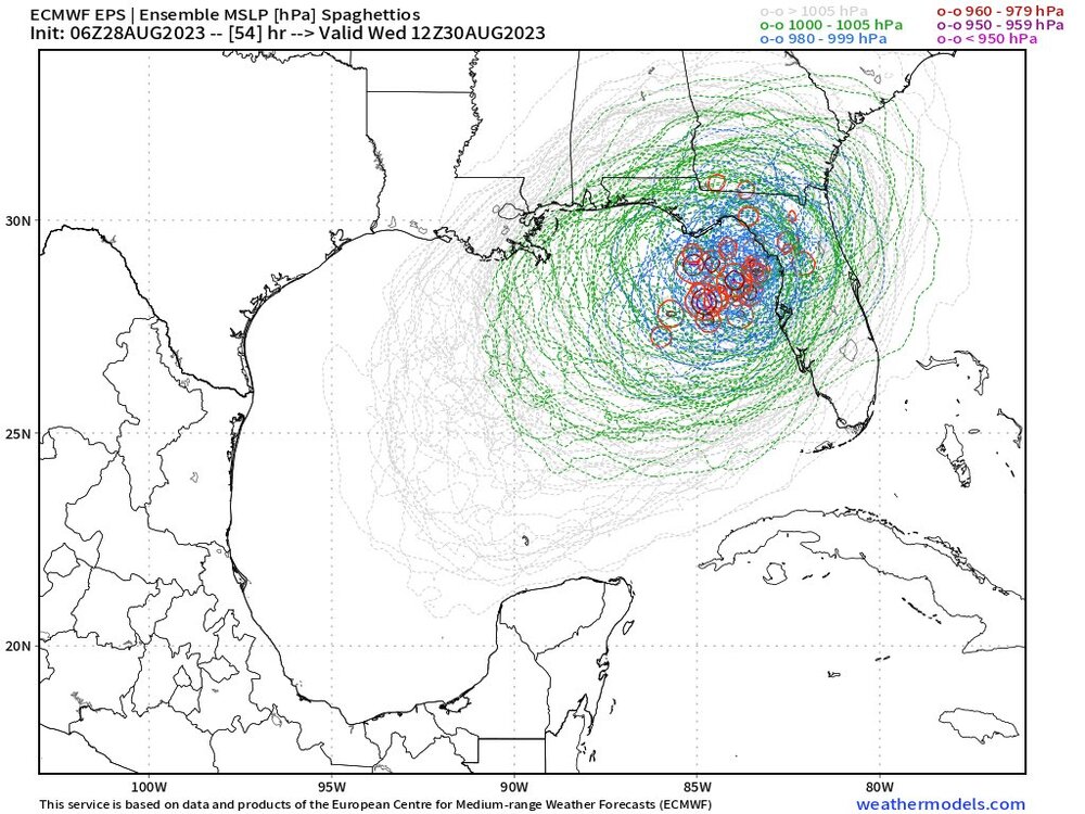
There is ever so slight tick NW and while still fairly clustered, it is a little more fanned out now, showing a little uncertainty creeping into the picture

I always thought this thing would be stronger than a Cat 1 the water temps are just off the charts I haven't looked at shear yet this morning. I could see a low end Cat 4 by the time it makes landfall.
That would be problematic. SW GA should be ok, though. I heard they were out of the woods.
HugeSnowStick
Member
LMAO, over Ronnie's house.^^^^^
NoSnowATL
Member
The NHC seems to be ignoring the tracks N and W of center. Makes me think its just a one off. Jim Cantore will be in Cedar Key so that tells me alot.That would be problematic. SW GA should be ok, though. I heard they were out of the woods.
BHS1975
Member
Shear making it hard for it to stack up still.
Sent from my iPhone using Tapatalk
Sent from my iPhone using Tapatalk
NoSnowATL
Member
Yep, its going to be lopsided for a while. Should help keep if from going boom until the last min.Shear making it hard for it to stack up still.
Sent from my iPhone using Tapatalk
NoSnowATL
Member
Definitely a couple more trying to stall it out off the southeast coastThere is ever so slight tick NW and while still fairly clustered, it is a little more fanned out now, showing a little uncertainty creeping into the picture