-
Hello, please take a minute to check out our awesome content, contributed by the wonderful members of our community. We hope you'll add your own thoughts and opinions by making a free account!
You are using an out of date browser. It may not display this or other websites correctly.
You should upgrade or use an alternative browser.
You should upgrade or use an alternative browser.
Tropical Hurricane Ian
- Thread starter severestorm
- Start date
-
- Tags
- tropical
That’s a good example. Of course Isaias went through some quick strengthening in the last few hours before landfall… I was on vacation at Oak Island during it and I swear with the surge and wind we saw it was close to cat2. It will be interesting to see how much the center starts wrapping back up. I do think it will be a hurricane again as it’s not for off at all strength wise, but I just don’t see it getting much more that 80-85mph.The structure of this storm right now reminds me alot of Isaias. It was sloppy and all convection was lopsided to the northern side
L
Logan Is An Idiot 02
Guest
Also getting stronger each run
Sent from my iPhone using Tapatalk
severestorm
Member
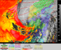
I think it's becoming extratropical now. Makes sense now from the IR and visible.It does look rough. Looking at the radar. It almost appears in the last couple frames that a new center is trying to form close to the convection

ATCF data probably upgraded it to a HurricanePossible upgrade back to Hurricane Ian at 5pm (Tropicaltidbits lists Ian as a hurricane on satellite imagery).
Tropical Cyclone Model & Best Track Archive: Current Storms
View the latest tropical storm and hurricane models mapped in ArcGIS and Google Earth.
tropicalatlantic.com
That’s certainly a possibility, but I doubt the NHC is gonna go with that yet as they aren’t gonna want people to let their guard down on the SC coast. I do want to see if possibly a new center does try to take over and wrap convection around. If it is going extra tropical, it would also explain the huge wind field the short range models are showing.I think it's becoming extratropical now. Makes sense now from the IR and visible.

Shaggy
Member
Still has the gulf stream interaction as well so it can still deepen if the storms can fire but the dry air is gonna inhibit this.That’s certainly a possibility, but I doubt the NHC is gonna go with that yet as they aren’t gonna want people to let their guard down on the SC coast. I do want to see if possibly a new center does try to take over and wrap convection around. If it is going extra tropical, it would also explain the huge wind field the short range models are showing.
Going with landfall just N of Myrtle Beach headed towards Raleigh
severestorm
Member
That's my point, it's becoming a Mid-Lattitude cyclone. Mid-Lattitude Cyclone's can deepen too.That’s certainly a possibility, but I doubt the NHC is gonna go with that yet as they aren’t gonna want people to let their guard down on the SC coast. I do want to see if possibly a new center does try to take over and wrap convection around. If it is going extra tropical, it would also explain the huge wind field the short range models are showing.
Cary_Snow95
Member
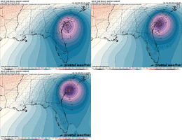
All models show that it will never wrap convection around the south side again. Likely to stay very lopsided. With it going ET though that’s probably why the winds spread out so far
uncjibble
Member
Wake County schools just closed for tomorrow, a few days ago would not have guessed that.
jeremyt
Member
I’m sticking between Charleston and MB until further notice?Still has the gulf stream interaction as well so it can still deepen if the storms can fire but the dry air is gonna inhibit this.
Going with landfall just N of Myrtle Beach headed towards Raleigh
Shaggy
Member
He's been east since before cuba so I'm riding the trendI’m sticking between Charleston and MB until further notice?
jeremyt
Member
Understood. Structure has changed. Not saying N of MB won’t happen just waiting on more solid info to bite. Gon rain either way. That’s all I wanted.He's been east since before cuba so I'm riding the trend
Blue_Ridge_Escarpment
Member
And as far west as Burke countyWake County schools just closed for tomorrow, a few days ago would not have guessed that.
Understandable… I just think that we’ve really seen things tighten up for just north of Charleston. Those EPS and GEFS means look a bit skewed by some stronger members that go north and I don’t think we’re gonna see enough strengthening to do that.He's been east since before cuba so I'm riding the trend
Shaggy
Member
Pitt County too so basically a huge swath of the stateAnd as far west as Burke county
Shaggy
Member
I think deepening is real risk due to interaction with the jet and beginning the extratropical transition so some of those stronger members could certainly be correct. Storms firing north of the center now. Still looks NNE or NE to me for the LLCUnderstandable… I just think that we’ve really seen things tighten up for just north of Charleston. Those EPS and GEFS means look a bit skewed by some stronger members that go north and I don’t think we’re gonna see enough strengthening to do that.
jeremyt
Member
How about the south side of the storm being basically eroded by dry air? Wouldn’t that effect track as well. I know the stronger the more poleward but with the trough pulling out and the dry air intrusion I’m not sure it will be enough to gain as much latitude as being shown. Although I’m not as well versed as some, I’m just giving my best educated guess based off of what I see.I think deepening is real risk due to interaction with the jet and beginning the extratropical transition so some of those stronger members could certainly be correct. Storms firing north of the center now. Still looks NNE or NE to me for the LLC
lexxnchloe
Member
I might be wrong as normal but tomorrow morning we will be surprised how much better it looks.


