ForsythSnow
Moderator
Good news is that we have an ongoing environment drop mission and 2 more planes on their way into the storm right now. Bad news is if the data is being blended into the current ICON, then you get the point.
There was some talk of that data making it into some of the 12Z model runs but I'm guessing that did not happen? It should definitely be in tonight's.Good news is that we have an ongoing environment drop mission and 2 more planes on their way into the storm right now. Bad news is if the data is being blended into the current ICON, then you get the point.
Makes more sense than everything else we've been seeing, it just had to get far enough north to kick in.Icon honestly supports a stronger storm around the Bahamas, nice outflow/anticyclone atop the storm, no tutt in its way, no crazy shear in its way,
As of now I'd say anyone along the eastern seaboard to Tx have a chance.... heck just look at the EPS members from ots to Mexico.
With that said, personally I'd lean more towards an area of say Fl/Ga line west to Tx, that high is strong and should keep this well south of us
Models having a tough time because of its small size.Is this storm being a fish completely off the table? Seems like ALL the discussion is about shred or no, intense or weak, and obviously, where it's going. Assuming it survives, it seems there is consensus it IS coming toward the SE coast. Is this accurate?
There's about a 1% chance this thing goes OTS and misses all land except PR or Hispaniola from what I think. At the sharpest recurve it would still hit NC, but that's on the extreme end of the possibilities. The other extreme is it going way west in the Gulf into Mexico. I'm pretty sure this is going to be a US threat.Is this storm being a fish completely off the table? Seems like ALL the discussion is about shred or no, intense or weak, and obviously, where it's going. Assuming it survives, it seems there is consensus it IS coming toward the SE coast. Is this accurate?
The only concern would be the models weakening the ridge over time allowing a more nnw turn. Outside of that happening this one should stay south of us here in NC.
GFS is still out to lunch and destroys it by hour 60. I'm pretty sure it's an outlier.
Main problem is it's weakening before Hispaniola. If it was strengthening up to it I'd probably not toss it out.Never bet against Hispaniola.
Main problem is it's weakening before Hispaniola. If it was strengthening up to it I'd probably not toss it out.
Yeah true, but so far it may be struggling to maintain convection, but it's still slowly strengthening. I want to see what the recon data says as well.I wouldn’t put anything past it until we actually see it organizing and strengthening as it enters the Caribbean.
What model? Link? A picture?975 in south FL....that won't be fun.

Yep. If it clears PR and Hispaniola, it's going to blow up into a major I bet. Given that possible path, I hope Floridians are at least looking at preparations. They'll have 3 days if it moves at that pace after we know if it clears or not to take action.Favorable upper level environment on the legacy GFS is putting it lightly. If Dorian makes it to the Bahamas, the upper level environment is extremely excellent & dare I say ideal...
There's an upper level low in 3 of 4 quadrants around Dorian ventilating it by day 4, thus providing it 3 outflow channels (one to the east, south, & west).
Better hope this dies over Hispaniola...
View attachment 22038
Yep...about a day ahead of the rest, but very similar path to Euro. That's new.That extra speed from the Legacy got it further north.
Are ya saying, it's possible to be more intense than the model is showing?Favorable upper level environment on the legacy GFS is putting it lightly. If Dorian makes it to the Bahamas, the upper level environment is extremely excellent & dare I say ideal...
There's an upper level low in 3 of 4 quadrants around Dorian ventilating it by day 4, thus providing it 3 outflow channels (one to the east, south, & west).
Better hope this dies over Hispaniola because a small storm like this can take off in a hurry if it's given a chance.
View attachment 22038
Absolutely yes in a scenario like this where u could have a very small storm encountering an extremely favorable environment. The biggest question marks now are what it looks like under the hood and how the models will respond which we’ll have some answers to tonight and if it survives past Hispaniola. Anything from an open wave to major hurricane is clearly and legitimately still on the table with this one without much room for error in either directionAre ya saying, it's possible to be more intense than the model is showing?
Webb,Absolutely yes in a scenario like this where u could have a very small storm encountering an extremely favorable environment. The biggest question marks now are what it looks like under the hood and how the models will respond which we’ll have some answers to tonight and if it survives past Hispaniola. Anything from an open wave to major hurricane is clearly and legitimately still on the table with this one without much room for error in either direction
 ... now back to work ...
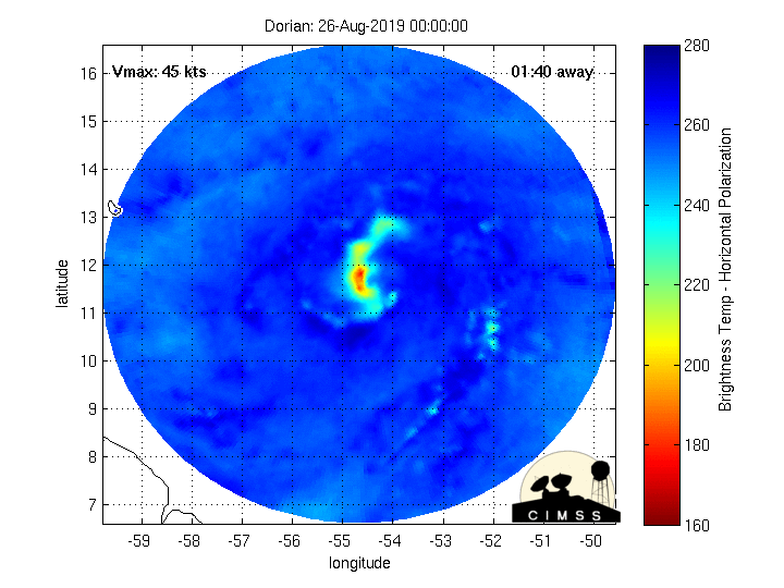
The microwave imagery is very interesting and reflects a strengthening core.If it wasn’t for the fact that Dorian has been on and off with intense convection, and hasn’t managed a CDO, I’d think it’s a weak hurricane at this point, that Convective burst is probably the strongest one I’ve seen
Yeah this is probably driving all the TC mets crazy trying to predict where this is going to go. I'm going to try and put what I see it as in one sentence:Both HWRF and HMON say RIP Dorian in the short range. That aught to be fun for forecasters.
