Ser Pounce
Member
Calm and rainy just off the Ashley River, across and up just a bit from The Citadel.
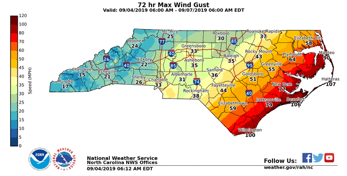
Check with your local National Weather Service. They are putting out some great graphics showing winds, precip, and timing. Here's an example for NC (Raleigh office):I saw some saying that the Euro tends to have strong winds too far inland but I see quite a few models showing around the same solution. Are most models overdoing this?

SUMMARY OF 1000 AM EDT...1400 UTC...INFORMATION
----------------------------------------------
LOCATION...29.7N 79.6W
ABOUT 90 MI...145 KM ENE OF DAYTONA BEACH FLORIDA
ABOUT 130 MI...210 KM ESE OF JACKSONVILLE FLORIDA
MAXIMUM SUSTAINED WINDS...105 MPH...165 KM/H
PRESENT MOVEMENT...NNW OR 330 DEGREES AT 8 MPH...13 KM/H
MINIMUM CENTRAL PRESSURE...964 MB...28.47 INCHES
I saw some saying that the Euro tends to have strong winds too far inland but I see quite a few models showing around the same solution. Are most models overdoing this?
06z HWRF looked the same....
80w is key
Closer to coast I think we get a more pronounced west turn soon12Z NAM is no bueno for Charleston and points north. Even brings it in NC west of OBX.
Looks like it might not make 80w. If it doesn’t get to that or just west I think it has a good chance to be off the coast.
Looking like as Dorian approached the 80W line, she pulled back East on the last few frames.
Agreed although we need to make sure it doesn’t wobble too much to the left. But no doubt that in addition to feeling much better for here, if I were living in CHS I’d be much less worried than I was when that 18Z Euro came out. The 10 AM position is the same as it has been for 2 hours, 79.6 W. The longitude of CHS is at 79.9 W. I’m not saying he won’t have one last period of some more west component of motion (if so most likely during a wobble) but he clearly has been struggling to have much west component of motion for the last few hours. All models suggest his longitude as he gets close to SC will be a fair amount east of what it is when it is due east of the FL/GA line. So, the key in my mind for CHS is his longitude once east of the FL/GA border. If it is only west to about 79.9 then, I wouldn’t see CHS getting that bad of a hit. And then IF he is only around, say, 79.7 then, that would be even better news for CHS and probably even a bit further up the SC coast.
