BHS1975
Member
Legacy gfs following 3k nam.
Sent from my iPhone using Tapatalk
Sent from my iPhone using Tapatalk
I agree that we have models that demonstrate crossing 80 and the result. But we don't have models that isolate the variations to only that component nor every decimal forward and back, so we don't truly know if it's 80 on the nose or some other component in combination that is causing it.......no big deal. Just explaining my response.For us down here it matters, and guidance bringing her in to GA through Charleston type areas had her crossing it.
My guess is that most schools under a tropical storm warning will cancel. Too much liability and risk of power outages in schools and at traffic light.Whatever county Apex is in, schools out tomorrow! Lol
Thank you for your wisdomStill moving NNW, though. Until it starts to move more east, SC and NC are not out of the woods.
Just for the archives.View attachment 23158
Hey, by the way, I didn't mean anything snarky toward you or anyone earlier. I was thinking only in terms of landfall vs no landfall.Brick, we wouldn't expect you to know.

This storm has wracked a lot of nerves ... understandably ...Hey, by the way, I didn't mean anything snarky toward you or anyone earlier. I was thinking only in terms of landfall vs no landfall.

The unexpected is about to begin......againThis storm has wracked a lot of nerves ... understandably ...
I'll leave Grateful Dead shows out of the discussion ...The unexpected is about to begin......again
Probably a good idea. ?I'll leave Grateful Dead shows out of the discussion ...


depends on who's lookin' ... LOLProbably a good idea. ?
I like the Buckley model. I need some rain although it does mess up my ots call from the beginning.
Tim Buckley
@TimBuckleyWX
·
2h
This is our in-house computer model. Notice how hardly any falls in the Triad, but over 4" falls in Raleigh. This is just one model's idea of what could happen. If bands shift west, we could get a few inches of rain. If not, we get very little.
View attachment 23162
It's an outflow boundaryGetting breezy here already. Must be a huge wind field.
Sent from my iPhone using Tapatalk
HMON hit the breaks with the eye right over the coast and HWRF stopped a bit off shore. HWRF still made LF at Cape Fear and OBX. so, ideally it takes a hard right well off shore.So when should we watch for the turn NE, and when are we in trouble for landfall if it doesn't turn by a certain time or spot?
We want it to turn before 80, BrickSo when should we watch for the turn NE, and when are we in trouble for landfall if it doesn't turn by a certain time or spot?
So when should we watch for the turn NE, and when are we in trouble for landfall if it doesn't turn by a certain time or spot?
SUMMARY OF 800 PM EDT...0000 UTC...INFORMATION
----------------------------------------------
LOCATION...30.9N 79.8W
ABOUT 130 MI...210 KM S OF CHARLESTON SOUTH CAROLINA
ABOUT 255 MI...410 KM SSW OF WILMINGTON NORTH CAROLINA
MAXIMUM SUSTAINED WINDS...110 MPH...175 KM/H
PRESENT MOVEMENT...NNW OR 345 DEGREES AT 8 MPH...13 KM/H
MINIMUM CENTRAL PRESSURE...959 MB...28.31 INCHES
Models have it turning between 12 and 18z tomorrow. That becomes problematic for the Charleston area. Taking the current speed and direction a turn at 12z given the current 8mph heading would put the center 34 miles offshore, if it is delayed until 18z it would landfall and be just inland. Now there will likely be some wobbles along three way and maybe a tendency to go just east of north later in the overnightSo when should we watch for the turn NE, and when are we in trouble for landfall if it doesn't turn by a certain time or spot?


Seems like a significant adjustment west for the New Bern area

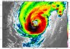
Agreed and certainly makes the exact location of the center of the eye a mute point. May come down to if those intense bands rotate in at the wrong time. It's amazing how much more broad the storm has gotten since it left grand Bahama.Size matters
View attachment 23166