• Hello, please take a minute to check out our awesome content, contributed by the wonderful members of our community. We hope you'll add your own thoughts and opinions by making a free account!

Hurricane Debby

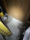
I checked my garage for the 1st time since the rain ended on Wednesday and noticed I have standing water in a small portion of my garage (along a wall) and that doors to a storage room on that side are wrinkled on the bottom despite the water having receded where they are. (see pic below) Also, cardboard boxes for things I’ve stored in there for years are damp up 6”.

It appears the water came in from below the sides of the garage door. I had thought all was ok with the house despite getting 11” over 3 days til I saw this! I got more from Matthew in 2016 within a shorter period and don’t recall much, if any, water in the garage.

Although the water has receded a good bit, the fact that there’s still 1/4” of standing water in a corner along and near a paneled wall (water barely touching baseboard) 3 days after the heaviest of Debby is a little concerning. I don’t know if the slowness to dry will lead to any issues.

It’s covered by FEMA Flood insurance, but the deductible is 2K. And filing a claim would likely increase my premium. I think the key is whether or not I’ll need a water mitigation company, which usually charge many thousands just to put in fans and dehumidifiers. If I don’t, I’d think the max damage would be below the 2K (replace doors and baseboard).
IMG_0096.jpeg
 
Last edited:
I checked my garage for the 1st time since the rain ended on Wednesday and noticed I have standing water in a small portion of my garage (along a wall) and that doors to a storage room on that side are wrinkled on the bottom despite the water having receded where they are. (see pic below) Also, cardboard boxes for things I’ve stored in there for years are damp up 6”.

It appears the water came in from below the sides of the garage door. I had thought all was ok with the house despite getting 11” over 3 days til I saw this! I got more from Matthew in 2016 within a shorter period and don’t recall much, if any, water in the garage.

Although the water has receded a good bit, the fact that there’s still 1/4” of standing water in a corner along and near a paneled wall (water barely touching baseboard) 3 days after the heaviest of Debby is a little concerning. I don’t know if the slowness to dry will lead to any issues.

It’s covered by FEMA Flood insurance, but the deductible is 2K. And filing a claim would likely increase my premium. I think the key is whether or not I’ll need a water mitigation company, which usually charge many thousands just to put in fans and dehumidifiers. If I don’t, I’d think the max damage would be below the 2K (replace doors and baseboard).

View attachment 149777
Good luck
 
FLASH FLOOD EMERGENCY!!

SCC015-019-035-090930-
/O.NEW.KCHS.FF.W.0015.240809T0529Z-240809T0930Z/
/00000.0.ER.000000T0000Z.000000T0000Z.000000T0000Z.OO/

BULLETIN - EAS ACTIVATION REQUESTED
Flash Flood Warning
National Weather Service Charleston SC
129 AM EDT Fri Aug 9 2024

...FLASH FLOOD EMERGENCY FOR MONCKS CORNER...

The National Weather Service in Charleston has issued a

* Flash Flood Warning for...
Berkeley County in southeastern South Carolina...
Charleston County in southeastern South Carolina...
Dorchester County in southeastern South Carolina...

* Until 530 AM EDT.

* At 129 AM EDT, Doppler radar numerous showers and thunderstorms
with torrential rainfall impacting much of Berkeley and Dorchester
Counties and extending into parts of central and upper Charleston
County. As much a 2 to 5 inches of rain has fallen in this area
since late Thursday evening on top of the 9 to 17 inches of rain
that has fallen over the past several days. Widespread dangerous
flash flooding is ongoing across the city of Moncks Corner. High
water rescues are in progress and a life threatening situation is
developing. Take action now. Renewed flash flood could develop
across other parts of Dorchester County as well as central and
upper Charleston County.

FLASH FLOOD EMERGENCY for Moncks Corner. This is a PARTICULARLY
DANGEROUS SITUATION. SEEK HIGHER GROUND NOW!

HAZARD...Life threatening flash flooding. Thunderstorms
producing flash flooding.

SOURCE...Radar indicated.

IMPACT...This is a PARTICULARLY DANGEROUS SITUATION. SEEK
HIGHER GROUND NOW! Life threatening flash flooding of
low water crossings, small creeks and streams, urban
areas, highways, streets and underpasses.

* Some locations that will experience flash flooding include...
North Charleston, Summerville, Goose Creek, Hanahan, Moncks
Corner, Saint George, Naval Weapons Station Charleston, Ladson,
Givhans Ferry State Park and Dorchester.

PRECAUTIONARY/PREPAREDNESS ACTIONS...

Move to higher ground now! This is an extremely dangerous and
life-threatening situation. Do not attempt to travel unless you are
fleeing an area subject to flooding or under an evacuation order.

Be especially cautious at night when it is harder to recognize the
dangers of flooding.

&&

LAT...LON 3338 7978 3332 7974 3327 7956 3326 7956
3324 7949 3324 7946 3322 7946 3319 7941
3296 7965 3293 7983 3295 8031 3302 8040
3303 8039 3305 8040 3305 8043 3318 8059
3340 7985 3337 7981

FLASH FLOOD...RADAR INDICATED
FLASH FLOOD DAMAGE THREAT...CATASTROPHIC

$$
 
Heaviest axis of rain is into Brunswick county, just a wall with a long tail firing well off shore . Totals could exceed 20 inches over the last 3 days for some folks by the end of this
 
635 AM EDT FRI AUG 9 2024

THE NATIONAL WEATHER SERVICE IN WAKEFIELD HAS ISSUED A

* TORNADO WARNING FOR...
NORTHEASTERN ISLE OF WIGHT COUNTY IN SOUTHEASTERN VIRGINIA...
THE NORTH CENTRAL CITY OF SUFFOLK IN SOUTHEASTERN VIRGINIA...

* UNTIL 700 AM EDT.

* AT 635 AM EDT, A SEVERE THUNDERSTORM CAPABLE OF PRODUCING A TORNADO
WAS LOCATED OVER KINGS FORK, OR NEAR WINDSOR, MOVING NORTH AT 40
MPH.

HAZARD...TORNADO.

SOURCE...RADAR INDICATED ROTATION.


* THIS DANGEROUS STORM WILL BE NEAR...
SUFFOLK AND KINGS FORK AROUND 640 AM EDT.
SMITHFIELD AROUND 650 AM EDT.
RESCUE AROUND 655 AM EDT.

OTHER LOCATIONS IMPACTED BY THIS TORNADIC THUNDERSTORM INCLUDE
CARROLLTON, LONGVIEW, BENNS CHURCH, WILLS CORNER, MOGARTS BEACH,
CHUCKATUCK, INDIKA, LAWSON, AND RUSHMERE.
 
I don’t understand people having the desire to stand in sewer water. I know the pandemic is over but it’s nasty and can easily catch something. I see a lot of older people doing this for pictures with Hurricane Debby. 🤢
 
ww0616_warnings_resize.gif
 
740 AM EDT FRI AUG 9 2024

THE NATIONAL WEATHER SERVICE IN STERLING VIRGINIA HAS ISSUED A

* TORNADO WARNING FOR...
SOUTH CENTRAL CARROLL COUNTY IN NORTH CENTRAL MARYLAND...
NORTHWESTERN HOWARD COUNTY IN CENTRAL MARYLAND...
NORTH CENTRAL MONTGOMERY COUNTY IN CENTRAL MARYLAND...

* UNTIL 800 AM EDT.

* AT 740 AM EDT, A SEVERE THUNDERSTORM CAPABLE OF PRODUCING A TORNADO
WAS LOCATED NEAR MONTGOMERY VILLAGE, OR NEAR DAMASCUS, MOVING NORTH
AT 40 MPH.

HAZARD...TORNADO.

SOURCE...RADAR INDICATED ROTATION.


* THIS DANGEROUS STORM WILL BE NEAR...
MOUNT AIRY AROUND 745 AM EDT.

OTHER LOCATIONS IMPACTED BY THIS TORNADIC THUNDERSTORM INCLUDE
WOODBINE, POPLAR SPRINGS, LAYTONSVILLE, LISBON, AND WATERSVILLE.
 
Back
Top