• Hello, please take a minute to check out our awesome content, contributed by the wonderful members of our community. We hope you'll add your own thoughts and opinions by making a free account!

Hurricane Debby

748 AM EDT FRI AUG 9 2024

THE NATIONAL WEATHER SERVICE IN STERLING VIRGINIA HAS ISSUED A

* TORNADO WARNING FOR...
SOUTHWESTERN PRINCE GEORGES COUNTY IN CENTRAL MARYLAND...
NORTH CENTRAL CHARLES COUNTY IN SOUTHERN MARYLAND...
SOUTHEASTERN FAIRFAX COUNTY IN NORTHERN VIRGINIA...

* UNTIL 815 AM EDT.

* AT 748 AM EDT, A SEVERE THUNDERSTORM CAPABLE OF PRODUCING A TORNADO
WAS LOCATED 7 MILES NORTHWEST OF LA PLATA, MOVING NORTH AT 40 MPH.

HAZARD...TORNADO.

SOURCE...RADAR INDICATED ROTATION.


* THIS DANGEROUS STORM WILL BE NEAR...
FORT WASHINGTON, FORT HUNT, GROVETON, FORT BELVOIR, AND HYBLA
VALLEY AROUND 755 AM EDT.

OTHER LOCATIONS IMPACTED BY THIS TORNADIC THUNDERSTORM INCLUDE BRYANS
ROAD, MOUNT VERNON, HAYFIELD, POTOMAC HEIGHTS, AND ACCOKEEK.
 
804 AM EDT FRI AUG 9 2024

THE NATIONAL WEATHER SERVICE IN STERLING VIRGINIA HAS ISSUED A

* TORNADO WARNING FOR...
NORTH CENTRAL CARROLL COUNTY IN NORTH CENTRAL MARYLAND...

* UNTIL 830 AM EDT.

* AT 804 AM EDT, A SEVERE THUNDERSTORM CAPABLE OF PRODUCING A TORNADO
WAS LOCATED NEAR WESTMINSTER, MOVING NORTH AT 40 MPH.

HAZARD...TORNADO.

SOURCE...RADAR INDICATED ROTATION.


* THIS DANGEROUS STORM WILL BE NEAR...
WESTMINSTER AROUND 810 AM EDT.

OTHER LOCATIONS IMPACTED BY THIS TORNADIC THUNDERSTORM INCLUDE
WAGNERS MILL, NEW WINDSOR, MARSTON, AND UNIONTOWN.
 
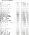
The official total so far of 16.35” for Loris seems highly dubious to me. My own calibrated gauge is showing 10.6 and there’s a CoCoRahs gauge a mile away reporting 9”. Other reports in this area are around the same and certainly not 16”.
 
823 AM EDT FRI AUG 9 2024

THE NATIONAL WEATHER SERVICE IN STERLING VIRGINIA HAS ISSUED A

* TORNADO WARNING FOR...
THE CENTRAL DISTRICT OF COLUMBIA...
WEST CENTRAL PRINCE GEORGES COUNTY IN CENTRAL MARYLAND...

* UNTIL 845 AM EDT.

* AT 823 AM EDT, A SEVERE THUNDERSTORM CAPABLE OF PRODUCING A TORNADO
WAS LOCATED OVER REAGAN NATIONAL AIRPORT, MOVING NORTH AT 40 MPH.

HAZARD...TORNADO.

SOURCE...RADAR INDICATED ROTATION.


* THIS DANGEROUS STORM WILL BE NEAR...
RFK STADIUM, GALLAUDET UNIVERSITY, NATIONALS PARK, HOWARD
UNIVERSITY, ADAMS MORGAN, ANACOSTIA, AND US CAPITOL AROUND 830 AM
EDT.

OTHER LOCATIONS IMPACTED BY THIS TORNADIC THUNDERSTORM INCLUDE THE
MALL, THE WHITE HOUSE, FOREST HEIGHTS, NATIONAL ARBORETUM, AND
BOLLING AIR FORCE.
 
827 AM EDT FRI AUG 9 2024

THE NATIONAL WEATHER SERVICE IN STATE COLLEGE PA HAS ISSUED A

* TORNADO WARNING FOR...
SOUTHEASTERN ADAMS COUNTY IN SOUTH CENTRAL PENNSYLVANIA...
SOUTHWESTERN YORK COUNTY IN SOUTH CENTRAL PENNSYLVANIA...

* UNTIL 900 AM EDT.

* AT 827 AM EDT, A SEVERE THUNDERSTORM CAPABLE OF PRODUCING A TORNADO
WAS LOCATED OVER LITTLESTOWN, MOVING NORTH AT 35 MPH.

HAZARD...TORNADO.

SOURCE...RADAR INDICATED ROTATION.


* THIS DANGEROUS STORM WILL BE NEAR...
HANOVER, PARKVILLE, AND LITTLESTOWN AROUND 830 AM EDT.
HAMPTON AND NEW OXFORD AROUND 840 AM EDT.
EAST BERLIN AROUND 850 AM EDT.

OTHER LOCATIONS IMPACTED BY THIS TORNADIC THUNDERSTORM INCLUDE
ABBOTTSTOWN.
 
The pictures are bad coming from parts of Dorchester, Berkeley counties this morning. I-26 around exit 187 is completely flooded, Moncks Corner is flooded extremely bad, Cane Bay around Nexton (just barely north of Summerville) is flooded. A colossal training set of storm after storm just battered the area overnight. All Berkeley County government offices closed today.

FB_IMG_1723206289910.jpg
 
857 AM EDT FRI AUG 9 2024

THE NATIONAL WEATHER SERVICE IN STERLING VIRGINIA HAS ISSUED A

* TORNADO WARNING FOR...
NORTH CENTRAL CARROLL COUNTY IN NORTH CENTRAL MARYLAND...

* UNTIL 915 AM EDT.

* AT 857 AM EDT, A SEVERE THUNDERSTORM CAPABLE OF PRODUCING A TORNADO
WAS LOCATED OVER WESTMINSTER, MOVING NORTH AT 40 MPH.

HAZARD...TORNADO.

SOURCE...RADAR INDICATED ROTATION.


* THIS TORNADIC THUNDERSTORM WILL REMAIN OVER MAINLY RURAL AREAS OF
NORTH CENTRAL CARROLL COUNTY, INCLUDING THE FOLLOWING LOCATIONS...
WAGNERS MILL.
 
The pictures are bad coming from parts of Dorchester, Berkeley counties this morning. I-26 around exit 187 is completely flooded, Moncks Corner is flooded extremely bad, Cane Bay around Nexton (just barely north of Summerville) is flooded. A colossal training set of storm after storm just battered the area overnight. All Berkeley County government offices closed today.

View attachment 149792
I-26 flooded over at MM 190. Also Highway 52 just before you get into Moncks Corner. I can’t remember seeing that except during the 2015 flood. And that was more concentrated toward metro Charleston. Berkeley and Dorchester really aren’t used to this type of flooding.
 
I-26 flooded over at MM 190. Also Highway 52 just before you get into Moncks Corner. I can’t remember seeing that except during the 2015 flood. And that was more concentrated toward metro Charleston. Berkeley and Dorchester really aren’t used to this type of flooding.
Exactly, SC 27 going towards I-26 is also reported to be compromised and starting to wash away. The unbelievable training bands last night produced 4 to 9" of rain in a very short time last night.
FB_IMG_1723211539458.jpg
 
Picked up just another .69" or so from showers/storms related to Debby over the previous couple days to put the storm total for me over 4". Definitely not as much as it felt, but it might be because the ground is completely soaked.

Ended up losing power for quite a while at night a couple days ago due to what I'm guessing was probably wind.
 
Waiting to hear back from ILM on the Loris sensor. I think I know what they’re using but will wait to confirm. If it’s the one at the public safety building it’s possibly getting run-off from a gabled roof.
 
People stranded in trees in PA with the flooding. Just heard a call with someone was in the tree and then the tree was swept away with the person in it.
 
The army is being called in to shutdown I95 at 3pm in Chatham/Bryan.
 
Back
Top