weather bubba
Member
It might get me some time off of work. I work in a building not too far from Crabtree Creek.Haha..I wonder how Crabtree Creek would handle that...
It might get me some time off of work. I work in a building not too far from Crabtree Creek.Haha..I wonder how Crabtree Creek would handle that...

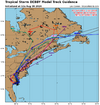
There is a very real possibility parts of 95 in southern NC will be shut down for some time after this so keep your eyes on that. That area does not handle this type of water well.So this storm is throwing wrenches at people all up and down the eastern coast. I'm suppose to go to Ft. Lauderdale starting this Thursday (driving down from Maine with dogs) for a last minute vacation....Saw the 11am updated cones of Debby....We are waiting til Sunday now to ensure that the people in the south can get what they need without more tourists driving through.
I truly hope there is no more loss of life and minimal damage from this storm, people need a break and not more trauma right now. Ya'll are really awesome at what you do and how useful your information is, even while living in Maine!
Stay Safe!
It is? Still seeing it give good data currently...Glad KRAX is down
It's back up now but it was down earlierIt is? Still seeing it give good data currently...
Drove over the Little Pee Dee earlier and the boat ramp at Fork Retch is still under water. 15” of rain in the catchment may very well put SC9 under water at Dillon and Nichols on the Lumber River, I95 at Lumberton too. US74 will most likely have issues as well around Boardman.Just got hit with that first batch out in Rocky Mount on a maintenance run. WPC keeps nudging that 10-15” up inland.
Tweeted this earlier, but RDU/greenville both have their wettest past 30 days on record coming into this. Lumberton 4th, Florence SC 8th. It won’t take long for stuff to rise
God bless you. Exactly what I been looking for,for 2 days. Very very helpful. Appreciate you passing along.
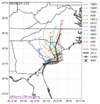
Useful tool for those in NC. You can see flood gauges for a lot of the smaller creeks as well.