• Hello, please take a minute to check out our awesome content, contributed by the wonderful members of our community. We hope you'll add your own thoughts and opinions by making a free account!

Hurricane Debby

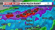
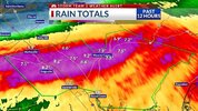
Not a complaint but more of a question for someone with more insight. I’m a mile from the Anson County line on the Union side. NWS area forecast has Peachland ( Anson County) with a forecast of possibly 11+ inches of rain over the duration , my zip code Marshville ( Union County) with 5-6 inches. I know at the end of the day what falls is what falls but a mile or two away is so much higher. I k ow we might get more than that but for people who don’t know and look at a website for info why would there be so a massive difference?
 
Not a complaint but more of a question for someone with more insight. I’m a mile from the Anson County line on the Union side. NWS area forecast has Peachland ( Anson County) with a forecast of possibly 11+ inches of rain over the duration , my zip code Marshville ( Union County) with 5-6 inches. I know at the end of the day what falls is what falls but a mile or two away is so much higher. I k ow we might get more than that but for people who don’t know and look at a website for info why would there be so a massive difference?
There's going to be a sharp drop off somewhere. The NWS just has your area in that drop off (right now). But as others have said (including NWS) the eventual track will dictate amounts.
 
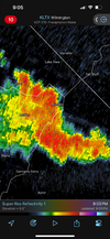
Just got hit with that first batch out in Rocky Mount on a maintenance run. WPC keeps nudging that 10-15” up inland.

Tweeted this earlier, but RDU/greenville both have their wettest past 30 days on record coming into this. Lumberton 4th, Florence SC 8th. It won’t take long for stuff to rise

Hasn't updated since 8:27 AM -

1722964068683.png
 
Not a complaint but more of a question for someone with more insight. I’m a mile from the Anson County line on the Union side. NWS area forecast has Peachland ( Anson County) with a forecast of possibly 11+ inches of rain over the duration , my zip code Marshville ( Union County) with 5-6 inches. I know at the end of the day what falls is what falls but a mile or two away is so much higher. I k ow we might get more than that but for people who don’t know and look at a website for info why would there be so a massive difference?
Speaking as someone who’s lived in Union County for 15 years, I can say that the GSP office does absolutely no collaboration with the RDU office on precip amount over Union and Anson Counties. I tend to look more at the WPC’s maps and they have the 8” line cutting through the center of Union County
 
14 GFS runs in a row through the 12Z have turned back W into the coast. But the 12Z is slightly further N and the 6Z and even moreso the 12Z GEFS mean is further N than the operational. Also, fwiw being that it’s an inferior model, the 12Z JMA 72 adjusted back N with it in VA vs yesterday’s 12Z JMA 96 in E C GA.
So, as of now the GFS will likely end up wrong, which history all along strongly suggested.

12Z UKMET: landfall Georgetown ~8AM Thu 8/8 and then heads N into VA (~50 miles E of 0Z) followed by NE turn to NE US though not as strong there as 0Z had

12Z Euro: landfall just S of Georgetown ~3AM Thu followed by NNW move into WC NC and then NE move into interior NE US, a little W of UKMET
 
Last edited:
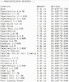
I’m always impressed with how efficient the airmass with a tropical system is at adding up rain totals. I have had anything more than a light to moderate rain that started just before 10am. It’s been steady though and already .74” in the gauge.
 
Back
Top