Mesoscale Discussion 1864
NWS Storm Prediction Center Norman OK
0447 AM CDT Thu Aug 08 2024
Areas affected...Eastern NC into southeast VA
Concerning...Tornado Watch
613...
Valid 080947Z - 081145Z
The severe weather threat for Tornado Watch 613 continues.
SUMMARY...The threat for a few tornadoes will continue through and
after dawn.
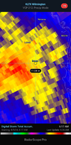
DISCUSSION...Multiple small but tornadic supercells have moved
across parts of eastern NC early this morning, within the
northeastern quadrant of Tropical Storm Debby. Thus far, the
tornadic cells have occurred along the eastern periphery of a larger
precipitation shield, where rich moisture and upper 70s F
temperatures are supporting MLCAPE of greater than 500 J/kg. Some
increase in low-level flow has been noted from the KRAX and KMHX
VWPs, with 0-1 km SRH of 200-350 m2/s2 for observed storm motions.
This magnitude of low-level shear/SRH will continue to support
tornado potential with any sustained supercell structures through
and after dawn.
The greatest short-term threat may continue in the vicinity of a
convective band from east of Raleigh to near/west of Morehead City.
However, the threat may expand to the north and east with time, into
areas where little precipitation is currently occurring,
and
somewhat stronger destabilization will be possible after sunrise. An
eventual increase in tornado threat is also possible to the west of
WW 613, depending on trends regarding ongoing precipitation and
potential for modest destabilization.