Belle Lechat
Member
- Joined
- Aug 29, 2021
- Messages
- 1,547
- Reaction score
- 1,224
TORNADO WARNING
NATIONAL WEATHER SERVICE NEWPORT/MOREHEAD CITY NC
137 AM EDT THU AUG 8 2024
THE NATIONAL WEATHER SERVICE IN NEWPORT HAS ISSUED A
* TORNADO WARNING FOR...
SOUTH CENTRAL GREENE COUNTY IN EASTERN NORTH CAROLINA...
NORTHERN LENOIR COUNTY IN EASTERN NORTH CAROLINA...
* UNTIL 215 AM EDT.
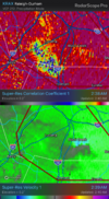
* AT 137 AM EDT, A SEVERE THUNDERSTORM CAPABLE OF PRODUCING A TORNADO
WAS LOCATED NEAR GRAINGERS, OR NEAR KINSTON, MOVING NORTHWEST AT 35
MPH.
HAZARD...TORNADO.
SOURCE...RADAR INDICATED ROTATION.
IMPACT...FLYING DEBRIS WILL BE DANGEROUS TO THOSE CAUGHT WITHOUT
SHELTER. MOBILE HOMES WILL BE DAMAGED OR DESTROYED.
DAMAGE TO ROOFS, WINDOWS, AND VEHICLES WILL OCCUR. TREE
DAMAGE IS LIKELY.
* THIS DANGEROUS STORM WILL BE NEAR...
KINSTON, DAWSON, GRAINGERS, AND KINSTON REGIONAL JETPORT AROUND
145 AM EDT.
SNOW HILL AROUND 200 AM EDT.
OTHER LOCATIONS IMPACTED BY THIS TORNADIC THUNDERSTORM INCLUDE
HOOKERTON.
NATIONAL WEATHER SERVICE NEWPORT/MOREHEAD CITY NC
137 AM EDT THU AUG 8 2024
THE NATIONAL WEATHER SERVICE IN NEWPORT HAS ISSUED A
* TORNADO WARNING FOR...
SOUTH CENTRAL GREENE COUNTY IN EASTERN NORTH CAROLINA...
NORTHERN LENOIR COUNTY IN EASTERN NORTH CAROLINA...
* UNTIL 215 AM EDT.
* AT 137 AM EDT, A SEVERE THUNDERSTORM CAPABLE OF PRODUCING A TORNADO
WAS LOCATED NEAR GRAINGERS, OR NEAR KINSTON, MOVING NORTHWEST AT 35
MPH.
HAZARD...TORNADO.
SOURCE...RADAR INDICATED ROTATION.
IMPACT...FLYING DEBRIS WILL BE DANGEROUS TO THOSE CAUGHT WITHOUT
SHELTER. MOBILE HOMES WILL BE DAMAGED OR DESTROYED.
DAMAGE TO ROOFS, WINDOWS, AND VEHICLES WILL OCCUR. TREE
DAMAGE IS LIKELY.
* THIS DANGEROUS STORM WILL BE NEAR...
KINSTON, DAWSON, GRAINGERS, AND KINSTON REGIONAL JETPORT AROUND
145 AM EDT.
SNOW HILL AROUND 200 AM EDT.
OTHER LOCATIONS IMPACTED BY THIS TORNADIC THUNDERSTORM INCLUDE
HOOKERTON.