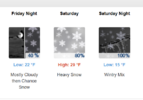
NWS needs to chill out putting out 0% predictions for the deep southTo me an Ice Storm is the cold equivalent to a Hurricane but in someways worse because no power in 70-80 degree temps is manageable but freezing temps with no power, especially if you don’t have gas is…oof
-
Hello, please take a minute to check out our awesome content, contributed by the wonderful members of our community. We hope you'll add your own thoughts and opinions by making a free account!
You are using an out of date browser. It may not display this or other websites correctly.
You should upgrade or use an alternative browser.
You should upgrade or use an alternative browser.
Misc General Banter Thread
- Thread starter Rain Cold
- Start date
Noles1812
Member
More of the same, Ice storm along I-20 and sleet to snow as you go north.Any 18z model suite prediction? (serious inquiries lol)
And where’s the best place to buy them (brick and mortar, not online)? Do you know? Walmart? Target?Whats a good power bank that can charge iphone atleast 10+ times
SnowNiner
Member
Too early to make hard and fast predictions for ANYONE as the players are not all on the field yet. That said, I have a hunch this will not go much more South and may actually come North/West some until go time. How much will be critical for p-types in all areas except the mountains, and the two things to keep your eagle eyes on are 1. What does the Baja low do, come east with the system or lag behind to the west. 2. How strong will the parent High pressure be and where does it settle at at onset of precip. The High strength is over modeled by quite a bit IMO and will end up between 1035-38 (as this happens quite frequently from my experience).
^^^ As I mentioned yesterday, the two things to look for were the strength of the High and the amount of involvement of the Baja low. I just did not think the 1045-50 High would not decrease sharply and the Baja low would cause warming issues if it amps up the system too much. Looks to me the High was modeled too high (thus cold press CAD not as stout) and the Baja low would get involved. Sure it could change but the best models are now showing that and while it will be a notable wintry event, it will not be historic IMO. Hopefully areas in Ga, SC will have temps that cut down on the ZR. Best policy is to keep abreast of the developing system and be prepared
I feel this exact way and the EURO was hinting at it.
Im oppositte. Had 3 seperate week long expierments in winter. You keep your food/ have free ice on hand to do that with. No bugs, stiffeling humidty, No worries about AC which means you sweat while trying to sleep. You can always build a fire, throw on more clothes. Heck hang out in car to warm up. But cooling down , youre screwedTo me an Ice Storm is the cold equivalent to a Hurricane but in someways worse because no power in 70-80 degree temps is manageable but freezing temps with no power, especially if you don’t have gas is…oof
Yeah, but no mosquitoes. Been there, done that.To me an Ice Storm is the cold equivalent to a Hurricane but in someways worse because no power in 70-80 degree temps is manageable but freezing temps with no power, especially if you don’t have gas is…oof
WolfpackHomer91
Member
This is the time….. the next 4 cycles (24hrs) will tell the tale. This is where it picks its way to go and it goes jmo. If we’re gonna lose it or go for glory it’s done by Tomm evening imo. The most critical runs imo are the next 4 if we’re gonna get Screwed one way or another
Sent from my iPhone using Tapatalk
Sent from my iPhone using Tapatalk
Car full of gas. Turn it on and warm up while chargingWhats a good power bank that can charge iphone atleast 10+ times
Mahomeless
Member
I can't find a single piece of truth in that statement by @MichaelJ over on the threat page.Too early to make hard and fast predictions for ANYONE as the players are not all on the field yet. That said, I have a hunch this will not go much more South and may actually come North/West some until go time. How much will be critical for p-types in all areas except the mountains, and the two things to keep your eagle eyes on are 1. What does the Baja low do, come east with the system or lag behind to the west. 2. How strong will the parent High pressure be and where does it settle at at onset of precip. The High strength is over modeled by quite a bit IMO and will end up between 1035-38 (as this happens quite frequently from my experience).
^^^ As I mentioned yesterday, the two things to look for were the strength of the High and the amount of involvement of the Baja low. I just did not think the 1045-50 High would not decrease sharply and the Baja low would cause warming issues if it amps up the system too much. Looks to me the High was modeled too high (thus cold press CAD not as stout) and the Baja low would get involved. Sure it could change but the best models are now showing that and while it will be a notable wintry event, it will not be historic IMO. Hopefully areas in Ga, SC will have temps that cut down on the ZR. Best policy is to keep abreast of the developing system and be prepared
I feel this exact way and the EURO was hinting at it.
SnowNiner
Member
This is the time….. the next 4 cycles (24hrs) will tell the tale. This is where it picks its way to go and it goes jmo. If we’re gonna lose it or go for glory it’s done by Tomm evening imo. The most critical runs imo are the next 4 if we’re gonna get Screwed one way or another
Sent from my iPhone using Tapatalk
Really, I'm just paying attention to the AIFS and the Weathernext (Google).
Interesting right now though the Google went warmer, AIFS is colder and gives us more snow. So a bit of a conflict right there, curious how it turns out. These models are so much better than even the NAM the last few storms I think.
Mahomeless
Member
I mean....come on. Maybe he's scared, but dang, don't lie to yourself about the truth of what has been modeled today.Hahaha I tried to be nice, but I was like what are you talking about
BHAMWX
Member
Heading the Home Depot after the gym tonight
bEST bUYAnd where’s the best place to buy them (brick and mortar, not online)? Do you know? Walmart? Target?
blueheronNC
Member
Has WeatherNext put NC other than the VA/NC border counties and foothills in much of the snow zone? It's been pretty consistent on mega sleet/freezing rain for much of NC since days ago I think? Would be a major and singular win if it holding serve so far with that depiction ends up being the right one.Really, I'm just paying attention to the AIFS and the Weathernext (Google).
Interesting right now though the Google went warmer, AIFS is colder and gives us more snow. So a bit of a conflict right there, curious how it turns out. These models are so much better than even the NAM the last few storms I think.
GoDuke
Member
Okay ran the generator today. Filled the truck and car up with gas. Wife made a grocery run. Winterized the spigots and some pies. Picked up some propane to grill out. We got Jack Daniels, vodka and for Bloody Marys and Jack and Coke. We ready to roll! Probably rain now though.
SnowNiner
Member
Has WeatherNext put NC other than the VA/NC border counties and foothills in much of the snow zone? It's been pretty consistent on mega sleet/freezing rain for much of NC since days ago I think? Would be a major and singular win if it holding serve so far with that depiction ends up being the right one.
Overnight it had the 850 line (more or less snow line), just north of CLT. This afternoon it jumped up just north of 40. Hoping that goes back south....AIFS keeps it just south of CLT I believe.
Lets do this... The BAJA LOW update;
18z Icon: More interaction with the Baja Low 9more amped- potential more WAA).
18z Icon: More interaction with the Baja Low 9more amped- potential more WAA).
TigerSnow
Member
Can anyone explain how the Baja low will effect our storm? More interaction versus less?
WolfpackHomer91
Member
Can anyone explain how the Baja low will effect our storm? More interaction versus less?
More = Amped…. More ICE - Canadian Family
Less = Less power but Colder and not jerked North
Sent from my iPhone using Tapatalk
WolfpackHomer91
Member

Only thing we can ask of Canadian and ICON tonight I guess
Sent from my iPhone using Tapatalk
But not in a garage. Even with the garage door open it is not safe to run a car in a garage for any extended period of time.Car full of gas. Turn it on and warm up while charging
Mahomeless
Member
It actually shifted its snow corridor further south….Lets do this... The BAJA LOW update;
18z Icon: More interaction with the Baja Low 9more amped- potential more WAA).
It’s also the ICON…which is horrendous
SnowNiner
Member
Did the High Pressure weaken though?It actually shifted its snow corridor further south….
My local Home Depot was nearly cleared out of the little propane canisters
I might have bought a few. But there were probably 50 or so left.
Local QuikTrip bumped diesel up from 2.94 yesterday to 3.44 today, because reasons
There doesn't seem to be a run on gas at least in Athens that I'm able to see.
Lots of people at the Costco today, but no sense of panic
I might have bought a few. But there were probably 50 or so left.
Local QuikTrip bumped diesel up from 2.94 yesterday to 3.44 today, because reasons
There doesn't seem to be a run on gas at least in Athens that I'm able to see.
Lots of people at the Costco today, but no sense of panic
blueheronNC
Member
Didn’t realize there was anything “typical” about this setup given the strength of the arctic cold push and pineapple express moisture feed. We may see sleet ratios that will surprise in places that change over
Mahomeless
Member
Remained unchangedDid the High Pressure weaken though?
ok cool.. thank you. the ICON is less reliable to me like the CMC I am will wait for the AI suite and GFS/EURO.Remained unchanged
I ordered like 6 of them for pickup and it's ready. Going tomorrow. Hoping they don't sell mine!My local Home Depot was nearly cleared out of the little propane canisters
Snowflowxxl
Member
Why are people trying to fake doom over the ICON and CMC
you can tell it’s been a while since we’ve done this. There will surely be a lot of broken hearts once mesoscales models start deciphering thermals in a day or two
SnowNiner
Member
you can tell it’s been a while since we’ve done this. There will surely be a lot of broken hearts once mesoscales models start deciphering thermals in a day or two
I don't know, that can go both ways. Considering the huge arctic push, it could be colder then the globals show, underestimating the CAD.
True, but in my local case if this goes bad it will be trees and power supply that will be broken not hearts.you can tell it’s been a while since we’ve done this. There will surely be a lot of broken hearts once mesoscales models start deciphering thermals in a day or two
Iceagewhereartthou
Member
Boooooooo ice. Of course the GFS was not believable being by itself but it was nice to see trends on other models going colder/snowier. Today's trend with the low interaction sucks. Still chance for that to hang back and we can pull for that but what a missed opportunity if we get stuck with all ice.
TigerSnow
Member
I am pretty sure it's ice in my area so I think I will be okay if its a little warmer.you can tell it’s been a while since we’ve done this. There will surely be a lot of broken hearts once mesoscales models start deciphering thermals in a day or two
Mahomeless
Member
I think it will undoubtedly be colder than the globals are showing…warm nose will still hurt someone most likely, but I am thinking that’s south of I-20 at this timeI don't know, that can go both ways. Considering the huge arctic push, it could be colder then the globals show, underestimating the CAD.
LongRanger
Member
Locals are showing temps around 30-31 for highs but the models are showing low 20s


