Stephenb888
Member
I see some of you are saying this run is even colder and some of you saying it’s warmer. Can’t be both which is it?

it was colder at 1am and the same at 7am. Slightly warmer in WNC.I see some if you are saying this run is even colder and some of you saying it’s warmer. Can’t be both which is it?
That much needed, if you like ZR, degree or two has been hard to come by over the last 15-20 years.

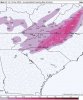
It's almost comical how well it follows the I-85 line up to the NC/SC border.this pretty much aligns with what I think View attachment 57529
Yeah for real, I’m thinking if you live along the I-85 corridor, it’s literally the difference between a degree, it could go either way, the precip isn’t that heavy either which doesn’t help until that afternoon, I guess for areas near 85 it’s more of a tree/power line ice event while areas further north it’s more of everythingIt's almost comical how well it follows the I-85 line up to the NC/SC border.


The slower this wave in the southwestern US is, the stronger the CAD is gonna be on Wed.
View attachment 57532


@Webberweather53 im seeing the same trends on the 18z RGEM
When you say for western piedmont are you referring to nc onlyThe 18z ICON was actually warmer at the sfc because it had less dynamically driven cooling from precip prior to sunrise vs earlier runs, however drizzle, freezing drizzle, and light ZR will likely start earlier than forecast by globals (as is often the case) & that's typically when the most efficient ZR accumulation will begin to occur in the far western piedmont.

When you say for western piedmont are you referring to nc only
A couple front end pingers and I’ll be ecstaticWhile the rgem May be a tad to cool in the eastern zones towards Raleigh, it’s been super consistent with this and honestly I see this as a solution if CAD was a bit stronger than modeled, just way less ice towards C NC and more towards western NC View attachment 57543
If this wave keep on slowing and let the CAD build in could you see freezing rain in ne ga or is this only a upstate and nc stormNotice on the new 18z DWD-ICON, the sfc high is a tad further south than the previous run, this is mainly because the deep-layer flow is less zonal over SE Canada as the gap between the 50-50 low & our wave in the southern branch of the jet widens, this is a synoptic-scale tweak we need to pay close attention to tonight & tomorrow as our wave gets sampled by the RAOBs and fully ingested into the models by 12z tomorrow. Having that mid-level shortwave ridge into the Lakes & Ontario is crucial in this regard in directing the low-level sfc high further south & that's a key element this particular setup is missing (if any) wrt classic CAD
View attachment 57538
View attachment 57540
While the rgem May be a tad to cool in the eastern zones towards Raleigh, it’s been super consistent with this and honestly I see this as a solution if CAD was a bit stronger than modeled, just way less ice towards C NC and more towards western NC View attachment 57543

If that energy keeps on slowing down that will help the cad to build in faster and stronger need that trend to keep goingThe 18z GFS has the energy a bit slower through 36 hours.View attachment 57546


Obvious trend here due to a slower shortwave For more filtration of lower dew points View attachment 57547


Looks like ga might be in play here if this keeps upObvious trend here due to a slower shortwave For more filtration of lower dew points View attachment 57547