JLL1973
Member
im sorry but after my water froze and busted my pipe and flooded my house last friday im done with cold. dont want no more this year
Well you may be SOL.im sorry but after my water froze and busted my pipe and flooded my house last friday im done with cold. dont want no more this year
I think we will be tracking another winter storm by Thursday or Friday of next week.
Arctic front crashing in at the end of the run(Day 10). You and me will be cold. It's coming.Euro must have been quiet
Yeah l saw that, just happens to be on my 1st Bass tournament of the season.Yeah the first weekend in February looks like our first big arctic blast from the pattern change
Sent from my SM-J320VPP using Tapatalk
This pic reminds me of being in the Cascades in February a few years back. Crazy amounts of snow!Fab Feb is on its way. This thread title might be changed as we get closer to Feb. It should be a rule that the February thread is always fab feb
Sent from my SM-J320VPP using Tapatalk
When you're in a NIÑA with a feeble subtropical jet you can create these setups wherein a trough comes out of the southwestern US if your northern stream wave enters the US at the right spot and divebombs far enough to the south and west to generate a decent moisture fetch off the Gulf. The early December event was the closest to a classic SE US setup with a s/w that dove south along the west coast and came into California along the spine of the Cascades and the Sierra Nevada instead of the Pacific. The longwave pattern that favors SE US overrunning events is also least favorable for s/ws to smack into California or the Baja Peninsula. This feature is often a missing key element in NIÑA winter overrunning threats, while the SE Canada vortex is usually absent during El Niños even though we tend to have more southern stream systems to work with. In a nutshell this means in a relative sense against climatology, moisture is often lacking during La Ninas relative to normal, while cold air is the missing relatively more often in NINOs even if the seasonal surface temperatures are colder than La Niñas. As discussed several weeks ago, while the observational record may not necessarily flesh this out due to sampling issues, if you assume the pattern will be cold in a La Niña and likewise in an El Niño and/or could reproduce a wide array of NINO and NINA winters hundreds of thousands of times and select the subset of years in both background states, you'd probably find that arctic outbreaks in the coldest NINA winters are actually more intense than those in the coldest El Niños thanks to the tendency for a blocking high epicenter near Alaska, the Bering Sea and NE Eurasia in La Ninas that's not favored as frequently in El Niños and allows Siberian air to be dumped into North America. The seasonal ENSO mean patterns from modern observations don't tell the entire story.I am really surprised at the set-ups that have produced for us this winter. The typical snowstorms that come from California seem to be absent so far. This year we have seen a glorified clipper diving down with a negatively tilted trough, a positively tilted trough all the way back to Texas and a coastal low that caught our eastern folks. I still think the "big dog" will come out of the southwest at some point before winter is over. I saw a post that targeted the 12th of February as a time frame to watch. I will say that this is a climo favored period and something to keep an eye on.
Frankly, I'm excited at the prospect of the next time it gets cold. Let's get a California s/w when that happens asap! I think the bigger storms come with those, like the Atlanta Snowjam 82', the amazing 2011 winter storm, etc. Bring it on!When you're in a NIÑA with a feeble subtropical jet you can create these setups wherein a trough comes out of the southwestern US if your northern stream wave enters the US at the right spot and divebombs far enough to the south and west to generate a decent moisture fetch off the Gulf. The early December event was the closest to a classic SE US setup with a s/w that dove south along the west coast and came into California along the spine of the Cascades and the Sierra Nevada instead of the Pacific. The longwave pattern that favors SE US overrunning events is also least favorable for s/ws to smack into California or the Baja Peninsula. This feature is often a missing key element in NIÑA winter overrunning threats, while the SE Canada vortex is usually absent during El Niños even though we tend to have more southern stream systems to work with. In a nutshell this means in a relative sense against climatology, moisture is often lacking during La Ninas relative to normal, while cold air is the missing relatively more often in NINOs even if the seasonal surface temperatures are colder than La Niñas. As discussed several weeks ago, while the observational record may not necessarily flesh this out due to sampling issues, if you assume the pattern will be cold in a La Niña and likewise in an El Niño and/or could reproduce a wide array of NINO and NINA winters hundreds of thousands of times and select the subset of years in both background states, you'd probably find that arctic outbreaks in the coldest NINA winters are actually more intense than those in the coldest El Niños thanks to the tendency for a blocking high epicenter near Alaska, the Bering Sea and NE Eurasia in La Ninas that's not favored as frequently in El Niños and allows Siberian air to be dumped into North America. The seasonal ENSO mean patterns from modern observations don't tell the entire story.

Hey Eric, I noticed that there are sometimes we do cash in with a California s/w even in either enso state. Examples like February 2010, January 2011, etc. Come to mind. So is it kinda like a balancimg act with something coming out of the southern stream at just the right time regardless? Also, are there any instances in the past where we have had southern stream system storms that we're big without a SE Canada vortex? If so, can you show some examples? Thanks.When you're in a NIÑA with a feeble subtropical jet you can create these setups wherein a trough comes out of the southwestern US if your northern stream wave enters the US at the right spot and divebombs far enough to the south and west to generate a decent moisture fetch off the Gulf. The early December event was the closest to a classic SE US setup with a s/w that dove south along the west coast and came into California along the spine of the Cascades and the Sierra Nevada instead of the Pacific. The longwave pattern that favors SE US overrunning events is also least favorable for s/ws to smack into California or the Baja Peninsula. This feature is often a missing key element in NIÑA winter overrunning threats, while the SE Canada vortex is usually absent during El Niños even though we tend to have more southern stream systems to work with. In a nutshell this means in a relative sense against climatology, moisture is often lacking during La Ninas relative to normal, while cold air is the missing relatively more often in NINOs even if the seasonal surface temperatures are colder than La Niñas. As discussed several weeks ago, while the observational record may not necessarily flesh this out due to sampling issues, if you assume the pattern will be cold in a La Niña and likewise in an El Niño and/or could reproduce a wide array of NINO and NINA winters hundreds of thousands of times and select the subset of years in both background states, you'd probably find that arctic outbreaks in the coldest NINA winters are actually more intense than those in the coldest El Niños thanks to the tendency for a blocking high epicenter near Alaska, the Bering Sea and NE Eurasia in La Ninas that's not favored as frequently in El Niños and allows Siberian air to be dumped into North America. The seasonal ENSO mean patterns from modern observations don't tell the entire story.
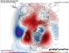
The EPS throws the entire kitchen sink at North America. Incessant ridging in the North Pacific will likely deposit Siberian air into the continent for at least the next 3 weeks (or more).
View attachment 3411
Where did you see the PNA and AO being an issue? I checked and the PNA looks to go positive by the first week of February and AO negative.Though that PNA and AO remain a bit of a concern ...
I'd say that's a pretty good analogy there buddy.January brings the all snow events their usually lighter totals and bring the powder snow. February seems to always have the big storms sometimes they can be a mix but their big. March no matter what it seems to always be big it may only come once every 5 years but it's the biggest storm in that 5 year span. That's what it always seems like at least for middle Georgia
January 12, 1982 to be exact. Good times (unless you were one of the unlucky ones stuck on the freeway!)Atlanta Snowjam 82
My post was yesterday; today's run indeed looks better, as you point out. Been too busy to update today ...Where did you see the PNA and AO being an issue? I checked and the PNA looks to go positive by the first week of February and AO negative.
")
Frankly, I'm excited at the prospect of the next time it gets cold. Let's get a California s/w when that happens asap! I think the bigger storms come with those, like the Atlanta Snowjam 82', the amazing 2011 winter storm, etc. Bring it on!
Ok. I was wondering about that. Whenever you see anything look bad just wait a day. The cold is winning out this year!My post was yesterday; today's run indeed looks better, as you point out. Been too busy to update today ...
Patience is indeed a virtue, but I have not been canonized yet ...Whenever you see anything look bad just wait a day
Must be drunk on the strongest liquor our there!I see the Happy Hour got drunk off of it's delicious wines.
Edit: If this run were to verify our guys like olhausen and others in that area are going to be happy. It's still a bit out there though.

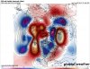
Ikr! It has snow in Miami at hour 252! Crazy!Must be drunk on the strongest liquor our there!
That map literally made me laugh when I saw it. Good grief.Ikr! It has snow in Miami at hour 252! Crazy!
Tell me about it! HahahaThat map literally made me laugh when I saw it. Good grief.
We are, indeed, in rarified air when the LR models start doing this. I think south Florida fantasy snow is just as rare as actual south Florida snow. Buckle upMust be drunk on the strongest liquor our there!
Need a due N trend ... LOL ...Ikr! It has snow in Miami at hour 252! Crazy!