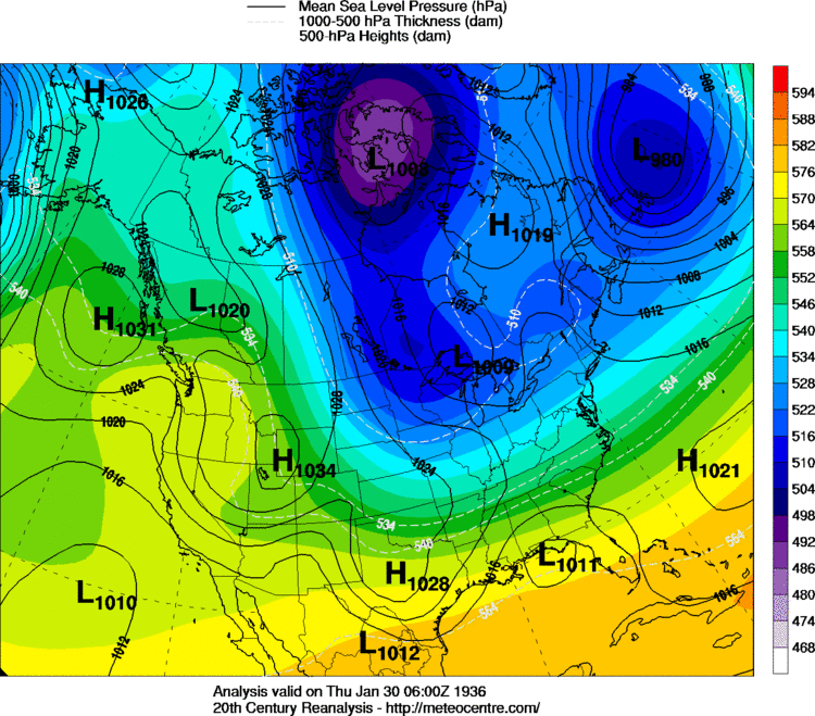
• Hello, please take a minute to check out our awesome content, contributed by the wonderful members of our community. We hope you'll add your own thoughts and opinions by making a free account!

Pattern February Discussion

Status
Not open for further replies.
Fwiw, climo always says to give an extra watch over the 2/10-14 period as history says that has been one of the two most active five day periods as regards major winter storm history at ATL, CAE (very active there), and much of the SE. Actually, it has been quite active there through 2/18. Miller A lows crossing north or central FL were often the culprit.
I can vouch for that. Two or three of the biggest snowstorms I remember came in that time frame. And is it just me or did we get more Miller A type storms back in the 60's and 70's?
 
I had a little confusion at first, the first weak system showing up 3-5th time frame won't produce much winter weather. If that low comes little further south, folks across TN and western NC could see some winter weather out of that disturbance. The one we're looking at is the bigger one that could produce a board wide event.

I was thinking that the system we're looking at will occur in the 10th-14th time period. Which it could, timing could change. Matter of fact, the 12z Euro EPS is showing the system coming along later on than the 18z GFS.

The 18z GFS is showing some good blocking off to the NE and very good strong blocking out west which will dip the trough deep 10th-12th time period. This storm signal showing up could be pushed back because the pattern during that time frame looks more reasonable for this storm signal.

Also, I think it will start to trend to an all snow event because it should trend further south because according to the GFS there is a high to the NW and NE causing ridgeing, pushing the storm further south.


Sent from my SM-J700T1 using Tapatalk
 
Looks like the models are starting to pick up on a threat again. The GFS actually did pretty good picking up on the last storm 10 to 14 days out. Of course it didn't get the exact location of where the heaviest snow would be, but it had the general idea right. Seems we have seen this before where it starts out north, then goes south, and then trends NW the closer we get. Glad to see some potential showing up again.
 
the 12z euro and 18z gfs are almost identical with the low track days 8-10

Sent from my SM-G900V using Tapatalk
 
GFS is coming. If it loses the system, I will lose it mentally.
 
I bet the GFS will have it at a later date. 10th-14th time frame. Then again, it may not have it at all.

Sent from my SM-J700T1 using Tapatalk
 
This is going to be a good test for my theory...bet we end up seeing that thing in the northeast weaker and a cutter, but I hope not.

Also, the clipper looks about the same. Nice little event for Tennessee and the mountains.
 
It's still early but that NS disturbance is still as strong as it was in the 18z, and is further south too. Now if it doesn't move or weaken...

ok nvm I'm looking at the wrong thing. I figured out what I'll need to be looking at.
 
Last edited:
The GFS is doing the same thing with the dynamics as it did in the 18z in the Northeast and Canada but it's weaker and faster.
 
This is going to be a good test for my theory...bet we end up seeing that thing in the northeast weaker and a cutter, but I hope not.

Also, the clipper looks about the same. Nice little event for Tennessee and the mountains.
Yeah it keeps holding on to my inch to inch and a half of snow. If I get at least an inch I'll be thrilled seeing how this winter has gone so far.
 
From Robert at WxSouth and the good thing about him is he doesn't look at run to run model maps, but the overall pattern that will be in place. He's very good at this stuff.
The buzz today is all about the European and GFS potential Winter storm around 9 or 10 days from now. We actually haven't seen many of those progged this Winter, yet. Mainly because of how warm it's been. Oddly, the early January event was forecast , pretty nicely, from 10 days out, generally speaking overall. I go over the speculation and why, and how things must come together just right, with the right timing of the Southern stream system, the location of the Cold Vortex in Maine, and pressing strong cold high pressure to keep the System far to the South. There's plenty of time to watch and see how this evolves, but for now, and considering the Alaskan block again (just like in early Jan), this is a pretty interesting setup. I'm not saying break out the snow shovels just yet anywhere in the Southeast, but....Winter's not over, despite another warm up next week.
16300207_1563340337029349_184143590760019953_o.jpg
 
Last edited:
I don't think this one is going to do it, I might be wrong but that stuff up in the northeast isn't as strong as it was in 18z. Its there but not as strong. It's hanging on though, so far.
 
H5 is much different , gonna be a much warmer run regardless of any system

Sent from my SM-G900V using Tapatalk
 
Status
Not open for further replies.
Back
Top