LukeBarrette
im north of 90% of people on here so yeah
Meteorology Student
Member
2024 Supporter
2017-2023 Supporter

????
Get that low to dig some more further south/slow down...probably wouldn't be a bad look
Sent from my SM-A136U1 using Tapatalk
anafrontal hell
Clipper snow is a way to score

Southern Mid-Atlantic is not included in this conversation ?Wow…. F off, The Mid- Atlantic is gonna score again and still whine. Luckiest region on earth. “Ohhh it’s not 3 feet we aren’t interested “ eat a ----. Like UNC fans when they don’t win a title dude I’d love to even be in the game much less win
Sent from my iPhone using Tapatalk
Ok. Perhaps you didn't see what thread your were in?Wow…. F off, The Mid- Atlantic is gonna score again and still whine. Luckiest region on earth. “Ohhh it’s not 3 feet we aren’t interested “ eat a ----. Like UNC fans when they don’t win a title dude I’d love to even be in the game much less win
Sent from my iPhone using Tapatalk


Ok. Perhaps you didn't see what thread your were in?
Ok.No I saw it, was responding to the post.
Sent from my iPhone using Tapatalk
If you are thinking about punting winter away, like I did yesterday. Whatever you do, don't go look at the 0Z CFS for March. The "Delayed but not Denied" quote has big legs to stand on.

If you are thinking about punting winter away, like I did yesterday. Whatever you do, don't go look at the 0Z CFS for March. The "Delayed but not Denied" quote has big legs to stand on.
post it or it doesnt exist..lolIf you are thinking about punting winter away, like I did yesterday. Whatever you do, don't go look at the 0Z CFS for March. The "Delayed but not Denied" quote has big legs to stand on.
Interesting and something to watch, again the Euro hinted at this too (not as robust but still)Ai model has this for Saturday FWIW it nailed the snow today in Pa, NY etc…
Sent from my iPhone using Tapatalk
i'm keeping an eye on this for my advantaged latitude and i think you should tooAi model has this for Saturday FWIW it nailed the snow today in Pa, NY etc…
Sent from my iPhone using Tapatalk
i'm keeping an eye on this for my advantaged latitude and i think you should too


Man how does Boston feel this morning. 10-15 inches in the forecast as late as yesterday for themMore snowpack to our north with this day 4 deal for the MA/NE...does that help us?
Looks like the dam has finally busted for NYC. And somehow the MA crew just keeps cranking out events in a horrific winter for most.
View attachment 146387
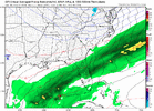
Closer but still fairly far away...it's totally trolling usGfs was close ?


I get the pessimism from many but it’s not likely the models have this nailed 120hrs out, plenty of time to trend better or worse. Seeing a flake for the first time in 2 years is a win so I’ll keep tracking until it’s dry and 45If this little northern stream vort max can just come in a little further west and a tick stronger than depicted, it would phase with the southern stream disturbance earlier and we'd have something here. That's really pretty close with only hints of that N/S energy on other modeling though.
Wait…are we getting sucked in again? We sure are a glutton for punishment.Probably would be snow if precip got to the NC Piedmont, but without a great cold air source, it’ll be 32-34 degree slopfest that struggles to stick and continually melts from underneath once it does. But I guess beggars can’t be choosers.
I do think this one has legs. Probably well under a 50/50 proposition, but what isn’t around here?
Wait…are we getting sucked in again? We sure are a glutton for punishment.


.gif")