• Hello, please take a minute to check out our awesome content, contributed by the wonderful members of our community. We hope you'll add your own thoughts and opinions by making a free account!

Pattern February 2024

We get to go to the
Big Dance( pattern)!

Prettiest Girl (wave)Said yes!

We are hoping the DJ (cold Air) shows up and if hes there, no doubt will play ou Favorite tunes and the pretty girl will be happy and dancing our tune.

But when get to the dance and the DJ is 12 hours late, our pretty girl is just gonna sit there and cry cold rain tears and tell us no more dates after tonight, she doesnt want to see us again and we will have to wait till next years dance(winter 2024) to ask , see if there is another pretty Girl.

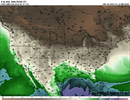
Its all gonna come down to timing the cold air arrival at just the right time. If its early and sets up his stuff before or just in time. We good! Jury is gonna be out all week.
 
The GEFS was wetter this run
aaf772a5e108cf231931947342af3284.gif


Sent from my SM-A136U1 using Tapatalk
 
We have a -pdo, which isn't typical in niños. That probably has something to do with the no backloaded this winter. Also, the cold air going to Asia again isn't helping. I definitely can see a pretty cold March and even April evolving with rapid demise of niño. Also, the SSW ongoing. We will really need unreal timing to get a winter storm moving forward imo, which can and has happened
 
I mean that was quite the run to run change. Last run was suppression city gulf coast rain at best. Temps in the upstate and NC hovering just below freezing the whole duration. This run was farther north hp was slow to move in however after some onset rain was a decent run for foothills/piedmont/mountains of nc. GFS was also a little bit of a jump makes you wonder if these are just normal model jumping. Obviously just some op runs but both being not great makes you wonder.
 
GEFS pretty split on outcomes. Some amped, some suppressed, some wintry, some not, and some wintry south of I-20 so I’d say still a good spread of possibilities. Tells me there’s still time needed to sort some things out for better or worse.

Edit: here’s the best frame to show some of the solutions and the snow members
IMG_9960.jpegIMG_9961.png
 
Last edited:
It’s like when we lose a medium range pattern these days it happens in about 6 hours. Billions of dollars worth of modeling can’t even account for the issues we’re having and have had in the pacific for years now. I don’t know what it is but the east coast as a whole even at latitude is having a tough time. You have to think this will flip violently at some point.
 
I mean it’s easy to say “well it just doesn’t get cold here anymore.” But when you’re bordering a super El Niño coupled with a northern stream as active as it is and has been, you don’t even have a chance to get cold air anywhere nearby. You’re fighting two jets and are NEVER able to get any kind of overrunning high pressure established into the pattern. It’s a fools errand. Yeah we get the 50/50 low but we only get that because there’s 10,000 waves from both streams crashing into it feeding it at all times.
 
It’s like when we lose a medium range pattern these days it happens in about 6 hours. Billions of dollars worth of modeling can’t even account for the issues we’re having and have had in the pacific for years now. I don’t know what it is but the east coast as a whole even at latitude is having a tough time. You have to think this will flip violently at some point.

It doesn’t flip because pattern persistence seams to dominate. Without cross polar flow there is no source. Period. We had 10 days of it in January.


Sent from my iPhone using Tapatalk
 
The overnight move on models to undercut the ridge out west is just awful. We can’t win this year. That new wrinkle not only ruins our chances on feb18-20, but it seems to lead to the pv setting up shop in central Canada down the road as well which is no good for us. Double whammy failboat.

There’s still time for those undercutting solutions to be wrong though.
 
The lack of cold air isn’t just a problem for the South. It was nearly 60 here in Chicago this week. We may get snow next week from clippers but our temps will still be AN and accumulations will be meager. The predicted northeast systems are trending north and will depend on dynamic cooling with crappy ratios. Minnesota is having an epic snow drought. It’s everywhere except the mountain west.


Sent from my iPhone using Tapatalk
 
Back
Top