View attachment 145691
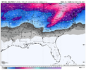
CAD was a big theme on 6z GEFS

GEFS extended wasnt bad either last night. By far its snowiest run of the entire winter.
View attachment 145691
CAD was a big theme on 6z GEFS

Several members showing mixed precipitation on top of that as well, pretty active 06z run, in that timeframe of interestPretty significant movement on the midterm storm on the GEFS with now 6/30 members showing snow. At 0z, I believe it was one.
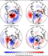
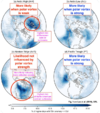
Yet the GEFS, CMCE, EPS, and GEPS all show plenty of cold air available in CanadaThe main lobe of SSWE headed to Asia so there won’t be much cold on this side of the hemisphere unfortunately.
Sent from my iPhone using Tapatalk
Bring that HP down into New York and we will be cooking with gasPretty remarkable that the GFS had a big WNC/MA snowstorm at 06z looking like this…warning shots? Possibilities will always be there when you get a big sprawling HP in the mix View attachment 145697
lol i mean it's not like the core of the other lobe has temps in the 80s and dews in the 60s that's not a death knellThe main lobe of SSWE headed to Asia so there won’t be much cold on this side of the hemisphere unfortunately.
Sent from my iPhone using Tapatalk
Signal still there!Some big HP on the gefs members View attachment 145698

 www.facebook.com
It's a fair point in the sense that it doesn't look like we are going to have a big Arctic outbreak (Alaskan Ridge pattern regime). Those can work out for snow as seen in the Mid South last month, but what we are shooting for this time around is this Arctic High pattern regime (-AO/-NAO) in conjuction with El Nino. This Arctic High regime is much more likely to occur when the SPV is in a weakened state...the stratosphere evolution is a key player here, and it continues to trend favorably. The big Alaskan Ridge regime with big Arctic outbreak would deliver cold air, but it would wreck our -NAO as Fro has mentioned before because it leads to strong high pressure dropping down east of the Rockies, then +N American Mtn Torq > N Atlantic jet speeds up and breaks down the blocking on the Atlantic side.The main lobe of SSWE headed to Asia so there won’t be much cold on this side of the hemisphere unfortunately.


Is the midterm event the ~VD storm or the ~PD storm?EPS and ICON havent moved south with the midterm event nearly as much as GEFS so I'd go with them for the moment.
It’s the Valentines Day system. In fairness, I’m not certain that we want it to trend south much. One of the keys for the 17th-20th time period is getting a good 50/50 low established underneath that -NAO block. The EPS, CMCE, EURO, CMC, and ICON are all showing the Valentines Day system doing that.Is the midterm event the ~VD storm or the ~PD storm?
