• Hello, please take a minute to check out our awesome content, contributed by the wonderful members of our community. We hope you'll add your own thoughts and opinions by making a free account!

Wintry February 19-21, 2020 Winter Storm

Just so everyone is clear: I am referring to my back yard. Some folks are going to do very well today. Of that I have no doubt. But for the NW Piedmont, it's probably going to finish on the low side. I'll be more than happy to have a pie of crow if I am wrong.
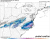
I think your best bet is that the overrunning proves to be a bit heavier/further northwest than progged. We've certainly seen models miss that plenty of times even at the last second, but I wouldn't get my hopes up necessarily. Probably a 1-3" type event in the Triad, IMO (and more likely to the lower end of that, especially as you move NW).

I'm going with 2-4" for Durham, 3-6" for Raleigh. We'll see.
 
Nam has been pretty consistent with my area, had 1 spike run of 7 inches in areas yesterday, but mostly its been adverting 2-5 through Randolph county. We are on the west edge. So your talking a tenth to two tenths qpf. Very impressed how it perfirmed from 84hrs to go time today. Hands down beat the globals to the punch imo.
 
Chattanooga has a chance to change over before those heavy returns get there...
Um that’s melting a loft more so than heavy returns. Temps in the mid 30s with light to steady precip.
 
Perhaps part of the problem for the NW Piedmont is the angle of approach. The precipitation is coming primarily from the west—over the mts and into relatively dry air. If the overall system were not so flat and the returns were approaching from the SW, then things would be different.

Good luck to everyone from RDU east. I hope you get a good one.
 
The changeover in the Upstate is at the Gaffney, Boiling Springs, TR area which is way ahead of schedule for the NAM. 850's are solidly below freezing in the northern upstate and 925's are right at freezing so this is a very good sign in my opinion.
 
d587802aec7e2bc04b9b088abc86db7c.gif


That’s like 18+ hours of snow for NE NC.
 
From what I can try to tell, there seems to be snow in Chattanooga now. Can anyone there confirm? Also the CC line is nearing Dalton now.

nearest wx station near my office off Mansell was showing 39 down here a while ago. NE wind was howling. Not expecting anything, but I was surprised.
 
The changeover in the Upstate is at the Gaffney, Boiling Springs, TR area which is way ahead of schedule for the NAM. 850's are solidly below freezing in the northern upstate and 925's are right at freezing so this is a very good sign in my opinion.
I see some spotty sleet reports in northern upstate but that's all
 
Latest HRRR has 7-8" down IMBY at hr 18 and still snowing decent with several more hrs to go....starting to think 6-10" is doable would be the biggest snow here in a solid 10 years if we get 8" or more....still would feel better if the temps would crash a bit lol....still the 925/850's are going to be plenty cold once we get the heavier banding setting up it should go all snow fast and surface temps will crash.
 

Attachments

  • sn10_acc_us_ma.png
    sn10_acc_us_ma.png
    160.8 KB · Views: 91
Perhaps part of the problem for the NW Piedmont is the angle of approach. The precipitation is coming primarily from the west—over the mts and into relatively dry air. If the overall system were not so flat and the returns were approaching from the SW, then things would be different.

Good luck to everyone from RDU east. I hope you get a good one.
I definitely agree here .. I think the faster you get saturated the easier it is to get more returns and more precip in any one area
 
Something to point out on the latest NAM runs .. they don’t have as much precip in Tennessee as there actually is .. returns are back building and are easily up to the Kentucky Tennessee border and the NAMS have precip no where further than the middle of Tennessee
 
Perhaps part of the problem for the NW Piedmont is the angle of approach. The precipitation is coming primarily from the west—over the mts and into relatively dry air. If the overall system were not so flat and the returns were approaching from the SW, then things would be different.
Good luck to everyone from RDU east. I hope you get a good one.
CAD is actually to blame for bringing dry north-East winds with low dp. Usually it’s confined to Surry/Wilkes but I think the issue became more widespread when you start to compound transfer issues it’s like a double whammy for the entire Triad region west. Those stale cold dry winds will work to eat away some precip but maybe not all.
 
Back
Top