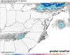
I’m not a fan at how the RAP ended with its P-type maps, but then again, looking at soundings, this is mostly snow. I have a hard time trusting models that are saying that precip over NC is rain.


that's WAA on steroids.. or at least some video sign stealing...I’m not a fan at how the RAP ended with its P-type maps, but then again, looking at soundings, this is mostly snow. I have a hard time trusting models that are saying that precip over NC is rain.
View attachment 35490View attachment 35491
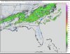
I’m not a fan at how the RAP ended with its P-type maps, but then again, looking at soundings, this is mostly snow. I have a hard time trusting models that are saying that precip over NC is rain.
View attachment 35490View attachment 35491
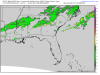
I’m not a fan at how the RAP ended with its P-type maps, but then again, looking at soundings, this is mostly snow. I have a hard time trusting models that are saying that precip over NC is rain.
View attachment 35490View attachment 35491
I’m not a fan at how the RAP ended with its P-type maps, but then again, looking at soundings, this is mostly snow. I have a hard time trusting models that are saying that precip over NC is rain.
View attachment 35490View attachment 35491


Euro is only out at hour 30, it's not go time yetAnd the euro showing nothing as usual

.png")
Euro fell flat on its ass with this setup


That's 12z run
They are bad, but they will have some time to come down over the next 36 hours or so. It is going to be important we get heavy precip, though, as these soil temps could keep the snow from sticking as quickly as it would otherwise (and there will be melting underneath). I would like to see these come down to at least around 40 before snow starts falling. I know people love to make fun of soil temps as a meaningful factor, but there’s a reason the NWS RAH WFO includes a discussion of soil temps in some of their after action reports.I'm not a fan of these soil temps.
View attachment 35420
Not that it means anything tonight, here’s how accurate the NAM 00z run was 6 hours out. Will be radar watching like a hawk tomorrow. I’ve enjoyed tracking and watching this event take shape. And I hope someone gets absolutely buried by this setup.When it comes to thermals, neither the NAM nor the Euro is going to be the final product. It's going to come down to nowcasting (as always) Our best bet is for some heavy returns to keep overriding the same area's. Tonight's radar is something I wouldn't mind seeing on Thursday. Lot's of back building and expansive coverage.


Looks like it’s getting colder as the precipitation moving in
Precip looks laterLooks like it’s getting colder as the precipitation moving in