Clem282340
Member
Is that good or badPrecip looks later
Is that good or badPrecip looks later
6z RGEM is looking solid too.6Z ICON has increased qpf as well, especially over the western Piedmont. Kudos to the NAM, which has really led the way with this one.


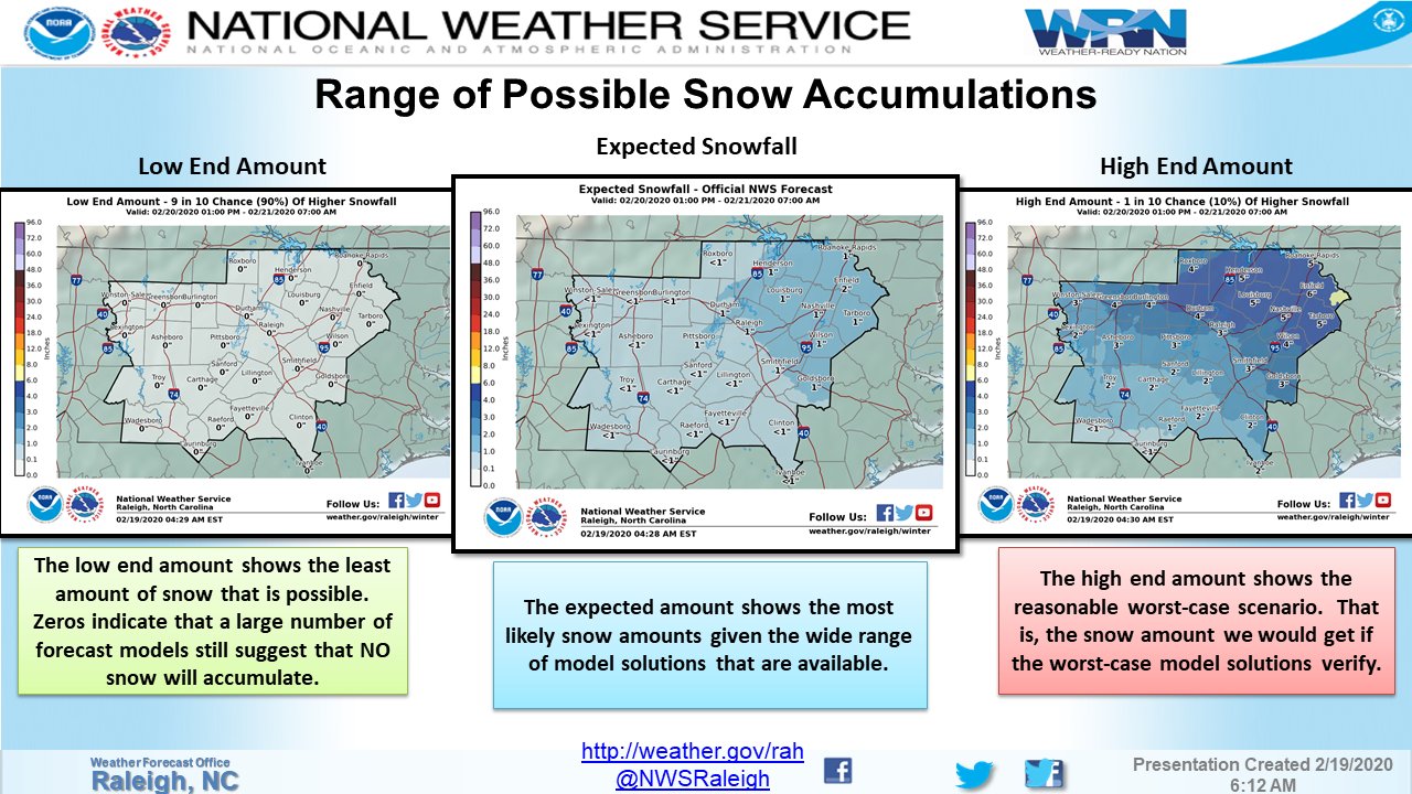
Here's the HIGH END map from the NWS for NC. If you were to press me on a forecast map, I'd trim this by about 20-25% and say it would be pretty close to what happens.

No changes from me for my county. Stickong woth 3-6 county wide. Enjoy, pnly about 28 hrs till statt time. Nam led way on this so far.
I'm curious on your thoughts about the NWS discussion. It seemed well written and thought out, but maxed out accumulations at 1-2 inches and no watches being issued. I'm guessing that they will ramp things up this afternoon, but that will be with less than 24 hours lead time.I'm thinking something in the ballpark of 4-8" for the Triad & Triangle areas.


I gotta say personally I was leaning towards those lower amounts too but the RGEM has me rethinking that. I've always liked that model and the 6z run was amazingHere's the HIGH END map from the NWS for NC. If you were to press me on a forecast map, I'd trim this by about 20-25% and say it would be pretty close to what happens.

I gotta say personally I was leaning towards those lower amounts too but the RGEM has me rethinking that. I've always liked that model and the 6z run was amazing
Here's my first call map w/ actual totals. I think the northern coastal plain and NE piedmont is going to get clocked.
View attachment 35515
Right, which is way seeing the RGEM ramp up gives me reason to start liking those higher totals. Today's 12z run should be very tellingIMO the model to follow is the 3km NAM and RGEM later today blended together. Everything has been trending to the overall NAM idea. Rgem caved, euro caved, and other models have too in recent days. The NAM and RGEM blend at 12z today should be pretty close to what actually happens. The 6z RGEM was a massive jump towards the NAM too with widespread 4-5” amounts and still snowing at the end of the run on pivotal.
I’d be thrilled with 3-6” of snow and sleet here. Considering many here including myself had given up on winter in NC I’ll take this in a heartbeat. I hope the higher nam totals are right though, I want a foot ?
Here's my first call map w/ actual totals. I think the northern coastal plain and NE piedmont is going to get clocked.
View attachment 35515
Good call. I am thinking the same.thing, but I still think that sweet spot will dip down and cover Wake. I can't move from my prediction I made a couple of days ago of Wake northeast to Norfolk now. Gotta stick with my guns.
Right, which is way seeing the RGEM ramp up gives me reason to start liking those higher totals. Today's 12z run should be very telling

Ok, I know we don't want to discuss the decisions that every NWS station makes, but this tweet is just plain wrong and misleading. Under the low end map it says:
"Zeros indicate that a large number of forecast models still suggest that NO snow will accumulate."
I don't think there is any model that show not accumulating snow for the entire Raleigh area is there?

I have to say I strongly disagree with the NWS discussion on snowfall amounts. I understand they are playing it safe right now but their discussion about temperatures being an issue isn’t valid imo if you look at the best model for thermals in this range, the 3km.
Temps QUICKLY crash to 32 across areas as the moderate to heavy precip moves in on the 3km nam. It is the best model imo with thermal profiles inside 48 hours and the NWS has been burned many times in recent memory by ignoring it.
View attachment 35513
Once the event really gets going we have a large area of 30-32F temps.
View attachment 35514
Also regarding precip, the 3km NAM is forecasting close to an inch for the RDU to Wilson corridor and then 1-1.5” of qpf East of there. Assuming the NAM rain/snow line is correct, even an average 5:1 ratio as discussed would yield 4-5” for Raleigh to Wilson and 5-8” east of there. I think they’re making the mistake of looking at globals for thermal profiles, something they’ve done repeatedly over the years while seemingly ignoring the 3km NAM for some unknown reason.
New RGEM looked good, finally.IMO the model to follow is the 3km NAM and RGEM later today blended together. Everything has been trending to the overall NAM idea. Rgem caved, euro caved, and other models have too in recent days. The NAM and RGEM blend at 12z today should be pretty close to what actually happens. The 6z RGEM was a massive jump towards the NAM too with widespread 4-5” amounts and still snowing at the end of the run on pivotal.
I think there having flashbacks of when they forecasted several inches of snow and we got 40s and rain.
Sent from my iPhone using Tapatalk
The changeover is starting around 11-12 and likely will go until 8-10. Might want to up that some.Upstate sc areas looks more like a quick blow to me. North of 85 Dusting to 2 inches. Amount depends on When it turns to snow. 2-6pm that’s maybe 4hrs the grounds warm it take time to stick. Any change over before 1-2pm would be good to see a decent event. I really feel this comes down to what time the changeover happens. Dusting to 2inches is my gut feeling on this one
Sent from my iPhone using Tapatalk
The changeover is starting around 11-12 and likely will go until 8-10. Might want to up that some.
