------------- is claiming victory. Now Hold my Bo ice tea. Well go(inserted clean version) I wish he would stop lying. He said bread&milk storm and told schools to shutdown. Over this? I wish he had higher standards because he is altering plans of families and hurting local economies of the Charlotte metro market. There is a big difference in playing it safe and being wrong to cause panic. If you would like to further this conversation let’s move it over to banter. Thank-you.
-
Hello, please take a minute to check out our awesome content, contributed by the wonderful members of our community. We hope you'll add your own thoughts and opinions by making a free account!
You are using an out of date browser. It may not display this or other websites correctly.
You should upgrade or use an alternative browser.
You should upgrade or use an alternative browser.
Wintry February 19-21, 2020 Winter Storm
- Thread starter Six Mile Wx
- Start date
Webberweather53
Meteorologist
hard to say, on the vehicles probably 4-5", in the yard 3-4" but its also packing down....looking at radar its tough to tell how much longer this will last...there appears to be some enhancement between RDU and Goldsboro that is moving into my area this may be what has caused my flake size to improve....the real question is how long does this last....if somehow we can squeeze 2-3 hrs of this kind of rate and flake size in then I think we got a legit chance at 6"+....just hard to say how how it plays out at this point, earlier the HRRR had the best rates etc from 10-2 so maybe thats what we are seeing....
Yeah for snow accumulation I typically use a vehicle if I don't have a snow board because it's closer to that (and what's officially reported) vs the ground unless of course you have a lot of snow (thus may not matter as much in either case). The last band's accumulation efficiency should be considerably higher than what you've seen thus far, so 6" seems achievable.
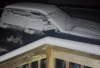
About 4” on the back deck and cars, just under 3” in the grass, no slant sticking!
Nomanslandva
Member
Good you love your job Phil. Does not get any better than that! For me up here, it was a big flaming nothing burger, but glad others scored! And at least is is cold enough for me to have may wood stove going and no bugs outside for the moment!Oh I play ... it's called work and I love my sandbox ...
... and love weather so long as no one is hurt by it ... relish what y'all had/have today and tonight ... ?
")
The other Phil
Webberweather53
Meteorologist
PUBLIC INFORMATION STATEMENT
NATIONAL WEATHER SERVICE RALEIGH NC
1034 PM EST THU FEB 20 2020
...SNOWFALL REPORTS AS OF 1030 PM EST...
LOCATION AMOUNT TIME/DATE PROVIDER
...NORTH CAROLINA...
...ALAMANCE COUNTY...
BURLINGTON 2.0 IN 1015 PM 02/20 PUBLIC
...CHATHAM COUNTY...
6 W BYNUM 1.8 IN 0732 PM 02/20 PUBLIC
1 NE SILER CITY 1.5 IN 0607 PM 02/20 PUBLIC
1 ENE GOLDSTON 1.4 IN 0657 PM 02/20 PUBLIC
...CUMBERLAND COUNTY...
5 NNE FAYETTEVILLE 0.8 IN 1021 PM 02/20 PUBLIC
FAYETTEVILLE 0.5 IN 0921 PM 02/20 PUBLIC
5 NNE FAYETTEVILLE 0.5 IN 0911 PM 02/20 PUBLIC
HOPE MILLS 0.5 IN 0822 PM 02/20 TRAINED SPOTTER
...DAVIDSON COUNTY...
THOMASVILLE 1.0 IN 0611 PM 02/20 EMERGENCY MNGR
3 WNW LEXINGTON 1.0 IN 0608 PM 02/20 PUBLIC
...DURHAM COUNTY...
7 SE GORMAN 2.7 IN 1017 PM 02/20 COCORAHS
1 SSE PARKWOOD 2.0 IN 1008 PM 02/20 PUBLIC
DURHAM 2.0 IN 0902 PM 02/20 PUBLIC
...FORSYTH COUNTY...
3 W PFAFFTOWN 1.0 IN 0600 PM 02/20 PUBLIC
...FRANKLIN COUNTY...
3 NE YOUNGSVILLE 4.0 IN 0912 PM 02/20 PUBLIC
...GUILFORD COUNTY...
2 SSE SUMMERFIELD 2.0 IN 0815 PM 02/20 TRAINED SPOTTER
5 E COLFAX 2.0 IN 0800 PM 02/20 OFFICIAL NWS OBS
3 SSW GIBSONVILLE 2.0 IN 0630 PM 02/20 PUBLIC
GREENSBORO 1.5 IN 0929 PM 02/20 PUBLIC
HIGH POINT 1.3 IN 0630 PM 02/20 BROADCAST MEDIA
...HALIFAX COUNTY...
ROANOKE RAPIDS 2.5 IN 0918 PM 02/20 SHIP
...HARNETT COUNTY...
3 E PINEVIEW 1.5 IN 0815 PM 02/20 PUBLIC
COATS 1.5 IN 0745 PM 02/20 PUBLIC
...JOHNSTON COUNTY...
BENSON 2.5 IN 1005 PM 02/20 PUBLIC
1 E LINWOOD 2.2 IN 0801 PM 02/20 PUBLIC
3 NNW FLOWERS 2.0 IN 0700 PM 02/20 PUBLIC
6 N COATS CROSSROADS 1.9 IN 0926 PM 02/20 PUBLIC
CLAYTON 1.9 IN 0722 PM 02/20 PUBLIC
EMIT 1.5 IN 0731 PM 02/20 TRAINED SPOTTER
5 WNW COATS CROSSROADS 1.5 IN 0645 PM 02/20 TRAINED SPOTTER
2 E PINE LEVEL 1.2 IN 0902 PM 02/20 PUBLIC
...LEE COUNTY...
BROADWAY 1.5 IN 0709 PM 02/20 PUBLIC
...MONTGOMERY COUNTY...
TROY 2.8 IN 0916 PM 02/20 PUBLIC
STAR 2.0 IN 0839 PM 02/20 PUBLIC
CANDOR 1.8 IN 0932 PM 02/20 PUBLIC
...MOORE COUNTY...
4 SW CARTHAGE 2.3 IN 0956 PM 02/20 PUBLIC
...ORANGE COUNTY...
2 N EFLAND 2.5 IN 0730 PM 02/20 PUBLIC
4 NNW EFLAND 2.1 IN 0630 PM 02/20 PUBLIC
2 S CARR 2.0 IN 0604 PM 02/20 PUBLIC
...PERSON COUNTY...
ROXBORO 3.3 IN 0757 PM 02/20 PUBLIC
...RANDOLPH COUNTY...
4 SE ASHEBORO 1.8 IN 0745 PM 02/20 PUBLIC
3 ENE SEAGROVE 1.5 IN 0742 PM 02/20 PUBLIC
ASHEBORO 1.0 IN 0517 PM 02/20 LAW ENFORCEMENT
...VANCE COUNTY...
HENDERSON 2.8 IN 0925 PM 02/20 PUBLIC
...WAKE COUNTY...
4 NE WENDELL 3.1 IN 1001 PM 02/20 PUBLIC
4 NE RDU INTERNATIONAL 3.0 IN 0947 PM 02/20 BROADCAST MEDIA
5 SSW GARNER 2.8 IN 0951 PM 02/20 PUBLIC
PURNELL 2.7 IN 0920 PM 02/20 TRAINED SPOTTER
2 N RALEIGH 2.5 IN 0831 PM 02/20 PUBLIC
6 W FALLS LAKE 2.3 IN 0924 PM 02/20 COCORAHS
4 NNE RALEIGH 2.3 IN 0856 PM 02/20 COCORAHS
1 S CARY 2.2 IN 0800 PM 02/20 PUBLIC
5 W PURNELL 2.0 IN 0914 PM 02/20 PUBLIC
WAKE FOREST 2.0 IN 0825 PM 02/20 PUBLIC
4 SSW RALEIGH 1.5 IN 0700 PM 02/20 OFFICIAL NWS OBS
...WARREN COUNTY...
1 N ARCOLA 1.8 IN 0613 PM 02/20 PUBLIC
...WAYNE COUNTY...
1 SW GOLDSBORO 1.3 IN 0838 PM 02/20 PUBLIC
3 N MAR-MAC 1.1 IN 0845 PM 02/20 PUBLIC
...WILSON COUNTY...
LUCAMA 2.3 IN 0955 PM 02/20 PUBLIC
2 ESE NEW HOPE 2.0 IN 0858 PM 02/20 PUBLIC
Shaggy
Member
About 4” on the back deck and cars, just under 3” in the grass, no slant sticking!
That was a significant hour for my snow totals. Left to take my wife to work at 9:15 and got back at 10:20. Had easily added an inch of snow the lawn went from potmarked lumpy looking snow to that smoothed over look and the roads had gotten worse as the temp on my car was down to 30 out here away from town. Just measured 3.75 on my outdoor table but the bottom was slushy and compacted.
NBAcentel
Member
Hmmmm 
Blane20181990
Member
Snowing pretty good in Pikeville NC still. Just lost power about 10 mins ago.
Shaggy
Member
Short video of the snow on my way home near PGV
Has it ever snowed in Bermuda? I always think that would be the penultimate Atlantic out to sea snow storm.
HRRR putting Atlanta on flurry watch early in the AM
rambleon
Member
2.75" (compacted) on elevated surface outside chapel hill with 1 more band to swing through. not going to wait up for it. still 33*.
Nope. It’s never gotten colder than 43 degrees on record.Has it ever snowed in Bermuda? I always think that would be the penultimate Atlantic out to sea snow storm.
GAwx, take us back to some mythical storm in the 1700s where it snowed in Bermuda....Nope. It’s never gotten colder than 43 degrees on record.
Blane20181990
Member
NBAcentel
Member
very light flurries #winning
GoDuke
Member
Was thinking the exact same thing. Glad someone said it.------------- is claiming victory. Now Hold my Bo ice tea. Well go(inserted clean version) I wish he would stop lying. He said bread&milk storm and told schools to shutdown. Over this? I wish he had higher standards because he is altering plans of families and hurting local economies of the Charlotte metro market. There is a big difference in playing it safe and being wrong to cause panic. If you would like to further this conversation let’s move it over to banter. Thank-you.
Stormsfury
Member
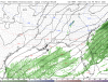
You can see how quickly the precip has eroded here.
Actually KCHS is discussing another burst or precipitation possibly developing over the tri- county area as various short range models indicate this along and north of the I-26 corridor per latest AFD
Downeastnc
Member
Alright last one going to sleep, radar drying up and I will be lucky to squeeze another .5" out of whats left to work through....got 4-5" but probably 6+ has fallen, its compacted a lot on the vehicles and still 5" deep.
Sctvman
Member
41/38.6 right now on James Island.
Actually KCHS is discussing another burst or precipitation possibly developing over the tri- county area as various short range models indicate this along and north of the I-26 corridor per latest AFD
Stormsfury
Member
38 here and drizzling in Goose Creek. 925mb cold enough but 850mb still running about 2C41/38.6 right now on James Island.
Precip starting to develop ITP right now. Now we just wait and see if anything frozen actually makes it to the surface over the next few hours. 925mb (-1C) and 850mb (-3C) temps are subfreezing according to SPC.HRRR putting Atlanta on flurry watch early in the AM

COD-NEXLAB : Dual-Pol Radar for FFC
Dual-Pol NEXRAD Data for provided by College of DuPage Meteorology (NEXLAB)
 weather.cod.edu
EDIT: 4Z HRRR This is wild, snowband sitting right over me with DBZs in the 30-35 range. That's heavy snow.
Attachments
Last edited:
38 here and drizzling in Goose Creek. 925mb cold enough but 850mb still running about 2C
Our bigger storm is coming man. It can't keep holding out forever (I hope).
The 2014 localized deal here, I think you saw some not too long ago along the coast.. these nickle and dime events.. soon.. hopefully.
This nasty band has setup right over Newport News and points East as the coastal is starting to pivot...heavy snow but 6 miles back to the west it’s bone dry
WxBlue
Meteorologist
3.7" is probably our final total here.
Sctvman
Member
1/3/18 here was crazy. But the cutoff was so sharp. I think Orangeburg had 5” that storm while Columbia had almost nothing. And it basically skipped over Horry County. That snow didn’t melt till that next Monday here. Six days. You probably have to go back to ‘14 for the last SC-wide storm.
Our bigger storm is coming man. It can't keep holding out forever (I hope).
The 2014 localized deal here, I think you saw some not too long ago along the coast.. these nickle and dime events.. soon.. hopefully.
Stephenb888
Member
Does anyone think South Carolina will ever see a big snow storm again? I’m not talking northern upstate. I’m talking everyone even below the dreaded i85 line. It’s been a while.
Yes. But there’s a reason CAE (for example) averages so little snow. It just doesn’t snow that much. Keep in mind Columbia recorded over half a decade’s worth of snow in a single storm in 2010 (the Valentine’s Day storm). But it’s been a pretty bad drought since, for sure.Does anyone think South Carolina will ever see a big snow storm again? I’m not talking northern upstate. I’m talking everyone even below the dreaded i85 line. It’s been a while.
Clem282340
Member
Maybe just got to get everything time just right really need a storm to come in at night instead of during the day to maximize colder airDoes anyone think South Carolina will ever see a big snow storm again? I’m not talking northern upstate. I’m talking everyone even below the dreaded i85 line. It’s been a while.
BufordWX
Member
Getting some very light returns developing nearby. Will be interesting to see what happens with them.
Half an hour ago it was raining, but it looked like there could have been some wet flakes mixed in or maybe I'm just delusional idk.? ?
?
EDIT: Temp dropped to 38/34. WB is 36.5
?EDIT: Temp dropped to 38/34. WB is 36.5
BufordWX
Member
Starting to get some showers here as well. 36.9/36.4. Have to imagine if the temperature goes down another degree or two it will change to snow given the cold upper air in place.Half an hour ago it was raining, but it looked like there could have been some wet flakes mixed in or maybe I'm just delusional idk.?
EDIT: Temp dropped to 38/34. WB is 36.5
BufordWX
Member
Not 100% sure right now but might be getting a mix of rain and some tiny snowflakes. 36.5/36Starting to get some showers here as well. 36.9/36.4. Have to imagine if the temperature goes down another degree or two it will change to snow given the cold upper air in place.
olhausen
Member
Glad you scored some snow buddy!!! You are always so positive and calm even when things are looking very gloomy winter weather wise. I like seeing people get snow who aren’t constantly declaring winter is over from December on.Measured some areas with 2 inches and some with 3 inches ... overall this was probably the wettest snow I’ve seen in a while.. stuck to literally everything in sight and you could pick it up and squish it a bit and an immediate snowball .. for this crappy winter this was an A+ event for me ... truly love seeing and tracking winter weather and it’s what got me into weather in the first place .. that’s why my inner weenie comes out a lot when tracking this type of stuff
Sctvman
Member
Nerman
Member

Lake Lanier snow effect taking place. I don't think FFC believed it when they wrote it but here it is. They have to be laughing.
Webberweather53
Meteorologist
Looks like most folks area-wide either verified the low end of my forecast map or busted low, I think air temps being in the middle 30s, just above freezing coupled w/ warm ground temps and dendrites that weren't efficient at accumulating to begin with caused most of the issues wrt snow accumulations. I'm very curious to hear about what everyone received in their backyards when the final flakes fell.
I got 3". It looks like RDU airport received 2.5"Looks like most folks area-wide either verified the low end of my forecast map or busted low, I think air temps being in the middle 30s, just above freezing coupled w/ warm ground temps and dendrites that weren't efficient at accumulating to begin with caused most of the issues wrt snow accumulations. I'm very curious to hear about what everyone received in their backyards when the final flakes fell.
From their climate report: SNOWFALL (IN) YESTERDAY 2.5 R 0.8 0.1 2.4 0.0
My back yard temp has fallen to 25. Still got over 2" on all elevated surfaces and grass. Its frozen solid and feels more like sleet. Temps today are suppose to stay in the 30s to lower 40s. As RAH states this will set us up for our coldest night.
RAH:
As the center of the high reaches central North Carolina tonight, winds will become nearly calm. Clear skies and calm winds will allow for maximum radiational cooling tonight, and considering the fresh snow cover, have under cut model guidance by a few degrees. The predicted low of 21 degrees at RDU would make it the coldest night of the season - the coldest temperature of the season so far at RDU has been 24 degrees.
Watch out for icy roads this morning. The main road in front of my house looks clear but its ice covered:
